

Agritech & Spatial Data: Predicting Crop Yield in Agriculture


This post was written by NGIS our master reseller in Australia and New Zealand and was originally published on their website.
--
Building Rural Intelligence For The Agricultural Sector
Digital Agriculture Services (DAS) is an Australian rural technology company that caters to the growing appetite for rural agribusiness and climate risk intelligence that puts science in the hands of decision makers.
Backed by CSIRO Australia’s national science and innovation agency DAS software answers questions existing technology cannot answer with industry-leading agribusiness data workflow and collaboration tools.
DAS which applies artificial intelligence (AI) and machine learning to deliver new Software as a Service (SaaS) solutions engaged NGIS to help build a spatial web application known as the DAS Cropping Hub. The DAS Cropping Hub was built using breakthrough AI to detect crop types and predict crop yield based on historical data and proven CSIRO science.
The globally scalable Hub one of several in the company’s growing software suite leverages the DAS Rural Intelligence platform which covers over 1.8 million geo-located rural and agricultural parcels and properties along with more than 371 million hectares of agricultural land.
Stakeholders Require Fast And Accurate Data
Agribusiness is one of the most complex industries in the world. With stakeholders from farmers to finance insurance to investors rural real estate to logistics commodity handlers and government the demand for data and spatial information at paddock farm regional state and country level has never been higher. These subsectors are looking to answer questions such as:
- What crops are growing where?
- What is the expected production of major crop types?
- How do growing season conditions and forecast production compare to previous seasons at the National State and Local Government levels?
The DAS team had the data technology vision and design capabilities to answer these questions but needed the assistance of a trusted partner to deliver the spatial elements of the solution to improve its presentation speed and accuracy. This was the beginning of what would eventually become the DAS Cropping Hub.
{% include icons/icon-quotes.svg %} Working with the NGIS team was a pleasure the team was efficient flexible knowledgeable and provided a quick turnaround for any issues that came up during the project.
Sagit Shiran Head Of Product At Digital Agriculture Services (DAS).
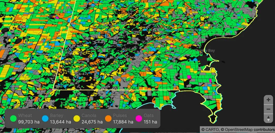
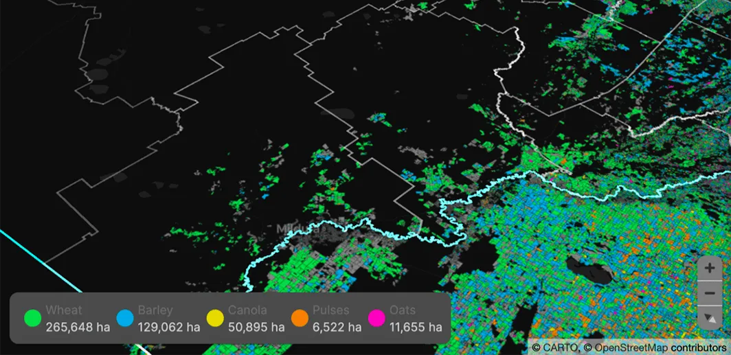
Classifying Crops and Yield Prediction in Australia
NGIS worked closely with the DAS team to build out the Cropping Hub prototype application that matched their designs and user stories. The goal was to build an in-season crop monitoring and identification tool that provides crop yield forecasts productivity monitoring and benchmarking.
While still in its early days Cropping Hub provides insights across Australia’s Winter cropping regions giving users current statistics and historical context to help make informed and accurate decisions.
Using Google Earth Engine Cropping Hub can classify what crop is growing where in around 1.7M paddocks across Australia and then apply a proprietary yield prediction algorithm developed by CSIRO. Data is summarised by State and Local Government Areas to provide DAS clients with more accurate crop intelligence by geolocation.
The web application built on CARTO Engine and hosted on Google Cloud enables the DAS team to update the data at high frequency to ensure clients have the most up-to-date information possible.
Further the data that exists today in Cropping Hub can be imported into the Rural Intelligence platform so it becomes another high value data source the team can use.
Unlocking the power of spatial analysis
Cropping Hub has enabled the DAS team to take future steps together with their customers unlocking the power of spatial analysis for the cropping and grains industry - and helping transform how different businesses operate and trade within the agricultural sector.
DAS is now working with industry leaders to rapidly refine the technology and classification process yield predictions accuracy and data insights that better enable decision making.
{% include icons/icon-quotes.svg %} This was a first successful iteration and now we can engage in many more conversations and build on top of an existing solution.
Sagit Shiran Head Of Product At Digital Agriculture Services (DAS).
Want to see this in action?


