

Announcing CARTO BigQuery Tiler General Availability


Introducing BigQuery Tiler
The simplest way to create and publish map tilesets from BigQuery.
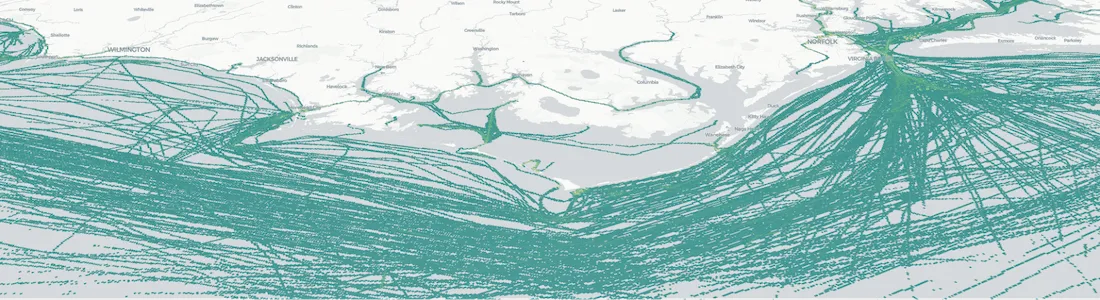
We are excited to announce the general availability of CARTO BigQuery Tiler, a unique solution for visualizing massive spatial datasets hosted in Google BigQuery.
Today's announcement follows 6 months of intensive beta testing by our enterprise customers, partners, and CARTO users. We have been impressed with the applications and maps that have been created using the solution.
The general availability of BigQuery Tiler represents a major milestone in our journey to build the world's leading cloud native spatial analytics platform and our first step to develop comprehensive Spatial Analytics on Google's cloud platform. Check out our video for an overview.
Having closely supported beta implementations over the past 6 months our team has further enhanced the Tiler and integrated it with the rest of the CARTO platform. Here are some of the key highlights.
Access BigQuery directly through our new connections page
Now on the dashboard you will be able to create and persist BigQuery connections that you use regularly. So no need to enter connection parameters every time.
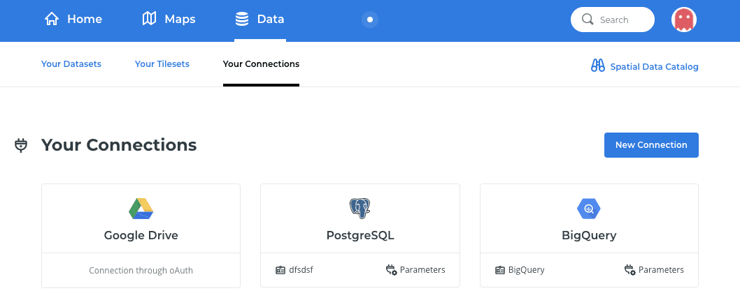
We have also changed the way the BigQuery connector works to make use of a Service Account. That way, you can leverage the same connection for the entire organization and set more granular permissions. We have created some useful documentation to help you get started.
To coincide with this release we have also made our full range of database connectors available to all CARTO users, regardless of their pricing plan. These can be accessed through the dashboard's “Your Connections” section.
Integration of tilesets within the dashboard
It is now possible to explore and visualize all tilesets related to your BigQuery projects directly from our simple user interface. These can be accessed through a “Data” option in the main menu.
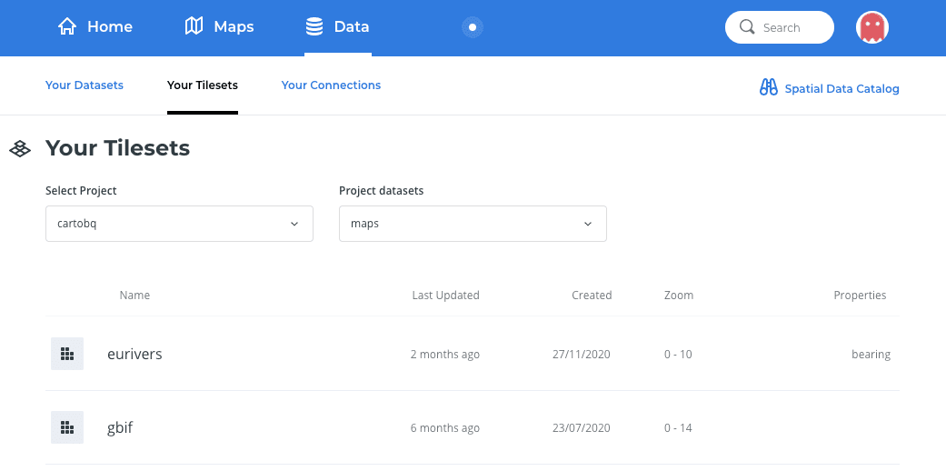
In this section you can choose the project, or pin another one and then click on the associated project datasets. You can enter your own projects or other projects that are publicly available. Check out for example:
bqcartodemos and select the tilesets project to see some public examples.
A new viewer for tilesets using deck.gl right inside the dashboard
Using our CARTO for deck.gl library we have implemented a simple tileset viewer that is fully integrated into the dashboard.
If you want to share the map with others you can do so with the embedded publishing capabilities.
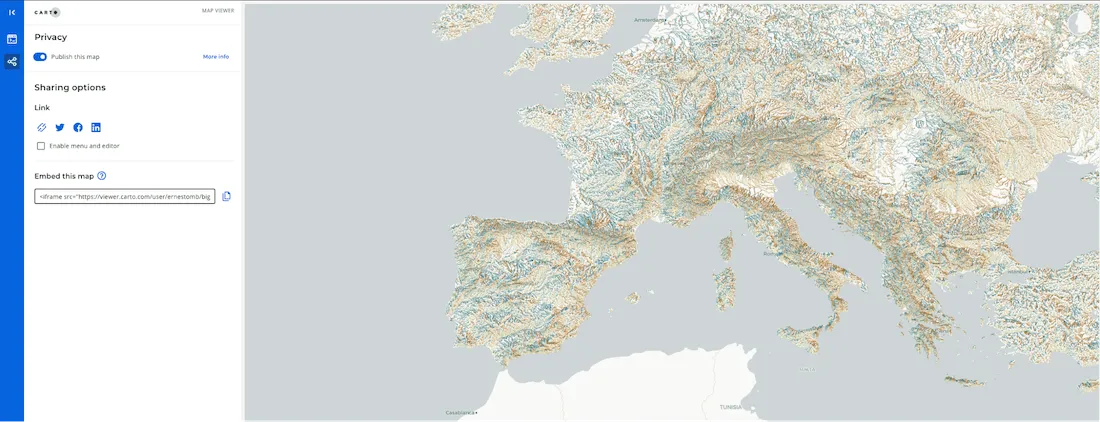
You can also embed map visualizations on any website you manage.
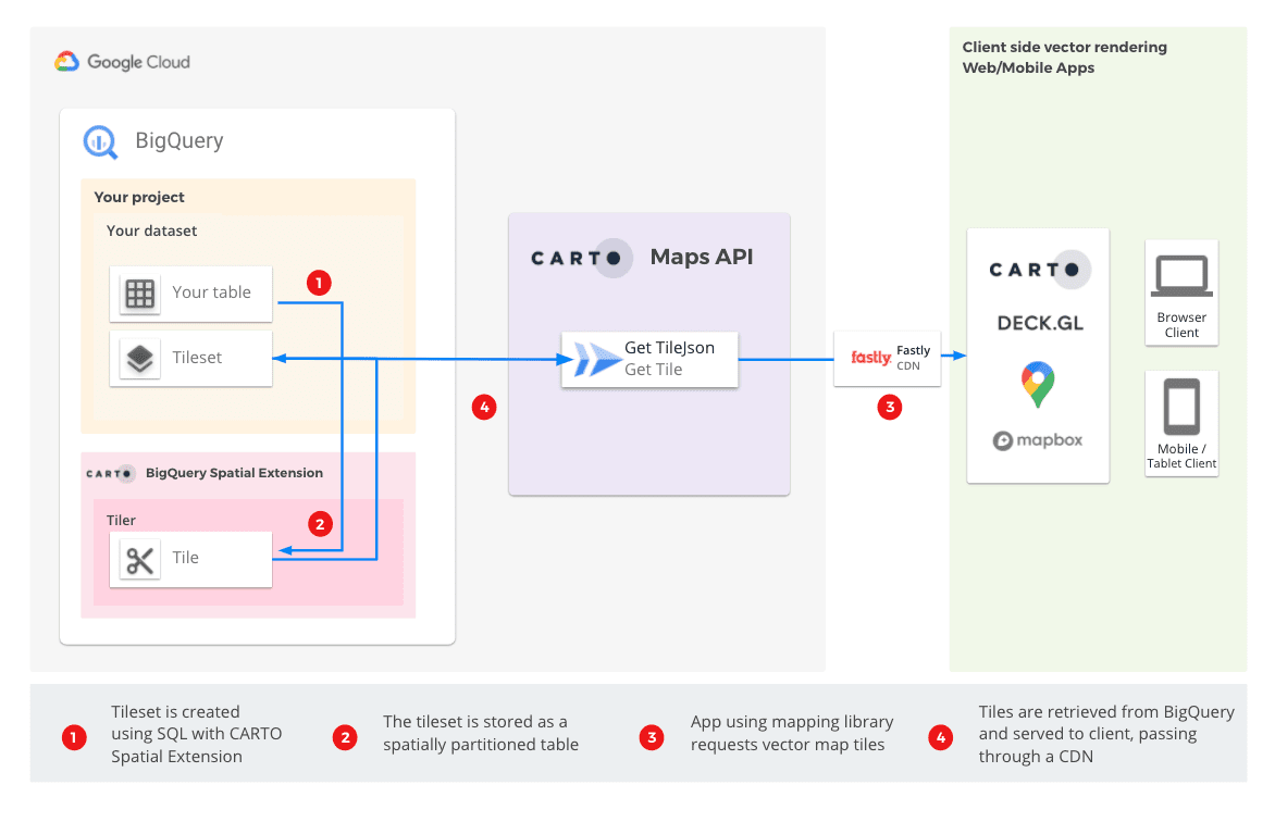
A new Maps API 2.0 that is focused on compatibility and scalability
The viewer makes use of our new Maps API 2.0 which we have built from the ground up purely for handling vector tiles. It provides support for TileJSON endpoints so you can visualize these Tilesets in any supporting library or product including our preferred Desktop GIS tool QGIS.
With TileJSON support this updated API can talk to many services and truly supports CARTO's vision to be basemap independent.

This new Maps API is fully cached through our CDN and designed to scale.
There are some great new functionalities available in this new Maps API but we will keep the details for a later announcement.
Don't let your data leave your data warehouse
If at all possible, you don't want to have to move data from one place to another to produce spatial visualizations. Unfortunately, other available tiling services will force you to do exactly that. Having to export data re-upload it, and carry out sometimes complex ETLs. Not only is this slow, but can also potentially compromise data security.
With CARTO BigQuery Tiler you can generate and serve tilesets directly on your data warehouse. Converting BigQuery into an effective spatial data mapping platform.
During our beta testing many customers have expressed that this is a key requirement for their analytical workflows and with our cloud native approach our philosophy is that everything that can be done at the data warehouse level should be done there.
Simple cost effective pricing
Pricing can become very complex when it comes to mapping and tilers. For that reason, we wanted to create a pricing approach similar to BigQuery where users pay based on the amount of computing processing done.
The unit of measurement is the GigaByte of data processed using our analytics platform, which in effect has a direct relationship with the size of the datasets being visualized.
Our pricing plans are based on easy to understand processing tiers and we are confident that we have created one of the most competitive pricing structures in the spatial analysis industry.
Spatial Analytics on BigQuery
Visualizing large spatial datasets is just one of the needs of any organization working with Location Data. You will also need to enrich your data with 3rd party location data calculate routes perform geocoding calculate spatial features perform spatial machine learning to name just a few.
That's why BigQuery Tiler is just one component on a larger toolbox we are calling CARTO Spatial Analytics on BigQuery. Stay tuned for more announcements in the coming weeks.
We believe the future of Spatial Analysis is in the Cloud, in SQL and spatially indexed. A huge step towards Cloud Native Spatial Analysis.

Start using BigQuery Tiler right now
The BigQuery Tiler our first BigQuery Spatial Extension is available from today for all users. You can sign up for a free CARTO account and get started right now.
You can check our documentation for more information, and if you have any questions or want a personal demo please reach out to us.
We can't wait to see what you build!
Ready to visualize massive datasets straight out of BigQuery?
 | This project has received funding from the European Union's Horizon 2020 research and innovation programme under grant agreement No 960401. |


