Announcing Open Source Tools Connecting CARTO and Waze


For the modern city looking to improve its mobility infrastructure and assess traffic systems modern real-time data streams are a powerful tool. A now-ubiquitous navigation tool Waze's real-time traffic data can provide key insights to urban data scientists and planners.
To make accessing visualizing and running spatial analysis on Waze data even easier the team at CARTO has created an open source CARTO-Waze connector. Once installed as a Python package the connector allows partners who have access to the Waze's real-time data stream such as members of the Waze Connected Citizens Program to have that data automatically pull into their CARTO database. The connector can be used to pull the JSON file into CARTO every two minutes for further mapping and analysis.
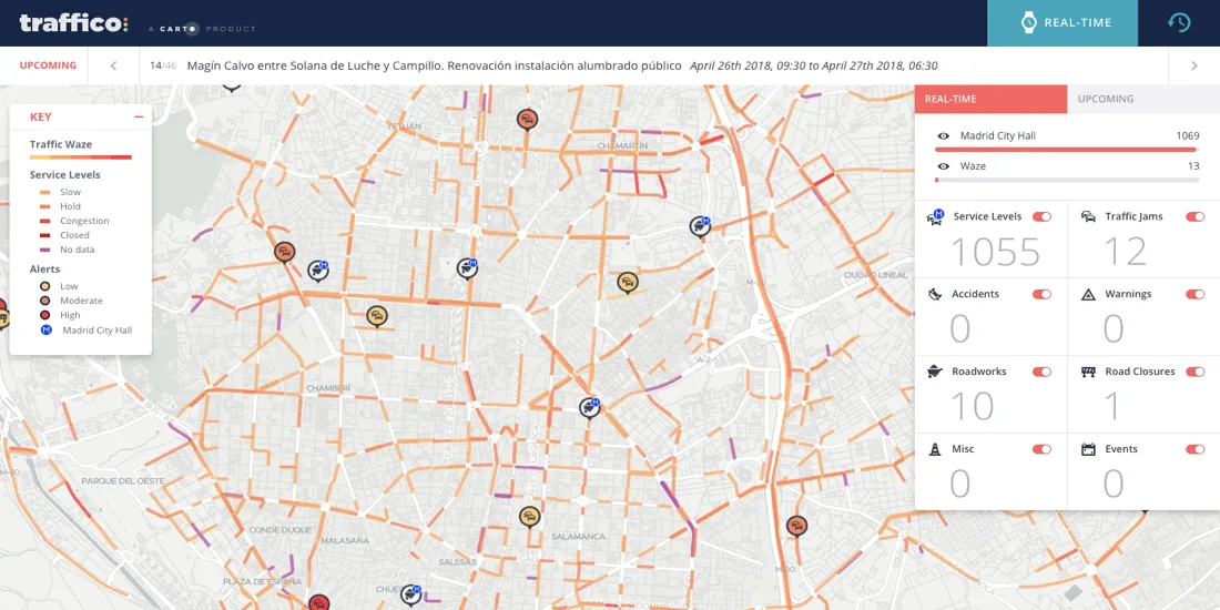
Visualizing real-time Waze data can empower decision makers planners and data scientists by showing collision hotspots helping to route emergency vehicles adjusting lane closures at possible bottlenecks like toll plazas and more. But sometimes a snapshot of the current traffic situation isn't enough.
Looking to solve mobility challenges with Location Intelligence? Learn about the latest solutions!
Historical Waze Traffic Data
For getting the wide-view of urban mobility system health historical data is invaluable. It can enable deeper analysis allow for greater outlier detection show the impact of past major events and more. And while Waze does not offer a historic data API data scientists led by the team from the Louisville Metro Government have a solution.
By developing WARP (Waze Analytics Relational-database Platform) Chief Data Officer Michael Schnuerle and his team have created an open-source cloud-based system for historic and real-time querying analysis API hooks mapping and integrations. As a Waze Connected Citizens Program partner this gives Louisville the ability to derive even greater insights as a result of their access to the Waze real-time data feed.
This open-source platform is a powerful solution for any city looking to boost their understanding of their own traffic systems. In fact at the moment following Louisville's lead 12 other cities have spun up their own WARP systems to capture the real-time data and start building their historical data sets.
A Web Interface for Historical Waze Data
The team at CARTO wanted to make sure that the cities keeping historical data using WARP would be able to easily visualize and analyze their data. To make that possible they worked with the team in Louisville to not only make sure the Waze-CARTO connector works with WARP but also has an easy to use web interface that will allow any WARP user to easily move their historical Waze data to CARTO for visualization.
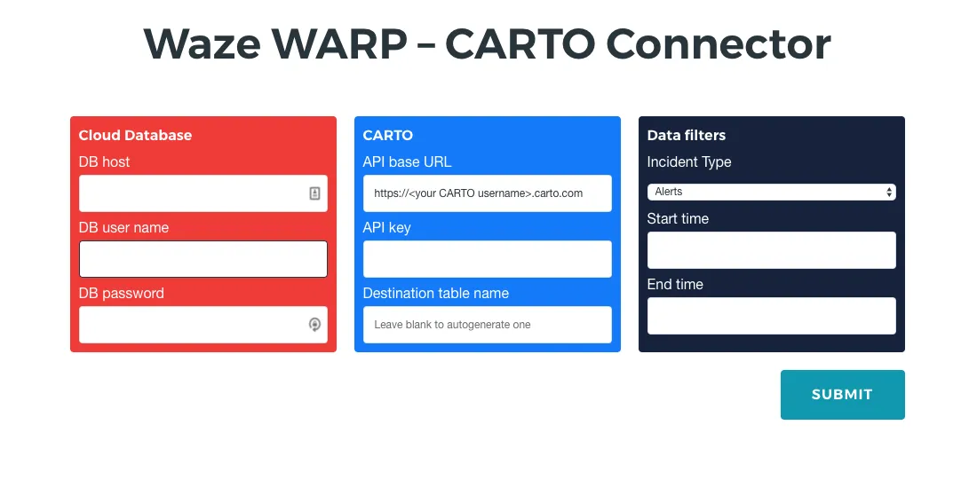
The WARP - CARTO connector currently allows users to filter the data they are pulling by incident type (Alerts or Jams) and has calendar dropdowns for date selection and users can expect improvements such as more filters in the future. This will allow data scientists transit experts and others to pinpoint the historical moment to analyze and visualize for greater insight.
Looking to gain a deeper understanding of transit and mobility in your city?
Our experts are available to help you leverage the power of location data.