CARTO collaborates on 'AsistenciaCovid19' App against Coronavirus


AsistenciaCovid19 is a new web and mobile application recently released by the Community of Madrid and created by a number of technology companies in a matter of days to help combat the spread of COVID-19.
The effective use of technology by China and South Korea has been one of the key success factors in managing the crisis in particular by being able to track the symptoms of its citizens. This helps to reduce the pressure on emergency systems and track the status of symptoms when people are taking care of themselves at home.
Importantly it also provides a method to understand the pandemic from a spatio-temporal perspective - which is precisely where CARTO brings value. Alongside extending our grants program to those requiring a visualization platform the team has been hard at work over the last five days to create both a set of apps to collect the data from citizens and a spatial backend to store the data and perform the analysis.
CARTO has collaborated with two other Spanish technology companies ForceManager and mendesaltaren with additional support from Telefónica Ferrovial and Google.
The application which has been developed in record time gives citizens access to clear advice relieving the burden on health systems and allowing authorities to increase the effectiveness of their response.
How Does the App Work?
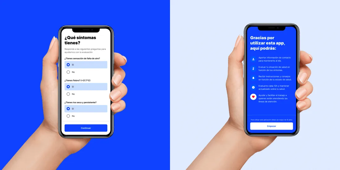
First and foremost the application allows individuals to self-evaluate symptoms to determine if further action is required. This will help to relieve pressure on the already saturated emergency communication methods and give clear recommendations for action.
As seen in the screenshots below of the soon to be released mobile version of the app citizens enter personal information including name phone number date of birth sex address postal code DNI and email (optional). They also answer some questions relating to symptoms they may be experiencing with the app advising next steps.
Since there will be a location element to the data being collected the local authorities will also be able to visualize infections on an interactive map and perform geospatial analysis to determine high risk areas. With CARTO being used in the backend to capture that information the government can see how symptoms change over time and by location allowing them to act faster in certain hotspots.
In an upcoming update the application will also allow the evolution of cases to be tracked in more detail advising on quarantine areas to determine if they are being adhered to.
All data collected will be encrypted and stored securely with citizens having complete control over its usage at all times.
Where Can I Access It?
The application is available today on the AsistenciaCovid19 website and will be available as a free download for iOS and Android users in the coming days.
AsistenciaCovid19 is available today Click here to access
Inspired by South Korea
The project initiated by the Community of Madrid and coordinated by the entrepreneur Martin Varsavsky was inspired by the success seen in South Korea who have made highly effective use of technology during the crisis.
The application will initially be available for citizens of Madrid before being rolled out to the rest of Spain. If you would like to know more about using the application or technology where you are please contact us.
It's a challenging time at the moment for everyone - both on a personal and professional level. We hope that by channeling our energy and emotion into building an application we can make a significant impact and help to contain the coronavirus through our technology.
Luis Sanz CEO of CARTO
Our founder and Chief Strategy Officer Javier de la Torre also added: "The reason we originally founded CARTO was to make data more accessible & easier to understand. When it comes to epidemiology gathering location data through an app like this at scale will allow us to use spatial modelling to support prevention & containment measures alongside the government. This is by far one of the most rewarding projects I’ve been involved with and I’m proud of how fast this remote team has worked together without a single face to face meeting to get this launched."
If you would like to hear about future developments to the app you can follow us on Twitter. If you would like to use CARTO to fight against the coronavirus - you can also find out more about our free licenses here.
CARTO Provides Free Visualization Software for Organizations Fighting COVID-19 Click here to find out more and apply