

The Quantified City: A Closer Look at Chicago's Array of Things


Data-tracking devices from wearables to time and task management applications have become a quotidian and normalized aspect of most Western societies. From Fitbits to sleep trackers -- a question like "How many steps have you taken today?" -- is regularly asked by employers and friends over drinks at Friday happy hour.
The quantified self is not a new concept.
What is new is the idea of a quantified city. Cities are collecting massive quantities of data with the implementation of sensor-based technologies. However most of that data which is open sits in silos rarely leveraged by agencies departments and organizations for the benefit of citizens.
Chicago is the latest city to crack the syntax of smart cities and hack the Internet of Things. Instead of focusing on data to quantify individual productivity and activity the city has partnered with researchers to analyze sensor-collected data to measure the City by the Lake's "fitness."
Dubbed the Array of Things (AoT) a network of interactive modular sensors is collecting new streams of data on environment infrastructure and activity. This hyper-local open data can help researchers city officials and software developers study and address critical city challenges such as flood prevention traffic safety air quality and availability to civic services.
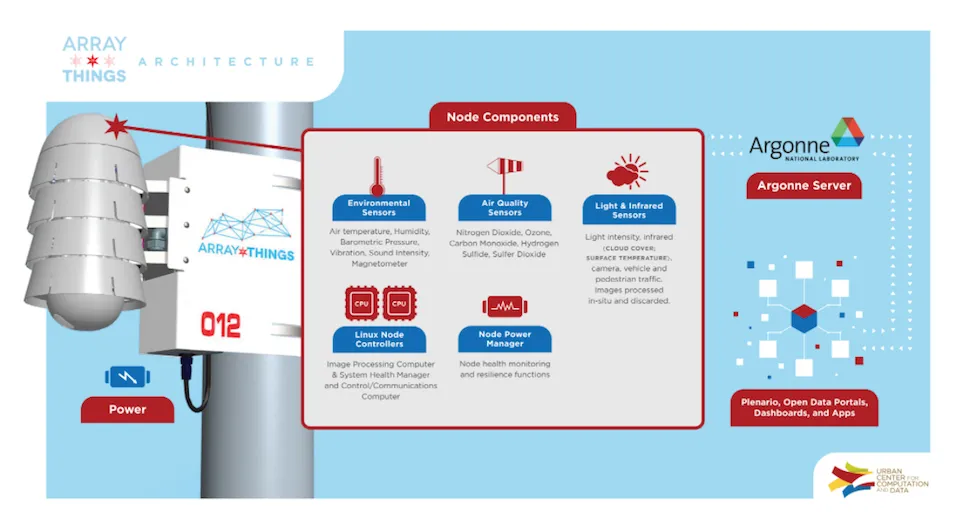
Source: http://arrayofthings.github.io/images/2016-diagram-lg.jpg
Chicago's initiative is a perfect symbiosis of resources from the University of Chicago Argonne National Laboratory and the School of the Art Institute of Chicago. The development and research groups collaborate with AT&T internet service providers and are backed by a $3.1 million grant from the National Science Foundation.
A projected 500 sensors will be installed along Chicago streets by the end of 2018.
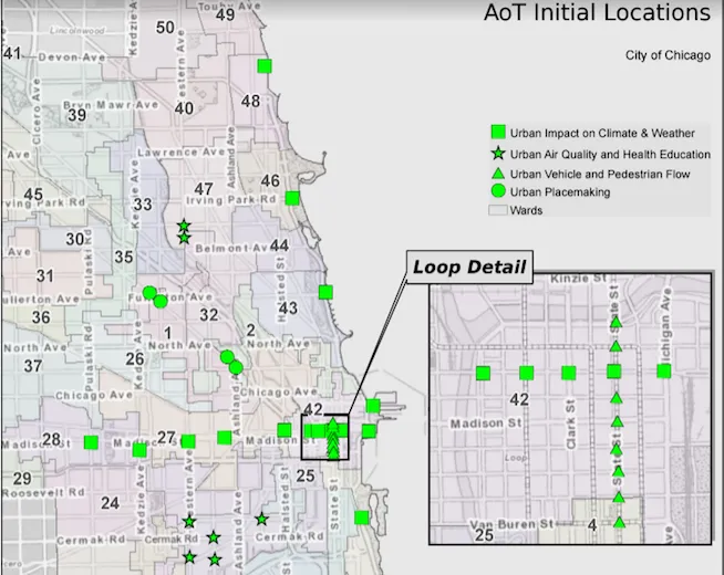
Source: http://arrayofthings.github.io/images/node-locations.png
Researchers working on the AoT believe collecting data -- including readings of air quality and pollutants light noise people's movements and other information -- will help city officials better understand the urban environment. There are hopes that the data which will be made publicly available through the city's data portal will lead to innovation as well as better public services.
But beyond making cities more liveable and learning from an array of technologies like the University of Chicago's Urban Lab's location application the project integrates crowdsourced data distributing the responsibility of livability onto all residents.
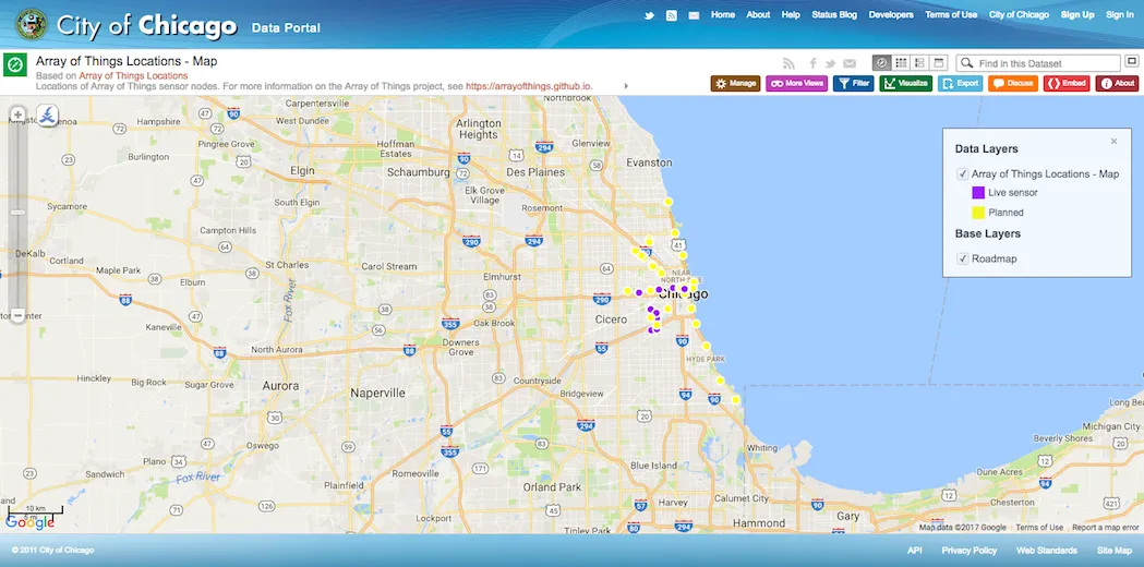
Source: https://data.cityofchicago.org/Environment-Sustainable-Development/Array-of-Things-Locations-Map/2dng-xkng
For Chicago once completed the Array of Things will make it a leader in smart city innovation. The programmable nodes are designed to host a variety of sensors and devices providing an urban-scale testing ground for smart city technologies such as new communications or information systems.
"Urban sensing -- collecting and using data from sensors in public urban spaces -- is essential to the next generation of data science and to improving city service delivery " said Brenna Berman Chicago Department of Innovation and Technology Commissioner and Chief Information Officer.
The data from sensors is available in standardized form accompanied by latitude and longitude information affords communities and interest groups the opportunity to identify potential areas to improve the urban experience.
The AoT will be the central nervous system of cities. {% include icons/icon-twitter.svg %}Share it on Twitter
Chicago's use of location intelligence is just one way that IoT implementation is being produced and grounded in different contexts proving the ways that the concept travels and evolves.
To learn more about how location intelligence complements existing municipal infrastructure the Array of Things IoT technologies and civic technology research sign up for the CARTO 5 a bi-weekly curation of the best in location analysis and intelligence. Want to know how you can build a city of the future? Check out our 4-Step Framework for Smarter Cities.
Happy Data Mapping!


