Extend Databricks Genie Code with CARTO's Agentic GIS platform


The way GIS and analytics teams work is changing quickly, and the agentic turn in analytics platforms is what is driving it. Instead of operating tools, people describe the outcome they want and the agent does the heavy lifting. For example, some teams are already using Databricks Genie Code for data work directly in the lakehouse, and CARTO for Agents for their geospatial work wherever their agent runs. Agentic GIS is no longer a preview of the future; it is how a growing share of spatial analysis gets done.
Recently, Databricks has been scaling up its native spatial capabilities: spatial data types, a library of spatial SQL functions, and basic map visualizations inside AI/BI dashboards. That provides a solid basis to cover part of the geospatial analysis directly in the lakehouse, but it is not always where the spatial work ends.
Some projects still call for more specialized capabilities, and that is the ground a cloud-native geospatial analytics platform like CARTO covers. Deeper spatial analysis through an extended analytics toolbox. Wide geospatial rendering and styling options, scaling to millions of features while still looking sharp. Collaborative map building. Geospatial AI Agents wired into maps and workflows. Tailor-made geospatial web applications with advanced capabilities. All of it while still running natively on Databricks: the SQL executes in your own compute against Unity Catalog tables and nothing is copied out to intermediate geospatial databases.
For teams already using both platforms, the friction left is having to switch between them. The CARTO MCP Server removes it, bringing CARTO’s geospatial tools into the agentic platform your teams already work in. Within the Databricks ecosystem, Genie Code is the natural place for that. It runs on Unity Catalog, so it inherits the governance you already have, and it is built to be extended with MCP servers and Agent Skills, the two things specialized spatial work needs: the tools to do it, and the methods to do it well.
Turning Databricks Genie Code into a geospatial agent with the CARTO MCP Server
Connecting CARTO and Genie Code can do the spatial half of the job itself: building maps, revising them, designing an analysis, authoring the workflow that runs it, and looking after your CARTO account. The governance you already have holds. Calls arrive in CARTO as your authenticated user, are logged and traceable, and the SQL runs natively in your lakehouse against Unity Catalog tables, under the permissions that user already carries on both sides.
Ask for the map, then shape it. Describe what you want and the map is built in CARTO, ready to open or share. From there you keep going in words: a different variable, a coarser classification, a layer dropped, a different style, etc. Analysis works the same way. Settle the method with the agent, then have it build a CARTO Workflow, leaving a pipeline that can be opened, reviewed, forked and scheduled, and that runs identically every time rather than always depending on SQL queries written by an agent at the moment of asking.
The long jobs stop being deferred. A map for every region you operate in. The whole set refreshed when new data lands. One scoring model rerun with a different weighting per business unit. None of that was ever difficult, only long, which is why it kept sliding down the list. The agent gives the last one the same attention as the first.
Spatial analysis reaches further into the company. Someone who has never opened a mapping tool can ask a spatial question and act on the answer. A network planner asks which service areas overlap. A risk analyst runs the exposure workflow and asks what moved since the last run. They sign in once with their CARTO account, and after that the analysis comes to them.
Administration, available in the same window. The CARTO interface remains where platform work lives. What changes is that the same operations are exposed as tools, so an administrator can ask the agent to review connections, add people, rotate credentials, or summarize what has been built and by whom.
Governed and secure by design. Nothing is copied out. CARTO is cloud-native, so every query runs inside your own lakehouse. The MCP tools call the same CARTO APIs that sit behind any of the other platform tools, carrying the signed-in user’s token, so existing roles, permissions and row-level controls apply with nothing new to configure. Activity Data records each action next to the platform that made it.
Connect the CARTO MCP Server to Databricks Genie Code
Setup runs in the Databricks UI and takes four steps. You will need a Unity Catalog workspace in a region that supports Model Serving, and either a CARTO OAuth client for the full tool surface or a CARTO API access token for browsing and querying.
Register CARTO as an MCP service. In Databricks, go to AI Gateway > MCPs and connect an existing MCP server: pick a catalog and schema, name it, paste the CARTO MCP Server URL, and choose how to authenticate.
Load the tools you want. Choose Create & load tools, and use a glob filter if you prefer to expose only part of the tool surface.
Add the Agent Skills to your workspace. Create a Skills folder inside the .assistant folder of your Databricks workspace and import the CARTO skills bundle into it.
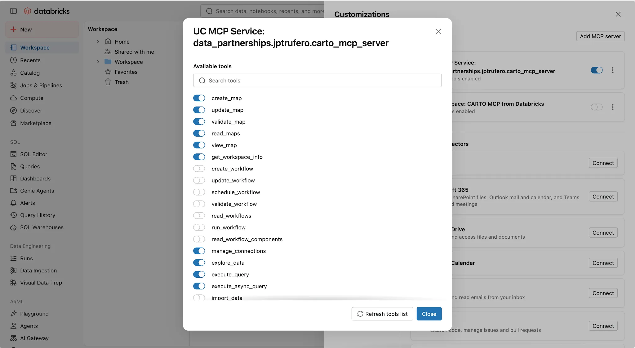
Turn both on in Genie Code. Under Customizations > Connectors, add the CARTO service and enable the tools you want. Then under Customizations > Skills, point at the folder you just created and enable the skills your teams will use.
Full instructions are available in our documentation.
See it in action
Geocoding, isolines, and routing in Genie Code are just an MCP tool away
We pointed Genie Code at a table of customer addresses in Unity Catalog and asked it to geocode them into a new table, and then map the result in Builder. The CARTO MCP Server exposes CARTO’s location data services, geocoding, isolines and routing, as MCP tools that the agent calls directly on the tables already in the catalog. There is no extract, no separate service to wire up, and no geocoding SQL to write: the agent picks the right tool, writes the results where you asked, and hands back a link to the map.
Using Genie Code and CARTO to analyze retail store performance
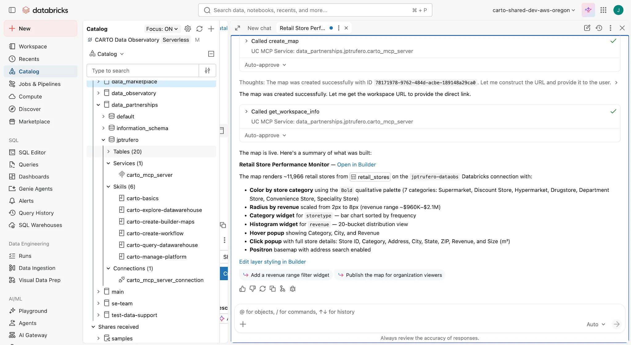
Next we asked for a map to monitor store performance, built from a retail table in the same catalog, with stores colored by category and sized by revenue, a category widget, a revenue histogram, and popups carrying the details that matter per store. Working through the MCP Server and the map building skill, the agent took care of the whole map building work, made the right cartographic calls that usually take a round of review, and returned a link to a map in CARTO Builder that can then be shared or published.
Using Genie Code to publish a geospatial analysis workflow as a reusable tool
Then we asked the agent to turn a piece of analysis into something permanent: isolines around each geocoded customer, with travel range and transport mode as input parameters, polyfilled into H3 cells, enriched with population data, and aggregated per store. The agent authored it as a CARTO Workflow, which compiles down to a native Databricks workflow running in your own compute. That distinction matters. Instead of an answer that exists only in a chat transcript, you get a pipeline anyone can open and inspect, rerun with different parameters, schedule, call as an API endpoint, or publish as an MCP tool for other AI agents to use.
Make the geospatial workflows built with CARTO available across your teams via Genie Code
Finally we ran one of those published workflows the way a colleague would, asking Genie Code to calculate population within 3 km of our stores in Texas and return the updated map. Nobody has to know which tables are involved, how the analysis was built, or what the parameters are called: the agent finds the tool, runs the approved analysis exactly as it was authored, and explains what came back in the same conversation. The same applies to maps already in your CARTO account, which the agent can search for and surface on request.
Start today!
If you are a CARTO customer, you are a couple of minutes away. Register the CARTO MCP Server in your Databricks workspace, add it to Genie Code with the Agent Skills alongside it, and ask for your first map. The tools give the agent access; the skills give it judgment.
Not sure where to start, or not a customer yet? Request a demo and we will show you how to turn Genie Code into your geospatial assistant.
Frequently Asked Questions
What is the CARTO MCP Server for Databricks Genie Code?
It’s an external MCP service that lets Databricks Genie Code call CARTO’s platform — building and revising CARTO Builder maps, running geospatial analysis, and publishing CARTO Workflows — with calls arriving in CARTO as the authenticated user and the underlying SQL running natively in your own lakehouse against Unity Catalog tables.
Does connecting CARTO to Genie Code move or copy my data?
No. CARTO is cloud-native, so every query the agent triggers runs inside your own Databricks compute against Unity Catalog tables. The MCP tools call the same CARTO APIs that sit behind the rest of the platform, carrying the signed-in user’s token, so existing roles, permissions and row-level controls apply with nothing new to configure.
What do I need to set up the CARTO MCP Server in Databricks?
You need a Unity Catalog workspace in a region that supports Model Serving, and either a CARTO OAuth client for the full tool surface or a CARTO API access token for browsing and querying. From there you register the CARTO MCP Server under AI Gateway > MCPs, load its tools, add the CARTO Agent Skills to a Skills folder in your workspace, and enable both under Genie Code’s Customizations.
What do the CARTO Agent Skills add on top of the MCP Server?
The MCP Server gives the agent the tools to build maps, run analysis, author workflows and manage a CARTO account. The Agent Skills give it the judgment to use them well — which tool fits a given request, and how CARTO work is usually done.