Geospatial Analysis in Claude with the CARTO MCP Server



Not so long ago, ask any spatial question and it would turn into a whole project. Export the data, open a specialized tool, wrangle with file formats and projections, style the layers, screenshot the result into a deck, and by the time anyone saw it the question had moved on. The analysis was rarely the slow part. Getting the data in the right place and the tool-shuffling around it was.
That is the part agents take over. You stay on the question, the agent handles the mechanics. CARTO for Agents opened the platform to agents, and the CARTO MCP Server turned all of it into tools any MCP client can call: maps, workflows, apps, geocodes, routes, and access to third-party data. The people who know the data best stop queuing for someone else’s calendar, and the specialists get their attention back for the questions that genuinely need it.
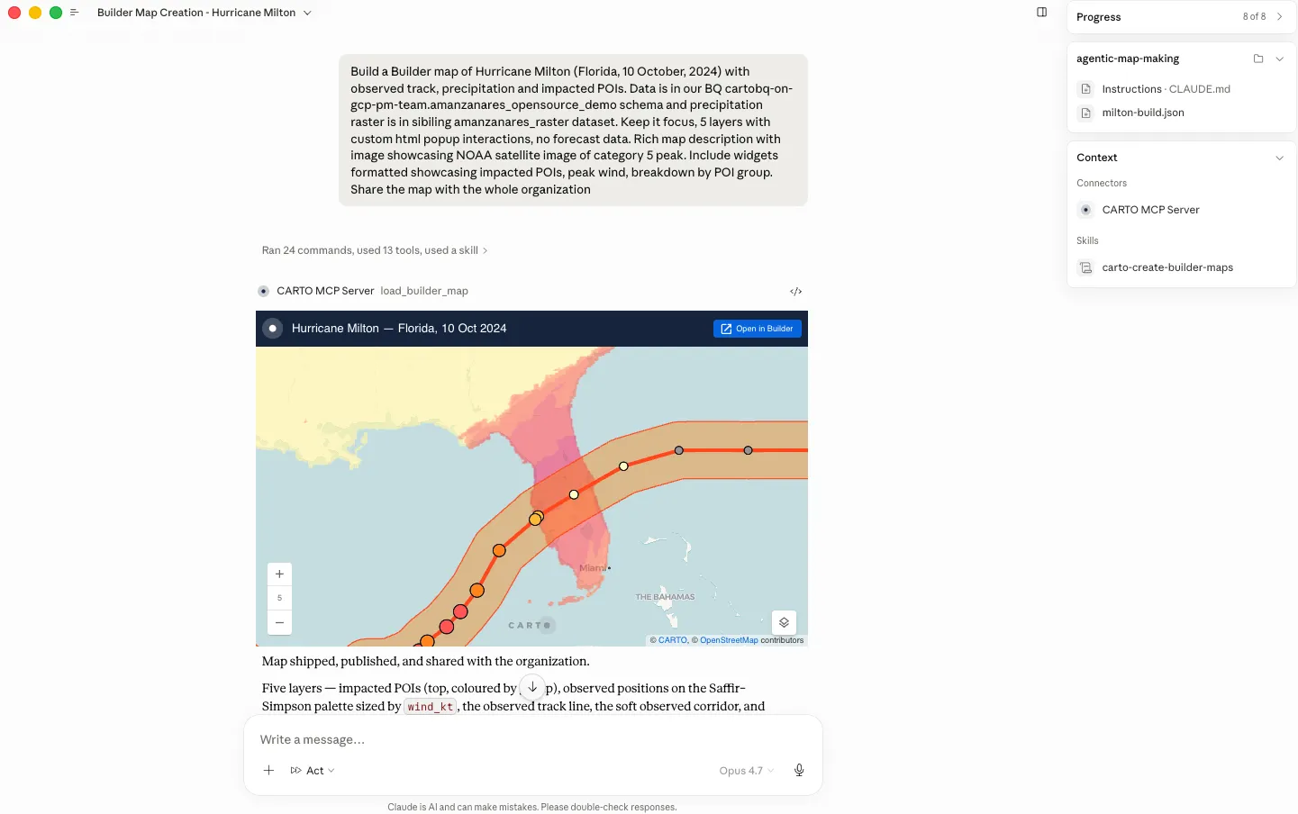
Claude is a natural fit for this kind of work. The models are exceptionally strong at the kind of reasoning analytics demands: holding a multi-step method together, questioning a result that looks wrong, and explaining what they did. Claude also supports MCP Apps, so a CARTO map renders inline: you see it in the same conversation where you asked for it, and revise it in your next message. The result is a full loop, from question to map to revision, in one place.
Turning Claude into a geospatial agent with the CARTO MCP Server
Connect the MCP Server and Claude stops talking about spatial analysis and starts doing it: making maps, editing them, rebuilding them for a new region, designing analyses, running them, and administering your account. The controls do not change. Claude acts as your authenticated CARTO user, each call is logged and traceable, and the queries run natively in your connected data warehouse under the permissions and data access rules you already have.
Ask for a map, then keep going. The first version arrives in the conversation. From there it is a dialogue: recolor by a different field, drop a layer, tighten the classification, rewrite the popup, zoom to the region you actually care about. Analysis follows the same rhythm, and it is worth pausing on how it ends. Work out the method with Claude, then ask for it as a CARTO Workflow. You are left with a pipeline that can be opened, reviewed, forked, and scheduled, giving the same answer every run instead of a query improvised on the spot.
Volume stops being a reason not to. A map for each of your 50 markets. A whole set refreshed when the new quarter lands. The same analysis rerun with a different radius, a different threshold, a different cohort. Work like this was never hard, only long, which is why it kept sliding down the list. Claude treats the last one as carefully as the first.
Everyone gets to ask. The person with the question no longer needs the tool or the training. A merchandiser asks which stores overlap and gets the map. A claims lead runs the exposure workflow and asks Claude to walk through what it returned. They sign in once, and after that the analysis comes to them.
Platform housekeeping, in the same thread. Connections, users, credentials, an audit of what has been built and by whom: these are tools too, so the administrative work happens in the conversation rather than in another tab.
Governed and secure by design. Your data does not move. CARTO is cloud-native, so every query runs in your own warehouse. Claude reaches CARTO through the same APIs that sit behind Builder, using your token, which means your roles, permissions, and row-level security apply as they already do. Activity Data logs each action with the platform that made it, and the choice of model stays yours.
Connect the CARTO MCP Server to Claude
Setup is a URL and a sign-in, and it works the same way in Claude on the web and in the desktop app:
- Open Settings > Connectors and choose Add custom connector.
- Name it CARTO, paste the CARTO MCP Server URL, then click Add and Connect.
- Sign in with your CARTO account and approve access. If your organization uses SSO, sign in through the SSO login URL from your CARTO Workspace.
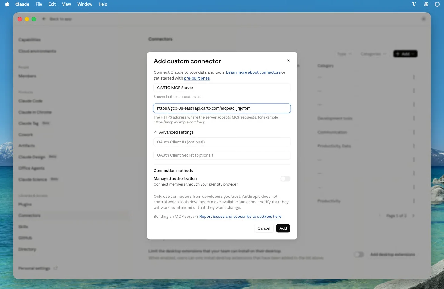
There is no OAuth client to create or register on either side, so nothing has to go through your platform team first. Claude connects over OAuth, so the full tool surface is there from the start: browsing connected data, creating and editing maps, authoring and running Workflows, geocoding, routing, and administration.
One thing worth doing straight after connecting: ask Claude which CARTO tools it now has, and which connections and tables it can see. It is the fastest way to confirm that the permissions being applied are the ones you expect.
Full instructions are available in our documentation.
See it in action
Using Claude Cowork to analyze which buildings fall outside telco network coverage
In this example, we pointed Claude at cell tower location data in Denver and the city’s building stock, and asked the agent to build the following analysis as a CARTO Workflow: a 1km service radius around each LTE tower, then the buildings falling outside all of them.
Rather than reporting back a flat list, the agent broke uncovered buildings down by type so Medical, Public, and Commercial sites are flagged, and measured each critical building’s distance to its nearest LTE tower, separating marginal gaps from genuinely remote ones.
Claude laid out the plan before running anything and saved the workflow, so the same pipeline reruns as new towers come online, and any analyst can open it, audit the logic, or extend it with new rules.
Using Claude Cowork to map telco network coverage gaps
Picking up from the previous Denver cell tower analysis, we asked Claude to map the result — not as a data dump, but as something that could go straight into a capex review meeting.
Working through the MCP Server and the carto-create-builder-maps skill, it built the visual hierarchy the decision needs: LTE service areas hatched lightly so they read as coverage rather than blocks, uncovered critical buildings prominent, garages and sheds faded back as noise, and towers symbolized so the old CDMA sites — the upgrade candidates — are distinguishable at a glance. Popups are custom HTML rather than a field list, with a red or amber badge on distance to the nearest tower.
CARTO CLI: ship spatial apps and analysis workflows with Claude Code
Some work needs more than a conversation. It needs a repository, a terminal, files on disk, and a build step, which is where a coding agent such as Claude Code earns its place: vibe coding and shipping a spatial app, or iterating on a complex analytical pipeline until the method holds up. For that, CARTO pairs the CARTO CLI with Agent Skills, playbooks that teach an agent how CARTO work is done and when to reach for the CLI rather than the MCP Server. Install the CLI with npm install -g @carto/carto-cli, and the docs cover the rest of the setup.
From there, Claude Code can build and ship a spatial app on your data, scoping its credentials to only what the app needs, or work through a serious analysis such as site selection or distribution center placement: exploring the warehouse, validating the design against it, and leaving behind a versioned CARTO Workflow that anyone can rerun.
Start today!
If you are a CARTO customer, you are just a couple of minutes away. Add the CARTO MCP Server as a connector in Claude, sign in with your CARTO account, and ask for your first map. Pair it with the Agent Skills so Claude brings geospatial judgment as well as access.
Not sure where to start, or not a customer yet? Request a demo and we will show you what your own data looks like from inside Claude.