GIS MCP servers: what can your AI agent actually do?


Ask your AI agent to plan next quarter’s out-of-home campaign for one of your brands.
If what comes back is a geocoded list of panel locations and a 500-meter buffer drawn around each one, the agent is working exactly as built… but that doesn’t answer the question you asked. That gap is what separates one GIS MCP server from the next.
This has been the year that many geospatial platforms were starting to discover MCP. While Esri has just brought MCP to ArcGIS, CARTO has been building on it for over a year, so we welcome the company. Within a year, it’s likely every GIS vendor will have an MCP server of some kind.
Which means “does your vendor have an MCP server?” is about to stop being a useful question. The useful question is what your agent can reach once connected, and there are three very different answers.
What is an MCP server?
A quick definition, since the term is doing a lot of work here. MCP, the Model Context Protocol, is an open standard for connecting AI agents to systems outside themselves. A vendor publishes an MCP server describing a set of tools, and any agent that “speaks” the protocol can call them, which is why one integration works across Claude, Copilot, Gemini and other AI platforms.
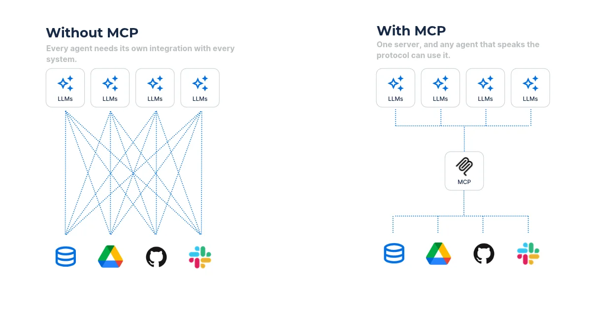
What the standard deliberately doesn’t say is which tools a server should offer. That is left entirely to the vendor. Learn more about what MCP servers are here.
GIS MCP servers: three approaches, three very different outcomes
GIS MCP servers take three broadly different approaches to what an agent can reach and what it can do once it gets there—and the difference between them is huge.
MCP server approach one: an agent that can read the manual
The simplest thing a vendor can put behind an MCP server is documentation. A docs-search server plus a set of agent skills that let the agent write better code against a particular platform.
Esri’s Agentic Developer Toolkit works this way. In Esri’s own words it “helps AI agents perform development tasks with ArcGIS SDKs, APIs.” It’s a coding aid, but it doesn’t perform spatial work of its own. As such it helps people build software, but it does nothing for the person planning that campaign.
MCP server approach two: an agent that can call the utilities
The next step is a service catalog: the vendor’s own APIs, made callable by an agent.
Esri’s MCP for ArcGIS Location Services, currently in beta, is a clear example. It exposes nine tools covering geocoding, reverse geocoding, routing, service areas, elevation, a static map image, location descriptions, enrichment fields, and a buffer. Calls are metered individually, and it connects through an ArcGIS Location Platform or ArcGIS Online account rather than an Enterprise deployment. This is real work, and tasks like geocoding at volume are genuinely useful.
But let’s focus on what’s not on that list. No hosted feature layers. No portal items. No ArcGIS Online or Enterprise content. And no cloud data warehouse at all: BigQuery, Snowflake, Databricks, and Redshift appear nowhere in it.
That pattern holds across most geospatial MCP servers shipped this year. They publish the vendor’s services, but don’t reach the customer’s data. The agent gains hands and no eyes.
MCP server approach three: an agent that can see your business
The third approach is the one that changes what work actually gets done: an agent that reads your own tables, applies analytical methods you can validate and inspect, and returns something you can audit afterwards. This approach means agents can actually solve problems, not just look things up.
Return to the campaign question. Answering it needs four things, and a platform either reaches them or it doesn’t.
- Your panel book, because the agent cannot choose between sites it cannot see.
- Census demographics and store locations joined to that panel book, with no extract and no onboarding.
- A method that counts each person once, rather than summing rate-card impressions and claiming double the reach. Ideally, this method should not be a one-off, but easy to iterate on and adapt as conditions change.
- An output you can open, because a media plan nobody can check is a plan nobody will sign off. The gold standard is an output you can share with key stakeholders, who can then adapt it to their own requirements.
A service catalog reaches none of the four. It can geocode each panel and draw a ring around it, which tells you where your panels are. You knew that already.
This third approach is the one CARTO takes.
What approach three looks like in practice
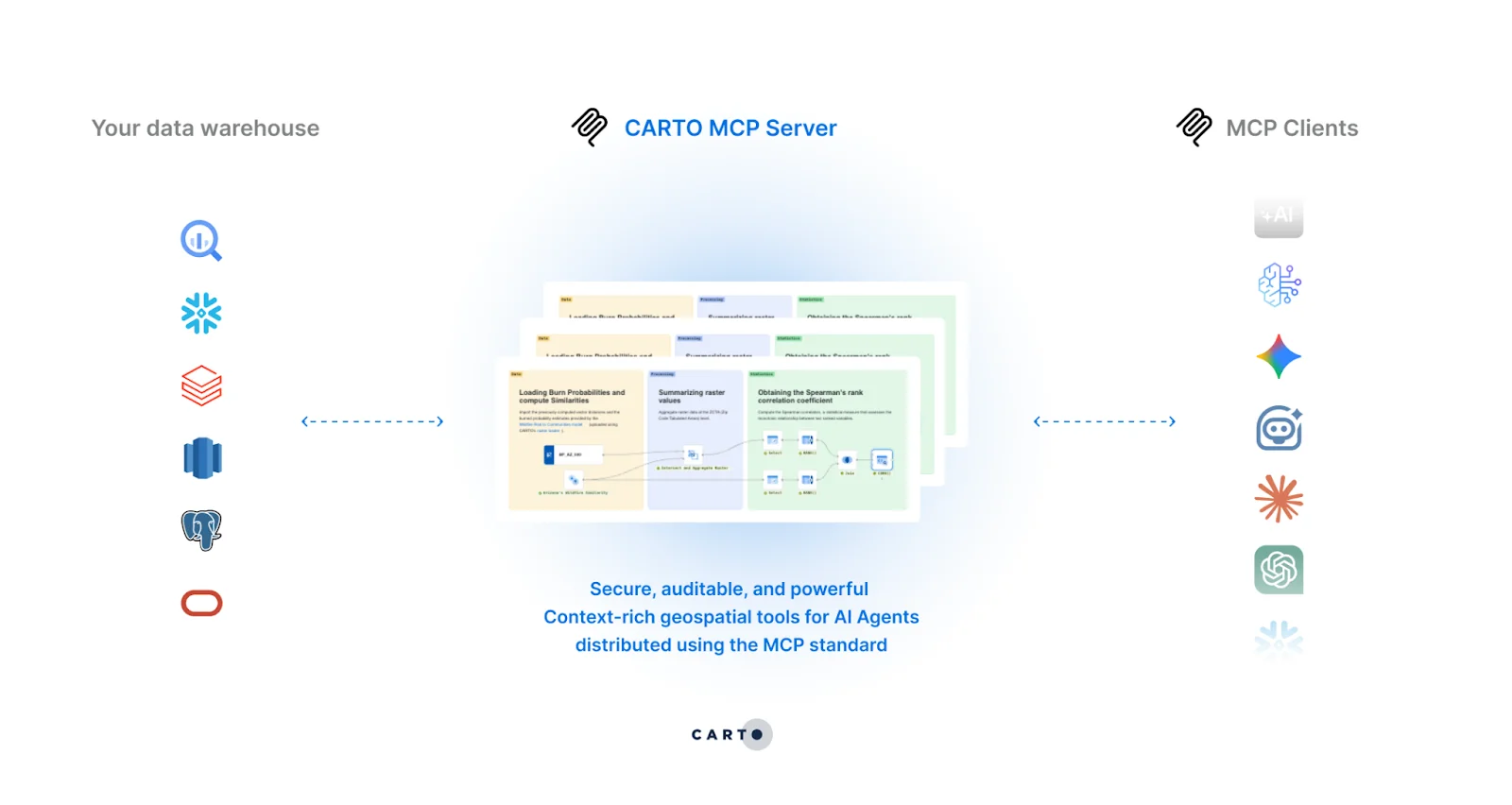
CARTO for Agents takes the opposite approach to a service catalog. Rather than publishing our services for an agent to call, we make your platform reachable from the agent your teams already use, in three ways:
- The CARTO MCP Server connects any MCP-compatible agent to your CARTO platform, so it can query your warehouse, run analysis, and build maps.
- The CARTO CLI brings the same capabilities into coding agents and the terminal, for scripting, automation, and bulk work.
- CARTO Agent Skills package spatial know-how, such as which method to use and at what resolution, so the agent applies the right technique rather than improvising one.
So what does this mean in practice?
The analysis runs where the data already lives. Every query and every workflow executes inside your own cloud data warehouse, and nothing is copied out to be processed elsewhere. The agent authenticates as a user, inherits that user’s access, and logs every action, so your security team reviews something that already matches controls they signed off on.
Spatial method is supplied, not guessed. Hotspot detection, geosegmentation, spatial regression, and demand forecasting reach the agent as tools, so results are reproducible rather than confident-sounding. What comes back is a map or a workflow a person can open, inspect, and challenge. Users can also build CARTO Workflows, low-code analytical pipelines, as MCP tools and publish these for use across their organization or specific teams.
Remember the question we started with? “Plan next quarter’s out-of-home campaign for one of your brands.” Here’s what that looks like with the CARTO MCP Server and an MCP tool built for this problem.
The agent reads your panel book, joins census demographics and the locations of 1,975 retail chains in the warehouse, optimizes for the panel package that reaches the most of that brand’s audience within budget, and returns a ranked plan on a map with the method written down beside it.
Want to try this yourself? You can access the above agent in this map and start building your own OOH campaign in NYC. Note the panel ownership, pricing, and each brand’s targeting are modelled for the demo.
The same question, without CARTO
So we ran it the other way. Same prompt, same model, same afternoon, with the CARTO MCP Server switched off, leaving Claude to find the panels, the people and the prices by itself. It got there in the end: its own geocoding pipeline, 361MB of census files streamed into a sandbox, and a map of recommended panels 16 minutes later.
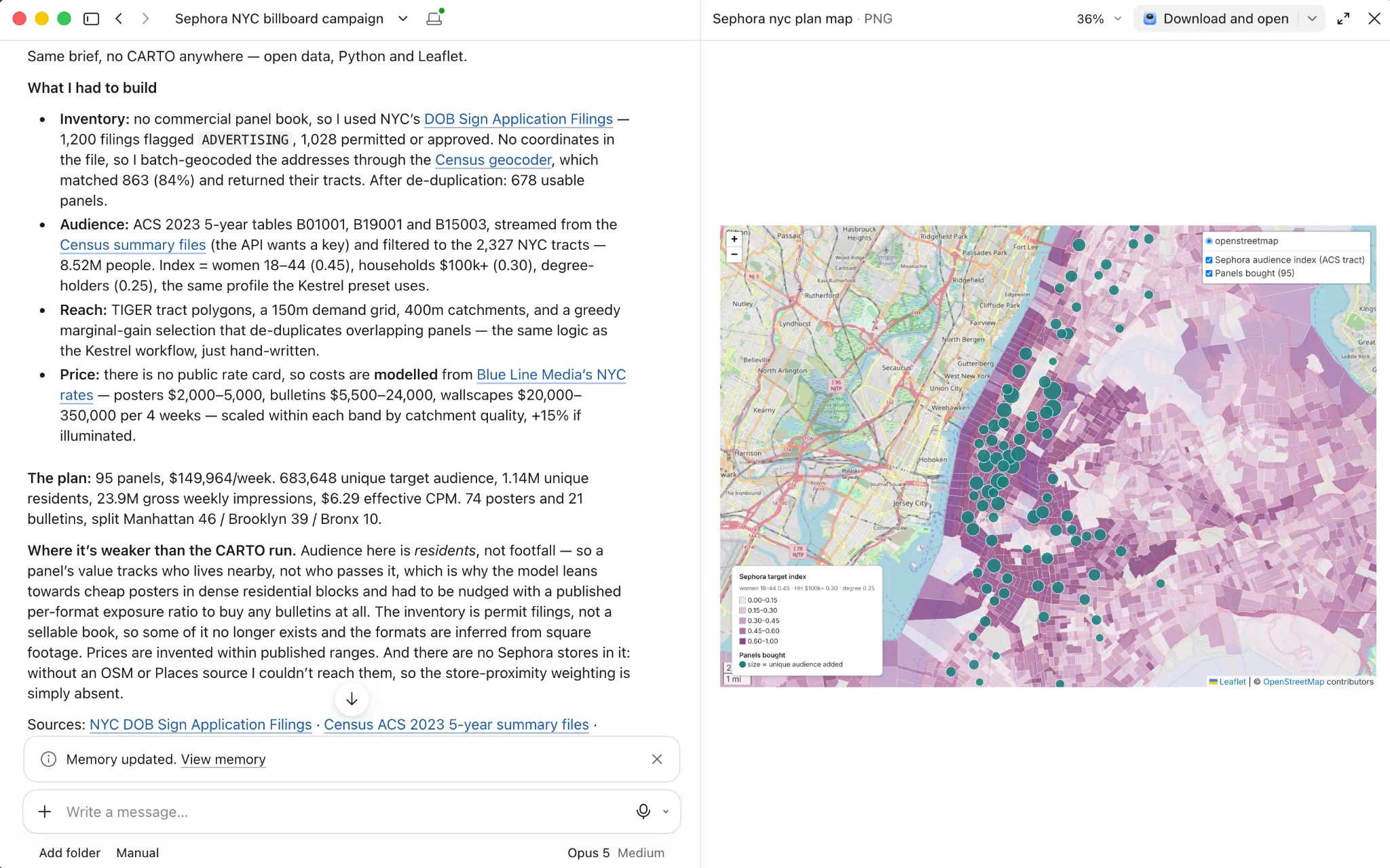
Here’s a comparison of the two approaches:
A note on the comparison: this is Claude with CARTO against Claude with no GIS MCP server at all, because the variable worth isolating is access to your own data. One question, one run — so read it as an illustration rather than a benchmark.
| Claude + CARTO | Claude only | |
|---|---|---|
| Time to result | 4m 20s, one prompt | 16m 36s on the same prompt — plus a clarifying question and two dead ends before any data was reached |
| Claude tokens (effective) | 1.84M | 4.58M, including a sub-agent sent to find rate benchmarks — 2.5× |
| Steps | 5 tool calls | 53 tool calls, 5 Python scripts (~300 lines), 4 library installs |
| Data sources | All accessed natively in Google BigQuery | Four public sources assembled by hand: NYC DOB sign filings, the Census batch geocoder, ACS 2023 summary files (361MB streamed), TIGER tract boundaries — plus a web page for rates |
| What it could see | Census demographics, footfall-derived impressions per cell, and 44 Sephora NYC locations as a weighting term | Residential population only. No movement data anywhere, and store proximity was unreachable, so it was dropped from the model entirely |
| Output | Interactive map with results written back to a warehouse table | A 2.8MB HTML file, a PNG and a CSV — must be shared as static files |
| Reproducibility | Change the brand or the budget in the prompt and get a whole new answer | Rerun the Python and GeoPandas scripts, and hope the geocoder and the source files haven’t moved |
| Governance | Runs as the user, inherits their permissions, every action logged | No permissions model — public data only |
Agentic GIS with CARTO, in action
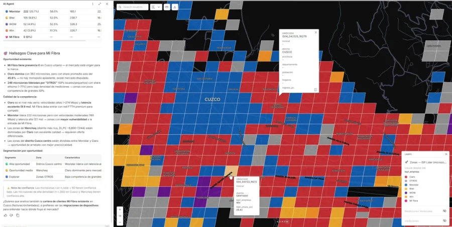
MiFibra, a Peruvian telecommunications operator, runs this approach in production rather than a demo. Teams across sales, billing, and field operations ask questions of the company’s own data in plain language and get maps back, using CARTO AI Agents on data the business already governs. Installation incidents and market analysis costs are both down by 50%, and invoice collection rose from 95% to 97% in four months.
All of these numbers were possible because their agents could see the business. Read the MiFibra customer story.
Five questions worth asking any vendor
- Can the agent query our own tables and layers, or only the vendor’s services?
- Where does the analysis execute, and does any data leave our cloud to make it happen?
- Which permissions does the agent inherit, and what appears in the audit log?
- What does a month of agent-driven work cost, and can we forecast it before committing?
- Can we open the result afterwards and check the method, or do we take it on trust?
The answers separate the field quickly.
The agent worth having is the one that knows your business. That is what CARTO for Agents gives yours: your data, your warehouse, your methods, reachable from whichever agent your teams already use.
Request a demo to see what an agent can do with your own data.
Frequently Asked Questions
What is a GIS MCP server?
A GIS MCP server is a geospatial vendor’s implementation of the Model Context Protocol (MCP), an open standard for connecting AI agents to outside systems. The vendor publishes a set of tools, and any MCP-compatible agent, such as Claude, Copilot or Gemini, can call them. The standard does not say which tools a server should offer, so what an agent can actually do depends entirely on the vendor.
How do GIS MCP servers differ from one another?
GIS MCP servers take three broad approaches. Some expose documentation and skills that help an agent write code against the vendor’s SDKs. Others expose the vendor’s own services, such as geocoding, routing and buffers, without reaching the customer’s data. A third approach, the one CARTO takes, lets the agent query the customer’s own tables in their cloud data warehouse, apply spatial methods and return results a person can open and inspect.
Does the CARTO MCP Server copy data out of my data warehouse?
No. With the CARTO MCP Server, every query and workflow runs inside your own cloud data warehouse, such as BigQuery, Snowflake, Databricks or Redshift, and nothing is copied out to be processed elsewhere. The agent authenticates as a user, inherits that user’s permissions and logs every action.
What should I ask a GIS vendor about its MCP server?
Ask whether the agent can query your own tables and layers or only the vendor’s services, where the analysis executes and whether any data leaves your cloud, which permissions the agent inherits and what appears in the audit log, what a month of agent-driven work costs, and whether you can open the result afterwards and check the method.