5 geospatial AI breakthroughs from Google Next '26


We just got back from Las Vegas, and honestly? We are still buzzing.
Google Cloud Next ‘26 brought together 31,000 technologists, builders, and business leaders at Mandalay Bay for three days of announcements, demos, and conversations about where enterprise AI is actually heading. The headline from the main stage was bold and direct: the Agentic Enterprise is no longer a vision on a slide. It is in production, at scale, right now.
Next ‘26 confirmed what we have been seeing for a while now: location is no longer a siloed discipline. It was woven through the keynote demos, the breakout sessions, the partner announcements, and the new data products landing directly in BigQuery.
Key takeaway: Location Intelligence is now core to how enterprises think about AI. Google Cloud NEXT ‘26 made that impossible to miss.
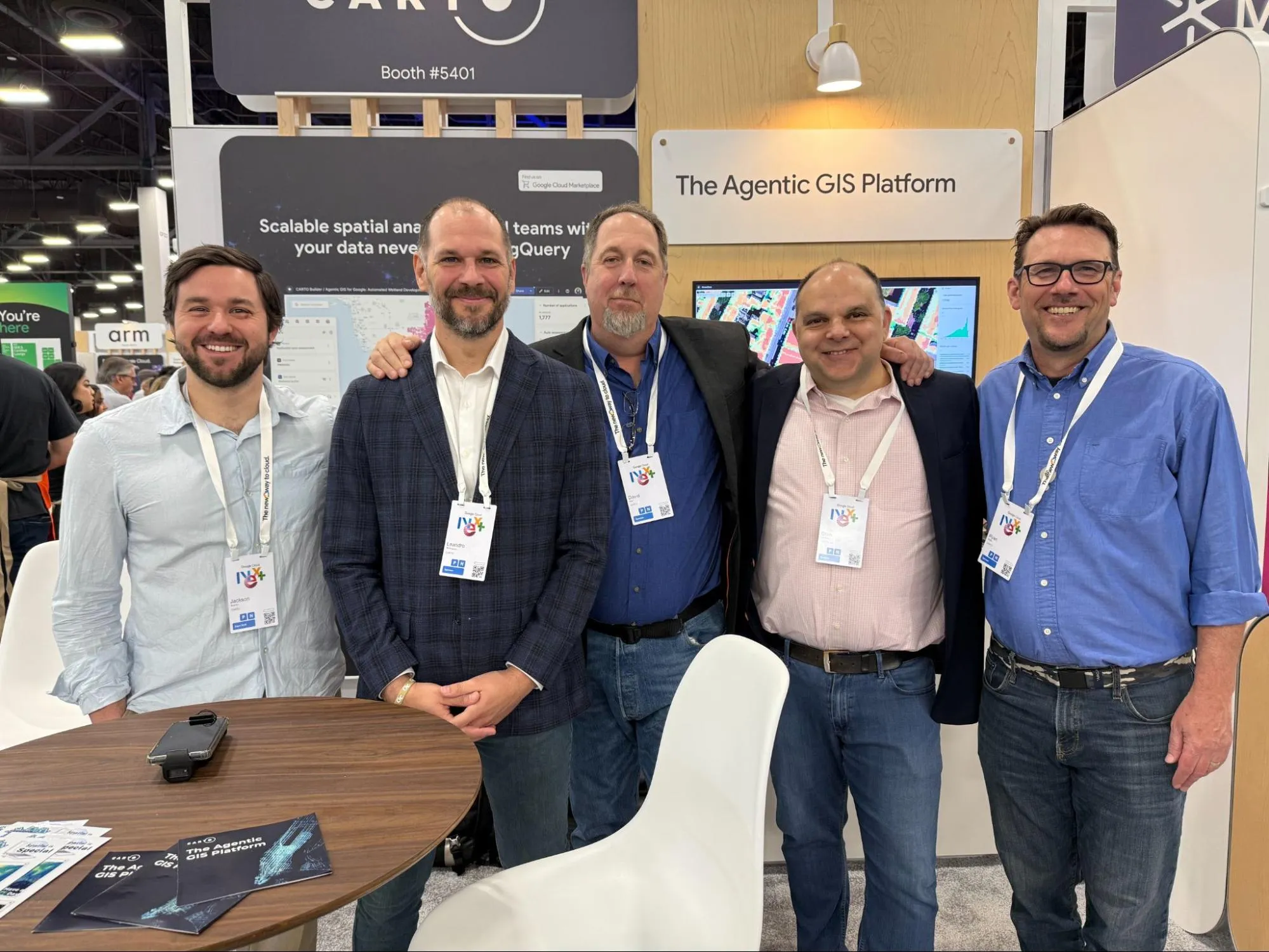
The CARTO team at the Expo at Google NEXT '26
We were there for all of it: the sessions, the demos, the partner conversations. Here are the five geospatial AI takeaways we think every analytics and AI team on Google Cloud needs to know about.
Trend 1. The AI stack’s spatial layer just got an upgrade
The marquee platform announcement at Next ‘26 was the Gemini Enterprise Agent Platform: Google’s new comprehensive system for building, scaling, governing, and running AI agents inside enterprise environments. It is a big deal. But for us, the most exciting part was not the orchestration layer. It was what the agents are now grounded in.
During the keynote demo, Andi Gutmans spotlighted a supply chain agent using Google Earth AI and live satellite imagery to identify a wildfire and an interstate closure, then joined that spatial context with internal supply chain data in BigQuery to quantify the business risk in real time. Roads Management Insights and Street View Insights were the geospatial products doing the heavy lifting behind that demo.
That is an example of today’s vision for Agentic GIS. Not as a concept, but as a working system. The agent does not just answer a question; it reasons about where something is happening, what the physical context means, and what that implies for the decision at hand.
If you are leading an analytics or AI team, the implications are big. The data is already there (inventory, demand, risk, operations), centralized in BigQuery. What has been missing is a spatial layer that connects all your data to the real world and puts it in the hands of AI agents.
That missing piece has finally arrived in two options:
- Ready-to-go agents in the Gemini Enterprise Agent Marketplace
- The tools and data for analytics teams to build their own
Click here to learn more (image source: Google Cloud)
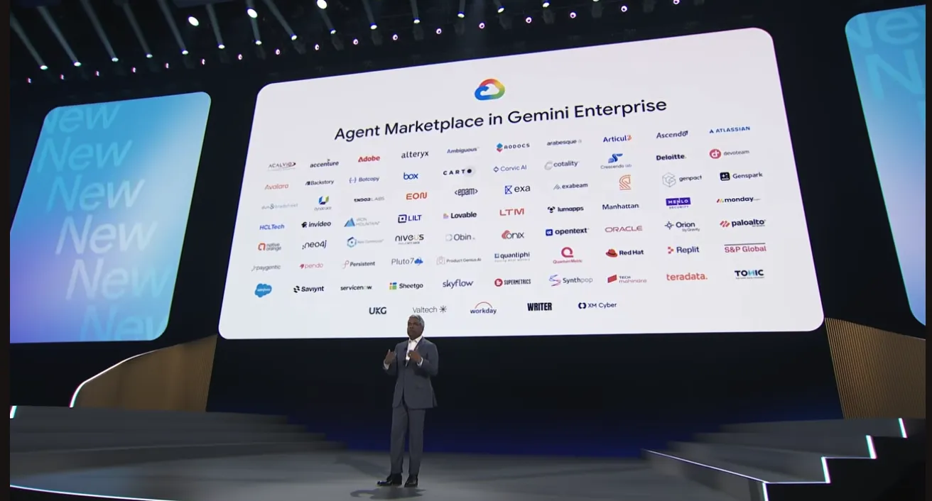
Trend 2. Geospatial is now at the center of enterprise AI
Google launched its new Gemini Enterprise Agent Marketplace partner program, and CARTO is the only Agentic GIS provider included. Let’s repeat this for the back of the room. CARTO is the only Agentic GIS provider included!
We are genuinely proud of this. It is a reflection of a fundamental architectural difference between how CARTO is built and how legacy GIS desktop platforms operate. Desktop-first GIS tools were not built for cloud-native, agent-orchestrated workflows that Google is now putting at the center of its enterprise AI strategy.
That is why Google picked us, and is why an Analytics Director evaluating AI agent investments in 2026 should be asking every GIS vendor the same question:
“Can your platform feed spatial data at scale into an agent that operates inside our cloud, without creating a new data silo or a new governance problem?”
The System Integrators building on this stack at NEXT were equally encouraging. Deloitte, Woolpert, and Accenture all had a strong presence at the event and are using CARTO inside Google Cloud. Next ‘26 was also a chance to connect with some of our Exclusive Partners who are deeply invested in the Google Ecosystem, and discuss how we bring Location Intelligence to Google customers at scale, including in Brazil with Geoambiente and ArkeUp GIS in France.
Click here to learn more (image source: Google Cloud)
Trend 3. The location data gap in the data warehouse is closing
If you have ever spent a week sourcing, cleaning, and ingesting location data before you could even start your analysis, this section is for you.
Google Next ‘26 brought a genuinely exciting set of new geospatial data products from the Google Maps Platform team, and the thing that makes them different from previous data offerings is where they live. These products live directly in BigQuery, so you can join them to your proprietary data in spatial SQL without an ingestion pipeline, format conversion, or a data engineering sprint before the actual work begins.
Here are three announcements we think will make a real difference for analytics teams:
Population Dynamics Insights is one of the most interesting new datasets we have seen in a while. It takes aggregated signals from Google Search trends, Maps activity, mobility patterns, and environmental conditions and compresses them into analysis-ready location embeddings, essentially a rich spatial fingerprint for any point on Earth. In benchmarking across 27 socioeconomic and health tasks, it reduced forecasting error rates by up to 20% compared to traditional demographics data. For teams building site selection models, demand forecasting workflows, or geographic risk scores, that accuracy lift comes with zero feature engineering required. You join the table and start modeling. Check out how you can leverage this with CARTO and see this in action.
Roads Management Insights brings something that logistics and transportation teams have wanted for a long time: ground-truth, near-real-time insights on what is actually happening on the road network. Road disruptions, vehicle counts, hard braking events, lane conditions, all sourced from anonymized connected vehicle data and available directly in BigQuery. It is expanding beyond the public sector into mid-mile logistics and roadside assistance this year. For operations teams, this replaces expensive third-party data contracts and custom sensor infrastructure with a single, warehouse-native feed.
Places Insights is expanding to 36 more countries, with brand-level competitive intelligence launching in the UK, Canada, and Australia. The addition of historical data going back to January 2024 is particularly compelling: it turns static point-of-interest data into a time series, letting retail, real estate, and financial services teams track how commercial landscapes evolve month by month before committing capital to a market entry or site decision. See how this is leveraged in CARTO’s Site Selection Agent on the Gemini Enterprise Agent Marketplace.
All of these feed directly into CARTO Workflows and AI Agent pipelines. The analysis starts where your data already lives. CARTO makes these data products accessible to every team, not just GIS specialists or data analysts. Reach out to your CARTO team to explore what is possible for your use case.
Trend 4. AI understands the physical world from satellites to street level
One of the most exciting frontiers opened up at Next ‘26 was the Imagery Insights suite. For anyone who has spent time trying to extract structured information from satellite or street-level imagery at scale, the progress here is significant.
Earth AI: The foundation for all of this is Google Earth AI, Google Research’s effort to build foundation models that understand the physical world from above and at ground level. These models are now being made available to enterprise teams through BigQuery and Gemini Enterprise Agent Platform, meaning the same technology Google uses to understand the planet is now something your analysts can run against their own data. CARTO is already building on this. Through our collaboration with Google Research’s Geospatial Foundation Models program, we have integrated AlphaEarth Foundations (Google DeepMind’s 10-meter resolution satellite embeddings) directly into CARTO Workflows. The goal is to take the spatial reasoning and pattern detection capabilities that today require specialist ML expertise, and make them available to any analyst through a low-code workflow component.
Aerial and satellite models: Analysts can search across the Earth’s surface using plain text prompts (for example, “find large HVAC cooling towers”) and the model identifies matching objects across entire geographies. You can also provide a reference image and ask the model to find similar assets globally, opening up workflows for infrastructure operators, insurers, and telecom network planners that previously required specialist ML teams to build from scratch.
Street View Insights: Now generally available and drawing on Google Street View’s repository of over 280 billion images, Street View Insights does something equally compelling at ground level. Teams can programmatically evaluate entire streetscapes to identify, locate, and condition-assess infrastructure assets: utility poles, lane markings, traffic signals, overhead lines. The results feed directly into BigQuery and Gemini Enterprise Agent Platform workflows, shifting asset management from reactive field inspection cycles to continuous automated monitoring. For a transportation agency or a utility operator, that is a genuine operational change.
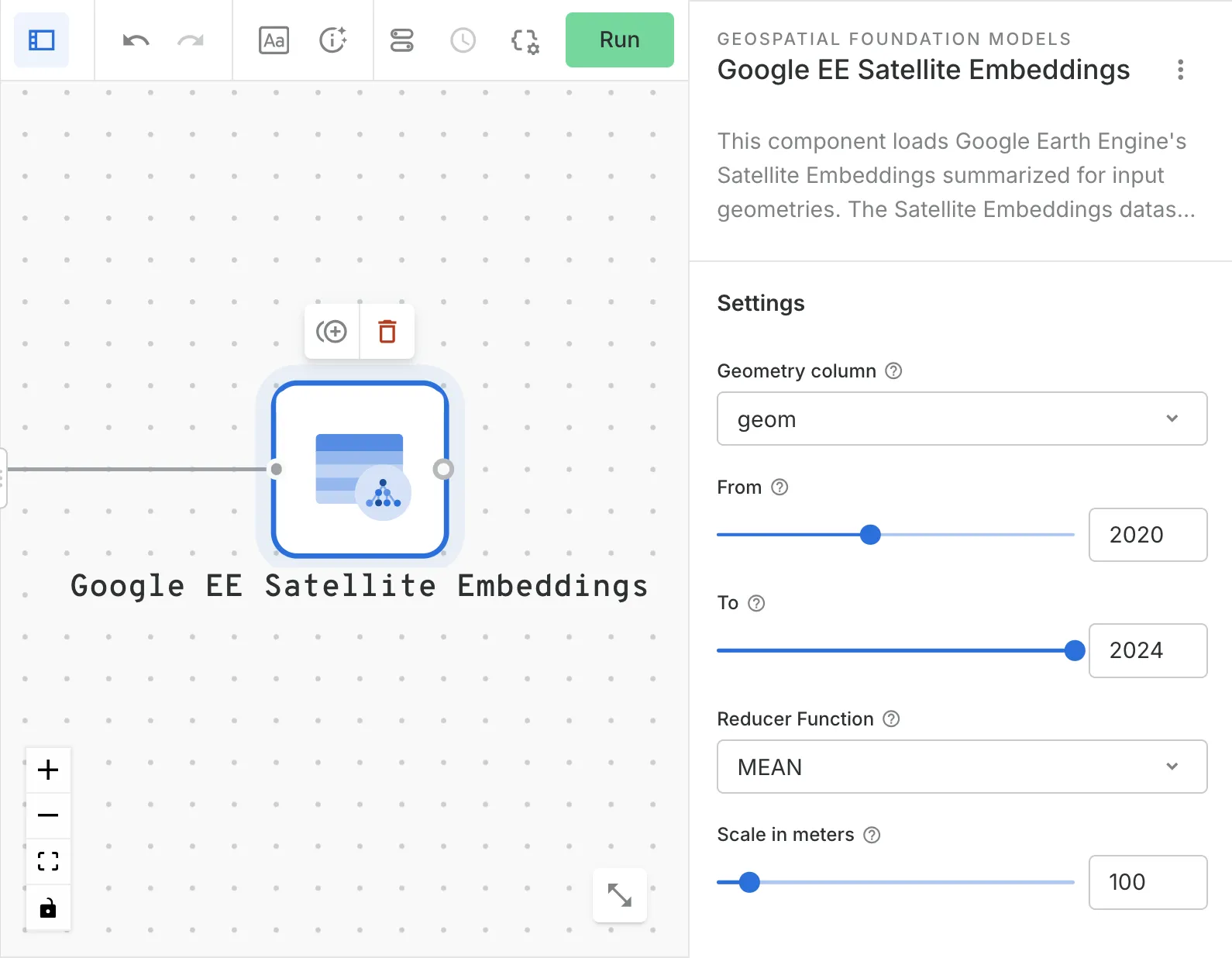
AlphaEarth Foundations in CARTO Workflows
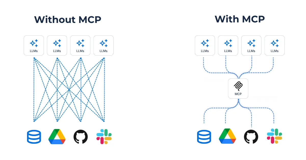
Trend 5. MCP changes how AI agents connect to spatial data
One of the more quietly significant announcements at Next ‘26 was the general availability of Maps Grounding Lite, a lightweight integration that lets any AI agent access Google Maps data through the Model Context Protocol (MCP). For AI teams building agents across different LLMs and frameworks, removing the need for custom connectors to get verified, live spatial data into an agent is a meaningful step forward.
Multiple breakout sessions at Next demonstrated it in action:
- The "Agent development and AgentOps with BigQuery, ADK, and MCP" session showed agents accessing BigQuery for analysis and Google Maps for geospatial insights inside a single workflow.
- The "Google MCP Services" session walked through connecting AI agents to Google Cloud infrastructure, Maps included, in minutes, with no custom integration code.
That is exactly what CARTO’s MCP Tools for AI Agents are designed for. Your whole team, from geospatial analysts to data scientists and analysts, can build spatial agents that understand location context, run geospatial workflows, and return map-based answers to business questions inside agentic platforms like Claude, ChatGPT, or Gemini Enterprise. All of it working inside your existing BigQuery environment, with the governance framework your team already trusts.
This is the architecture the Gemini Enterprise Agent Platform is designed around. It is also, frankly, the architecture that desktop-first GIS tools and their API-layer successors were never built to support. The gap between where enterprise AI is heading and where legacy spatial tools can follow is widening rapidly.
What this means for your team
Google Cloud Next always gives us a clear signal of where things are heading. This year, that signal was louder than ever for spatial data. The AI stack is converging on cloud-native, warehouse-first, agent-orchestrated workflows, and Location Intelligence is right at the center of it. Not as a specialist concern you hand off and wait on, but as a first-class capability available to every analyst, every agent, and every team that needs to understand where something is happening.
The organizations that move fastest will be the ones that stop treating location as a separate workstream. And the good news is that CARTO runs natively inside BigQuery, integrates with Gemini Enterprise Agent Platform and Google Studio, and inherits the governance and models your team already trusts. We are proud to be the only Agentic GIS partner in the Gemini Enterprise Agent Marketplace program, and honestly, it feels like the natural result of years of building in exactly this direction.
We would love to show you the impact these announcements can have on your AI and geospatial strategy. Request a demo and let’s dig in!