Mapping Geoawesomeness' Top 100 Companies and Startups


Founded in 2011 as a blog focused on highlighting the latest geospatial technologies Geoawesomeness has become a powerful resource for those looking to keep their thumb on the pulse of the Geospatial around the world. They've grown to be a platform for all things 'Location ' from news and trends to events and interviews with industry leaders.
Back in 2016 Geoawesomeness released their list of The Top 100 Geospatial Companies and Startups and now three years later they have decided that it's time for an update: Check out the 2019 Top 100 Geospatial Companies & Startups List!
Companies that made the list were selected by a panel of 16 experts including CARTO's own Javier De La Torre. Meet all of the panelists here.

The list is diverse featuring companies from Singapore to Spain (yours truly) to San Francisco and ranging in scale from tens of thousands of employees to fewer than five. This list dovetails nicely with recent Geoawesomeness initiatives like The Next Geo their vehicle to highlight entrepreneurship in the industry and an early step towards building out a community of innovators industry professionals and investors.
Building the Map: Airship and CARTO VL
To full visualize the diverse international nature of the list the team at CARTO worked to map and visualize every companies and startup in the Top 100.
To provide full context for each company our team included the following details:
- Company name
- A link to each company's Twitter
- Location
- Year founded
- Each company's summary from the list
The details section and the map's legend and company count widget are built with the help of Airship CARTO's design library for building Location Intelligence applications along with Vue.js.
Additionally the map is built and optimized for interactivity using CARTO VL our Javascript library for vector rendering. This next-generation library enables designers and developers to have more flexibility and control when styling maps.
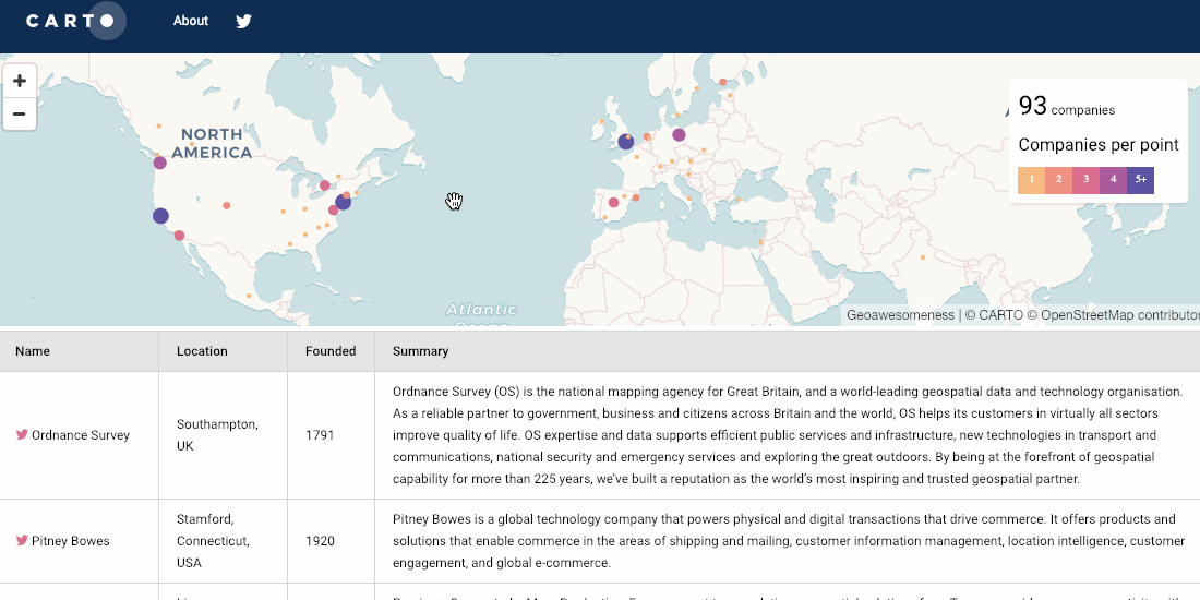
The map is able to seamlessly filter companies based on the map view. zooming in on your country of choice will showcase the list members in the detail view and automatically adjust the company count. Additionally hovering over a company in the detail section will highlight that company on the map for easy location.
Interested in learning more about CARTO.VL? Check out our recorded webinar!