

Map of the Month: World Refugee Day


Whether due to natural disaster climate change violent conflict persecution or human rights violations the displacement of people from their homes is reaching record highs. According to the UNHCR 65.6 Million people were displaced from their homes in the last year. If the displaced population were a country it would be the 22nd most populous in the world falling between Great Britain and France. Of the displaced population 22.5 Million are refugees displaced not only from their homes but from their countries as well.
The refugee crisis is a global problem as we highlighted in our 12 Maps That Tell The Story Of 2017 feature and global problems require powerful solutions. Solutions to the challenges faced by refugees displaced persons and the governments and organizations working to assist them are rooted in location data.
In recognition of World Refugee Day (June 20th) this month's Map of the Month post features several projects that are part of the wider work to help the world's refugees by:
- Monitoring the Global Refugee Crisis
- Providing Logistical Insights for Refugee Services and Support
- Telling the Stories of Refugees
Monitoring the Global Refugee Crisis
Monitoring the movement of refugees and displaced persons around the globe is invaluable work providing greater context around the impact of global crises and displacing events. By monitoring and mapping this movement organizations can provide insights to inform policy decisions raise awareness act as a resource for risk assessment and power real-time response for refugees.
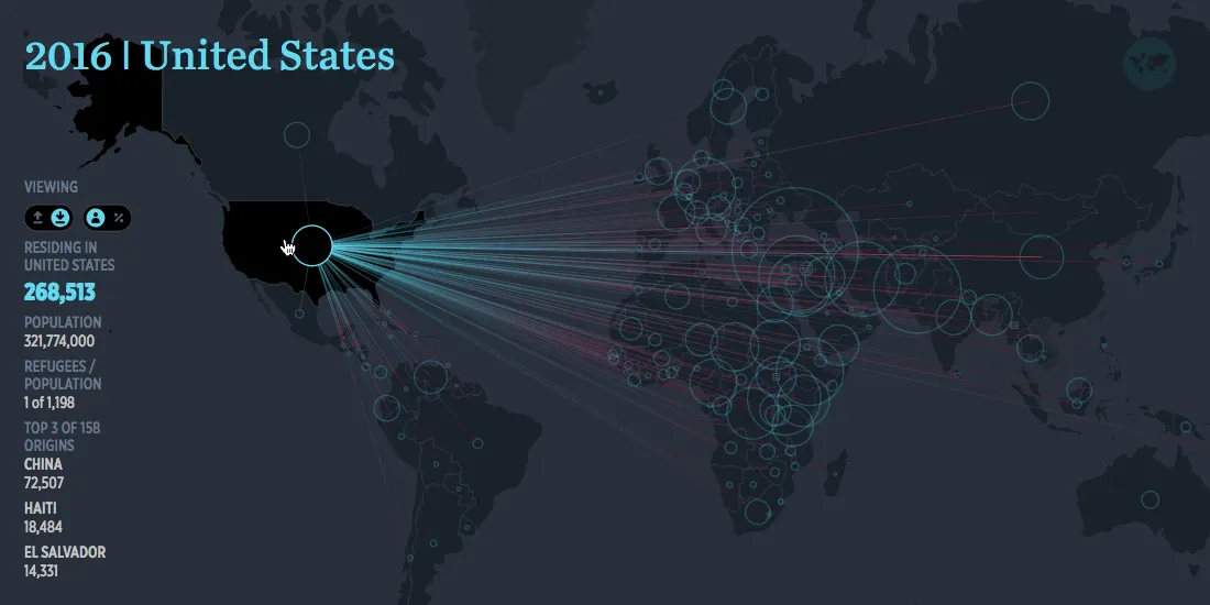
The Refugee Project
The Refugee Project maps out 42 years of refugee movement and is a reference for understanding not just the past but also the future of the global refugee crisis. The timescale component provides much needed context as major global events are identified and detailed as the map portrays over four decades of refugee movement.
The Internal Displacement Monitoring Centre: Updates and Global Map
The IDMC was established in 1998 and since then has provided global data on displacement and the events that cause it. In collecting and analyzing this data they are able to track patterns and gain a deeper understanding of the causes of internal displacement and provide advice that supports local national and global policy implementation.
Their Global Map as seen below provides a snapshot of displacement in the last year with icons depicting the number of displaced persons in each country and linking to country-level reports that provide deeper insight into the specific cause of displacement in that country.
Their Displacement Updates Map takes an active monitoring role providing an up-to-date view of displacement events occuring in the last 30 days and categorizing those events as either disasters conflicts & violence or development.
Logistical Insights for Refugee Services and Support
Whether monitoring conditions in refugee camps providing legal assistance to asylum seekers or providing a hub for refugee response and support many organizations are mapping location data to maximize their impact.
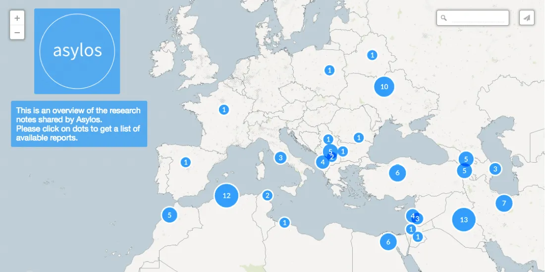
Asylos Research Notes
Asylos is a European volunteer organization that is committed to working as a repository of information and research for asylum-seekers around the globe. They have created a map with links to research notes to help lawyers in assisting global refugees fleeing dangerous circumstances.
IRIN & The Rohingya Risk Analysis Map
IRIN News is an outlet dedicated to reporting on emergencies around the globe. As part of their reporting on the Rohingya crisis in Myanmar where nearly 700 000 Rohingya refugees fled extreme violence and religious persecution to Bangladesh in 2017 alone they mapped out the conditions of the Kutupalong-Balukhali refugee camp.
The map overlays the camp layout with available health facilities as well as layers showing flood and landslide risk. Over 100 000 people live in the at risk areas. Hopefully by mapping these dangers the international community will become more aware and better positioned to mobilize resources to alleviate the tremendous risk that these people face.
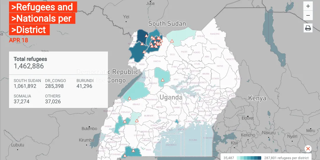
UNHCR's Uganda Refugee Response Portal
The United Nations High Commission on Refugees' Uganda Response Portal is designed to be a resource for local authorities and aid groups working on country-level coordination to assist the 1.5 million refugees currently in Uganda. Many of these refugees are located in northern Uganda along the border with crisis-torn South Sudan.
The portal provides information on policy events and coordination efforts alongside a map showing population density of refugees in the country and active refugee settlements. Through greater coordination aid groups can maximize their efficiency as they work to help the country's refugee population.
Telling the Stories of Refugees
By documenting displacement and migration and telling the stories of refugees organizations can shine a light on the challenges risks and dangers that refugees face around the globe. In addition to providing context to lawmakers working to bolster refugee protections these stories humanize refugee populations who are often otherwise met with resentment.
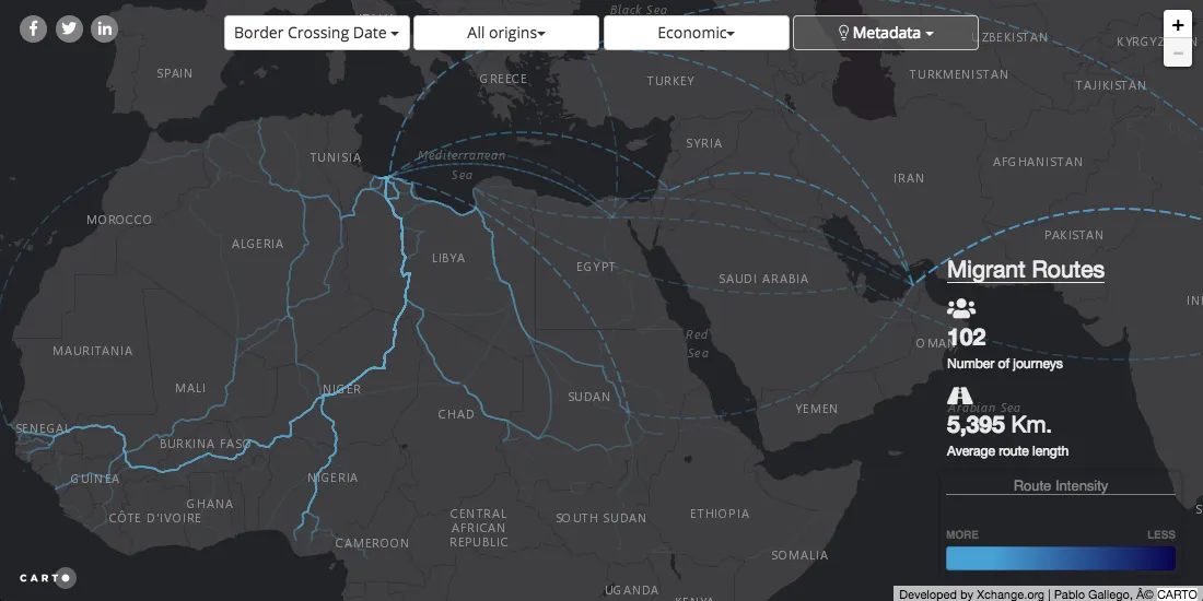
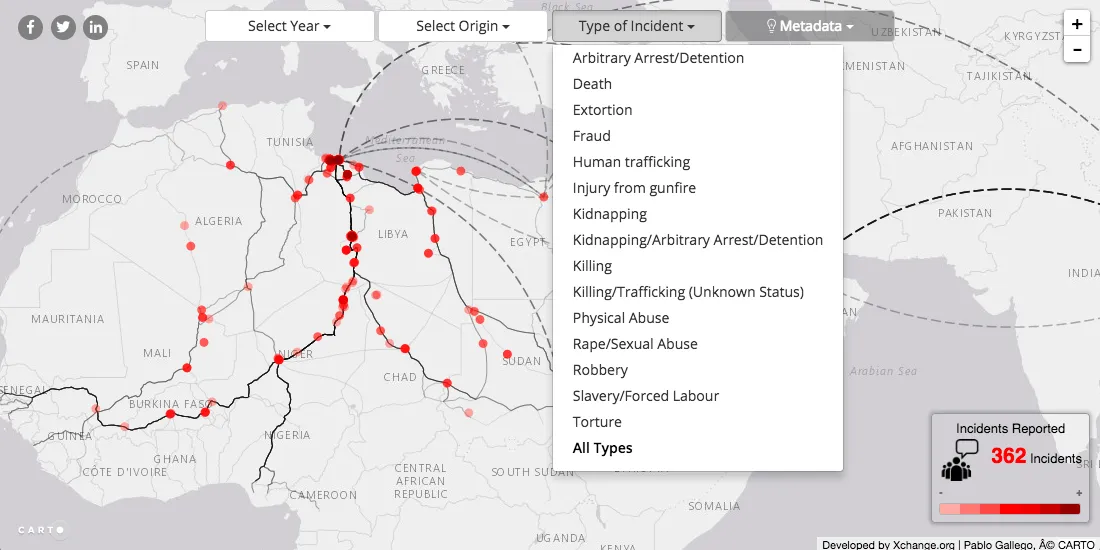
XChange.org Routes Incidents and Reports
XChange.org's stated mission is to "investigate and document human movement" and to "cast a spotlight on the information gaps found along the main migratory routes for the benefit of all." The approach these goals with a focus on the migrants themselves.
Through visualization analysis and in depth reports Xchange tells the stories of thousands of refugees migrants and displaced peoples around the world. Their recent Central Mediterranean Survey maps routes and incidents of these journeys allowing users to filter by country of origin "push factor" and "border crossing date"
Their Incidents Map below shows just how vulnerable refugees are and how they are susceptible to dangers such as arbitrary arrest and detention human trafficking and slavery forced labor sexual assault and rape.
Missing Migrants
In what is possibly the most stark depiction of the dangers faced by refugees and displaced persons the International Organization for Migration's Missing Migrants project maps out migrant deaths as identified along common migration routes. Whether they are fleeing gang violence in Central America religious persecution in Southeast Asia or are otherwise displaced by circumstances outside of their control refugees and migrants risk their lives in search of a better situation for themselves and their families.
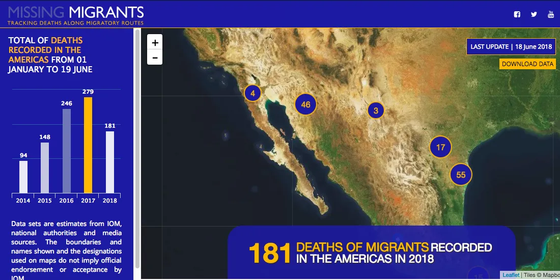
Many of the people who die on these routes go unidentified.
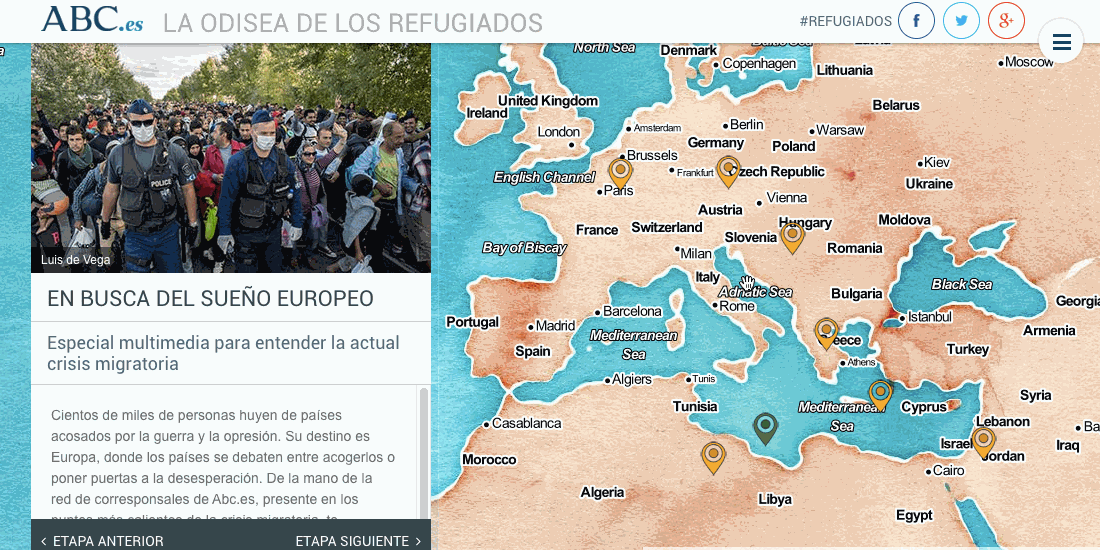
ABC.es The Odyssey of Refugees
To provide their readers with greater understanding of the impact of refugees on Europe and the stories of those refugees Spanish news organization ABC put together their Odisea De Los Refugiados or Odyssey of Refugees project. The project maps out the refugee story and amplifies it with images and video.
Learn more this World Refugee Day
Projects like those listed above are doing their part to tell refugee stories provide governments and non-governmental organizations with the information they need to enact new policies and provide services to vulnerable refugee communities.
In the face of powerful forces that work tirelessly to dehumanize refugees take the opportunity this World Refugee Day to be reminded of their humanity and recognize that few things are more painful than being forced from your home. Learn more about the global refugee crisis at UNHCR.org.
Learn more about how Location Intelligence is being used to address global challenges. Check out our Webinar!


