Migrate from Esri to CARTO with your AI Agent



Most enterprise GIS teams are not held back by their skills. They are held back by where their spatial work is forced to live: in a separate locked-in system that keeps its own copy of the data, instead of running on the cloud data warehouse the rest of the business already uses. And the cost of staying there keeps climbing.
Many teams already know they have outgrown that model. Their business data sits in BigQuery, Snowflake, Databricks, Redshift, or Oracle, yet their spatial work runs in a separate silo. Because access to the GIS systems is gated to a few named users, every spatial question funnels through the same small team. And, as a consequence, skilled GIS professionals spend their days fielding repetitive map requests instead of the higher-value analysis they were hired to do.
So why do teams struggle to move on? Because migrating off Esri feels risky. Years of data, maps, and apps live in ArcGIS, and moving them looks like a project with no clear end. This post is about why that fear is outdated, and how CARTO provides you with AI workflows and tools running in your own environment to carry out the migration, with AI Agents working alongside your experts who stay in control the whole way. The result is a migration with far less disruption and risk than the all-at-once cutover teams fear.
Why teams outgrow ArcGIS
This is not about vendor preference. The friction is architectural. With ArcGIS, your data usually gets copied into Esri-managed storage and formats, which duplicates your source of truth and drifts out of date the moment the copy is made. And because that copy lives apart from the data warehouse where the rest of the business and its AI already work, your most valuable spatial data stays siloed instead of powering the company's wider data and AI strategy. It is also a matter of geospatial sovereignty: data held in one vendor's proprietary storage and formats is data you no longer fully control. We cover this trade-off in detail in our guide to choosing the best spatial analytics platform.
The cost compounds the problem, and Esri's recent licensing changes have made it sharper. As it moves customers from a concurrent-use model to named-user licensing, the economics shift against exactly the organizations that share spatial tools across a broad workforce:
- Bills are climbing: organizations converting to named users report costs rising two to three times, because every user now needs an individual seat whether they log in daily or a few times a quarter.
- Shared flexibility is gone: the old concurrent-use model let a pool of licenses float to whoever needed one, when they needed it. Named-user licensing requires a dedicated seat for every person, casual users included.
- Extensions are tied to people, not projects: Network Analyst, Spatial Analyst, and 3D Analyst used to be drawn from that shared pool on demand. Now each is allocated to specific users, so someone who needs one for a single project can no longer borrow it temporarily.
- Administration is heavier: what the license pool handled automatically now takes hands-on intervention for every assignment, switch, or extension allocation.
- Maintenance keeps rising: independent of the model change, annual maintenance prices have continued to increase.
The effect is the same one that traps GIS teams in a service-desk role: when every spatial question has to pass through a small group of licensed seats, the business waits days for answers it needs now. The constraint is not the team's talent. It is access and cost. We make the full case for moving past seat-based licensing in The per-seat trap, and lay out a side-by-side view in our Esri alternative for enterprise teams.
Faced with these costs, many teams' first instinct is to fall back to open source like QGIS. But that just moves the problem: a desktop tool keeps your spatial work siloed on individual workstations, off the cloud, and outside the governance your enterprise depends on. You save on licenses without actually modernizing.
You do not have to make that trade. CARTO is a cloud-native, agentic alternative that runs directly on the data in your warehouse, with enterprise-grade governance and security, and pricing that scales with use instead of seats.
Migration does not have to be a big-bang cutover
The reason migrations stall usually is not the will to move. It is not knowing where to start, how much effort it will take, whether your specific maps and workflows will move cleanly, and who is going to do the manual rebuilding. That is exactly what changes here, and none of it requires an all-at-once cutover.
ArcGIS keeps running while you migrate. Most teams start with one use case, run both platforms in parallel, and retire ArcGIS licenses as CARTO proves results. Your ArcPy scripts and ModelBuilder workflows keep working in ArcGIS the whole time.
Think of it as a division of labor rather than a rip and replace. CARTO takes on cloud-scale analysis and visualization on the data already in your warehouse, while ArcGIS keeps handling the specialized GIS work your team still relies on, such as heavy imagery or field data collection. You move the work that benefits most from the cloud first, and you move the rest only when it makes sense. Some teams do move everything at once to capture the savings sooner. Either pace works, and you choose it, not the tool.
Governance is the other common worry, and here CARTO removes the risk. CARTO runs spatial analysis directly inside your cloud data warehouse, so your data never has to leave your governed environment. Your existing data access controls apply without modification. The same holds for AI: CARTO works with the models and AI providers your organization already approves, and agents act on your data inside that same governed environment, with every action logged and attributable. You can see the full step-by-step path on our Migrate from Esri to CARTO page.
A guided migration, run by an AI agent
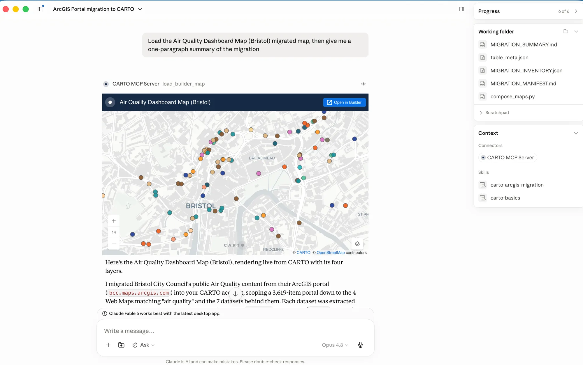
This is where the migration stops being a manual project. As part of CARTO for Agents, we published a set of open CARTO Agent Skills that teach AI Agents how to operate CARTO via our CLI and MCP Server. One of them, carto-arcgis-migration, handles the move from ArcGIS Enterprise or ArcGIS Online to CARTO end to end.
You point it at your ArcGIS Enterprise or ArcGIS Online endpoint, and it works in three phases:
- Discover: the agent inventories everything in your Portal, including feature layers, tables, web maps, dashboards, and apps, classifies it, and writes a migration plan for you to review. Nothing moves until you approve it.
- Migrate data: hosted feature layers and tables become tables in your connected data warehouse, with no copies left to maintain.
- Migrate maps: web maps and simpler apps become CARTO Builder maps, tagged From ArcGIS and kept private by default, so you decide what goes live.
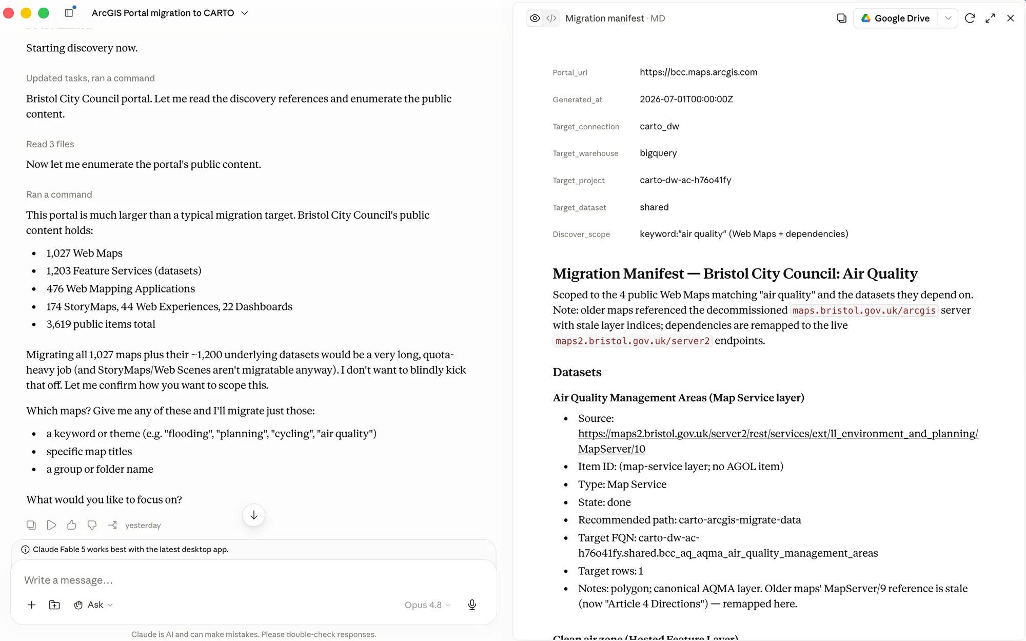
The process is built to run at enterprise scale. It works in batches, and it is safe to re-run: run it again and it skips what already moved and retries only what failed. A large migration can run in stages over days or weeks without ever losing track of what is done.
💡 You stay in control the whole way. The agent proposes a plan, you review it before anything moves, and your data never leaves your warehouse.
Your expertise comes with you
Bringing your spatial work into the cloud does not mean throwing away what your team knows. The concepts you have spent years mastering carry straight over. They just run on the warehouse, where the whole business can build on them, instead of staying trapped on a single workstation.
| In ArcGIS | In CARTO |
|---|---|
| ModelBuilder workflow | CARTO Workflows, with models and procedures running in your data warehouse |
| ArcPy script | Python or SQL, running natively in the data warehouse |
| Geoprocessing and spatial analysis tools | Spatial SQL and the CARTO Analytics Toolbox, with H3 and Quadbin spatial indexes for analytics at scale |
| Local geodatabase and feature classes | Tables in your cloud data warehouse or in Apache Iceberg catalogs based on open formats such as GeoParquet and Raquet |
| Published web map or app | CARTO Builder map or a custom app based on CARTO and deck.gl |
CARTO is SQL-first and built on open standards, so your work stays in portable formats rather than a new proprietary silo. Because everything runs as SQL where your data already lives, the rest of your data team can build on it without a GIS license, and the analyses your team designs become shared assets instead of one-off files.
What moves, and what stays in Esri
Being clear about scope matters more than overselling. Here is what the migration covers today, and what it does not.
Moves cleanly: hosted feature layers and tables, web maps, and simpler apps such as Dashboards, Web Experiences, and Web Mapping Applications.
Stays in Esri for now: complex imagery and LiDAR analysis, offline field data collection, and BIM workflows are areas where Esri continues to lead. If those are central to your work, CARTO will tell you during the readiness assessment, rather than after you commit.
From a service desk to a strategic function
The real prize is not a cheaper license. It is what the GIS team gets to do once spatial answers are available across the business instead of stuck in a request queue.
- Analysis where your data already lives: CARTO runs as SQL inside your warehouse, so there are no copies to maintain and no ETL pipelines to keep in sync.
- Your expertise, encoded and scaled: the workflows your team builds become reusable services that business users and AI agents can call, so your knowledge reaches the whole organization instead of one ticket at a time.
- Spatial analysis everyone can reach: business users ask questions in natural language and get answers directly, which frees your specialists for the proactive, high-value work only they can do.
- Pricing that scales with use, not seats: consumption-based pricing means access is not rationed by license count, so adding a viewer costs you almost nothing.
- Ready for Agentic GIS: an AI agent in your own environment runs the migration, and once you are on CARTO, the platform's built-in AI Agents run on your spatial data too, which is where enterprise analytics is heading.
This is the shift that turns a GIS team from a support function into a strategic one. As we saw at Google Cloud Next '26, the gap between cloud-native, agent-ready platforms and legacy, seat-bound GIS is widening fast, and the teams that modernize now are the ones setting the agenda for how their organizations use location. If you are still weighing options, our guide to how to choose a GIS platform lays out eight features to compare before you commit.
Ready to migrate?
The hardest part of leaving Esri is knowing where to start, and whether your specific workflows will move cleanly. That is exactly what the migration readiness assessment is for.
It takes about two minutes to answer, and gives you a personalized readiness signal: the likely effort, an indicative timeline, and the right CARTO entry point for your team. The migration itself then moves at the pace and scope you choose. If something you rely on is better kept in Esri, it will tell you that too.
Take the Esri migration readiness assessment and get your personalized plan.
Need help migrating? CARTO has a team of Forward Deployed Engineers that can assist your teams or manage the migration on your behalf.
Frequently Asked Questions
Can I migrate from ArcGIS to CARTO without a big-bang cutover?
Yes. ArcGIS keeps running while you migrate. Most teams start with one use case, run both platforms in parallel, and retire ArcGIS licenses as CARTO proves results. A large migration can run in stages over days or weeks, and you choose the pace and scope.
What does the AI agent actually migrate?
The open carto-arcgis-migration Agent Skill works in three phases: it inventories everything in your ArcGIS Enterprise or ArcGIS Online portal and writes a migration plan for your review, migrates hosted feature layers and tables into your cloud data warehouse, and recreates web maps and simpler apps such as Dashboards, Web Experiences, and Web Mapping Applications as CARTO Builder maps. Nothing moves until you approve the plan.
What should stay in ArcGIS for now?
Complex imagery and LiDAR analysis, offline field data collection, and BIM workflows are areas where Esri continues to lead. CARTO’s migration readiness assessment flags these dependencies upfront, so you know what to keep in ArcGIS before you commit.
Does my data leave my environment during the migration?
No. CARTO runs spatial analysis directly inside your cloud data warehouse, and the migration agent runs in your own environment using the AI models and providers your organization already approves. Data moves from ArcGIS into your governed warehouse, your existing access controls apply without modification, and every agent action is logged and attributable.
What happens to my ArcPy scripts and ModelBuilder workflows?
They keep working in ArcGIS throughout the migration. Their equivalents in CARTO run in your data warehouse: ModelBuilder workflows become CARTO Workflows, and ArcPy scripts become Python or SQL running natively in the warehouse, where the rest of your data team can build on them without a GIS license.
How long does a migration from Esri to CARTO take?
It depends on the size of your portal and how much you choose to move. The migration runs in batches and is safe to re-run: it skips what already moved and retries only what failed, so it can run in stages over days or weeks. CARTO’s two-minute readiness assessment gives you an indicative timeline and the likely effort for your specific setup.