How to share geospatial insights without compromising data security



Your team just built a map that shows exactly where to expand next quarter. The analysis is solid, the data is sensitive, and six people across three departments need to see it. What happens next?
In most organizations, the answer involves downloading a dataset, emailing a static screenshot, or copying data into yet another tool. Each step creates a new security gap. Each copy of the data lives outside your governance framework. And when someone asks “who has access to this?”, nobody has a clear answer.
This is the core tension in geospatial analytics: the insights are only valuable if people can act on them, but sharing those insights often means losing control of the underlying data. For large enterprises, that tension is not just inconvenient. It is a governance risk.
The real cost of “just export it”
Spatial data carries more risk than a typical spreadsheet. A map of customer locations, delivery routes, or asset positions reveals operational patterns that competitors would love to see. Insurance claim density maps, network coverage models, and site selection analyses all contain proprietary intelligence baked into the geography itself.
Yet the default workflow in many organizations still looks like this: run the analysis in one tool, export the results, upload them to a visualization platform, share a link, and hope nobody forwards it to the wrong person. Every handoff is a potential leak.
The problem gets worse at scale. Large enterprises with hundreds of analysts and dozens of teams end up with data copies scattered across personal drives, BI tools, and third-party mapping platforms. IT teams lose visibility. Compliance officers lose sleep.
Why traditional GIS makes this harder
Legacy GIS platforms were built for a world where analysts worked on local machines with downloaded datasets. Sharing meant publishing a static map or granting access to an entire server. There was no middle ground between “fully public” and “locked in one person’s desktop.”
Modern teams need something different. A product manager in London needs to see the same coverage map as a network planner in Chicago, without either of them downloading the raw cell tower data. A partner agency needs to interact with campaign performance maps without seeing the underlying customer records.
The requirements are clear: share the insight, protect the data, control who sees what, and keep an audit trail.
How cloud-native architecture changes the equation
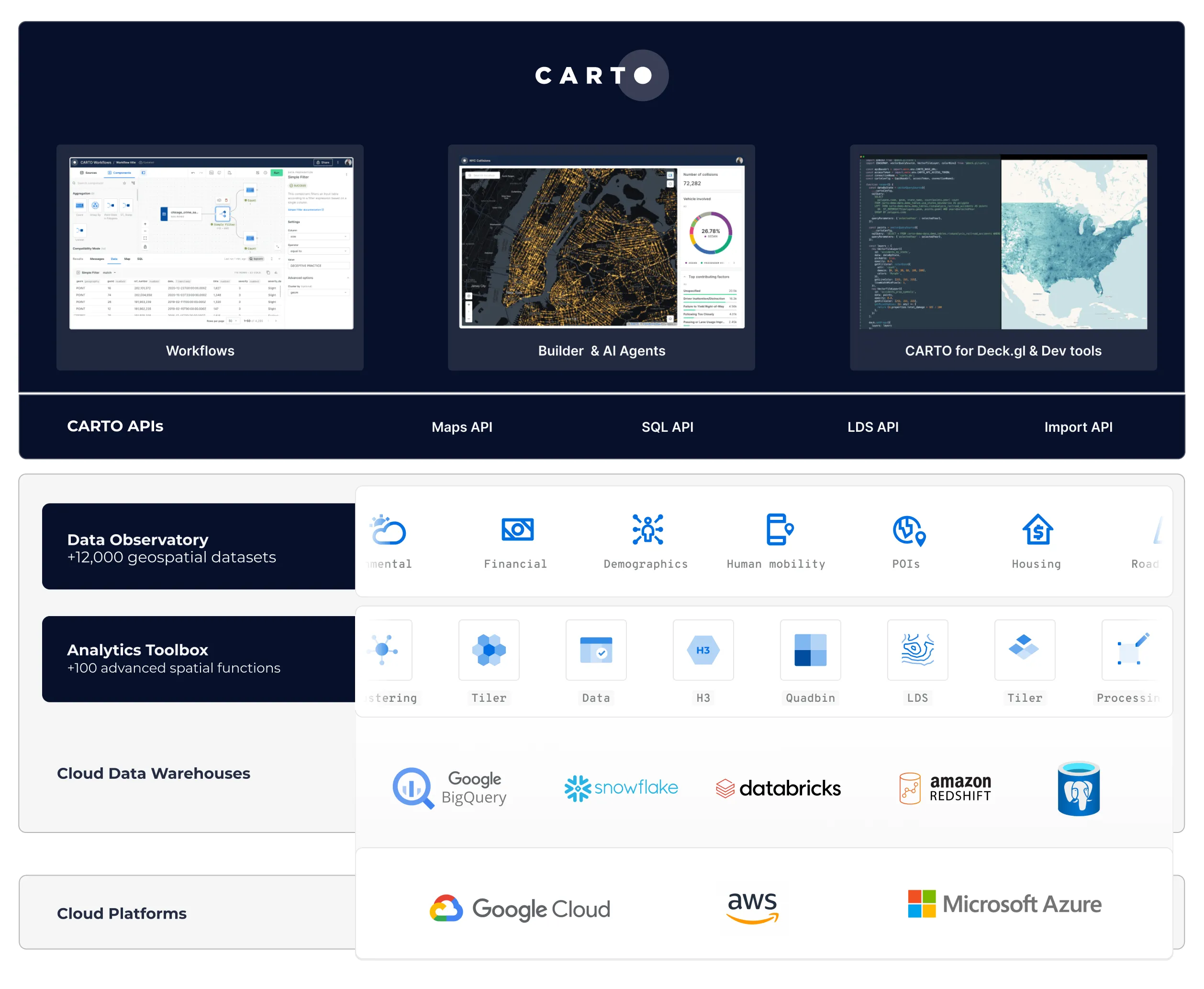
The shift to cloud-native spatial analytics changes the security model entirely. Instead of copying data out of your warehouse and into a mapping tool, analysis and visualization happen where the data already lives, inside your BigQuery, Snowflake, Databricks, Redshift, or Oracle environment.
This “zero-copy” approach has a simple but powerful consequence: your existing data governance rules apply automatically. The role-based access controls, encryption policies, and audit logs you’ve already configured in your data warehouse extend to every map and dashboard built on top of it. No separate permission system to manage. No data leaving your governed environment.
When a colleague opens a shared map, the platform queries your warehouse in real time, applying their specific access permissions. They see the visualization. They interact with filters and tooltips. But the raw data never leaves your infrastructure.
Granular sharing without the overhead
Controlling access at a granular level used to require custom development or awkward workarounds. Cloud-native platforms make this straightforward.
Team-level access lets you control which departments or groups can view specific maps and datasets. An underwriting team sees risk concentration maps. A sales team sees territory performance. Neither group has access to the other’s data.
External sharing through secure links allows partners and clients to interact with maps without needing a full platform account. The link delivers the visualization while the data stays in your warehouse.
Row-level security inherited from the data warehouse means you can share a single map with multiple audiences. Each viewer sees only the data their permissions allow. One map, many views, zero manual filtering.
Meeting compliance requirements head-on
Regulatory requirements like SOC 2, GDPR, and industry-specific mandates are not slowing down. If anything, boards and regulators are paying closer attention to where data moves and who touches it.
A cloud-native approach simplifies the compliance conversation. Your spatial analytics platform inherits the certifications of your data warehouse. Data residency requirements are met because data never moves. Audit trails are built into the warehouse’s native logging, not a separate system you have to maintain.
For organizations with strict data residency or air-gap requirements, self-hosted deployment options put the entire platform inside your own infrastructure. Same capabilities, complete control.
AI changes the stakes for geospatial data governance
The rise of AI in geospatial analysis adds a new layer of complexity to data security. When AI agents can query spatial data, generate analyses, and produce recommendations on behalf of users, the question of who controls the data becomes even more urgent.
Consider what happens when an organization connects an AI model to its geospatial data. If the platform sends that data to an external AI provider for processing, the organization loses control over where it goes, how it is stored, and whether it gets used to train future models. For industries like insurance, telecoms, and government, that is a non-starter.
Geospatial sovereignty requires a layered approach. At the data layer, open formats and warehouse-native storage keep data portable and under your control. At the compute layer, analysis runs where your security policies already apply. At the AI layer, the platform should let you choose and swap AI providers without locking you into a single vendor or sending data outside your trust boundary.

This is not a theoretical concern. As AI-assisted decision making becomes part of everyday spatial workflows (from zoning recommendations to network optimization), the legal and architectural foundations need to work together. Documentation, auditability, and human accountability are just as important as encryption and access controls.
A platform built for enterprise-grade security should support configurable AI providers, keep all processing within the customer’s governed environment, and maintain full audit trails for every AI-generated output. That way, teams can adopt AI for spatial analysis without opening new governance gaps.
What this looks like in practice
A large insurance company needs to share catastrophe risk models with regional teams across 12 offices. Instead of distributing spreadsheets and static PDFs every quarter, they build interactive maps that query their cloud data warehouse (BigQuery, Snowflake, Databricks, or Redshift) directly. Each regional manager sees only their territory. The actuarial team sees the full picture. The compliance team has a single audit log covering every access event.
No data was exported. No copies were created. No new security review was needed.
That is what it looks like when the platform respects your governance framework instead of working around it.
Start sharing insights, not data
If your team is still choosing between security and accessibility, the architecture is the problem, not the people. A cloud-native spatial analytics platform removes that tradeoff entirely.
Request a demo to see how CARTO keeps your data protected while making spatial insights accessible to every team that needs them.
Editor’s note: This post was originally published in 2014 and has been completely revamped and updated for accuracy and comprehensiveness.