PlacePulse: How we built our first geospatial foundation model


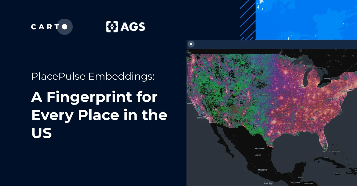
What makes two places similar, even when they are hundreds of miles apart? Often, it is a combination of characteristics: who lives and works there, the businesses around them, and the environment they share. PlacePulse, CARTO’s first geospatial foundation model, brings these characteristics together in a compact representation that can be reused to compare locations, identify patterns, and predict outcomes.
In our first announcement, we introduced PlacePulse Embeddings and showed how they open up new ways to work with spatial data. Since then, we’ve explored applications in sectors like retail expansion and EV charging infrastructure. Now, we’re sharing the research behind the model: how we built it, what its embeddings capture, and how we tested their usefulness across different tasks and regions.
Our new paper presents the model alongside a framework for evaluating geospatial embeddings, from the information they preserve to their performance on new prediction tasks. In this post, we take a closer look at the approach and some of the main findings.
How we built PlacePulse
PlacePulse turns rich, place-level context into compact embeddings. For each location, we start with 572 attributes describing the people who live and work there, the businesses operating nearby, commuting patterns, climate conditions, and exposure to natural hazards (from Applied Geographic Solutions 2025 national database). We then add neighborhood context before training, expanding each cell’s input to 2,288 features. This lets the model learn not only what is true of a place itself, but also how it relates to its surrounding area. The result is a 256-dimensional vector that captures the character and context of each location in a form that is easy to compare, cluster, and use in downstream models.
A masked autoencoder learns compressed representations without labels. During training, it masks 30% of the input attributes and reconstructs them from the remaining features, forcing the model to learn relationships among place attributes rather than simply copy the input. The result is a single embedding for each of the 1,055,537 H3 resolution 7 cells covering the United States.
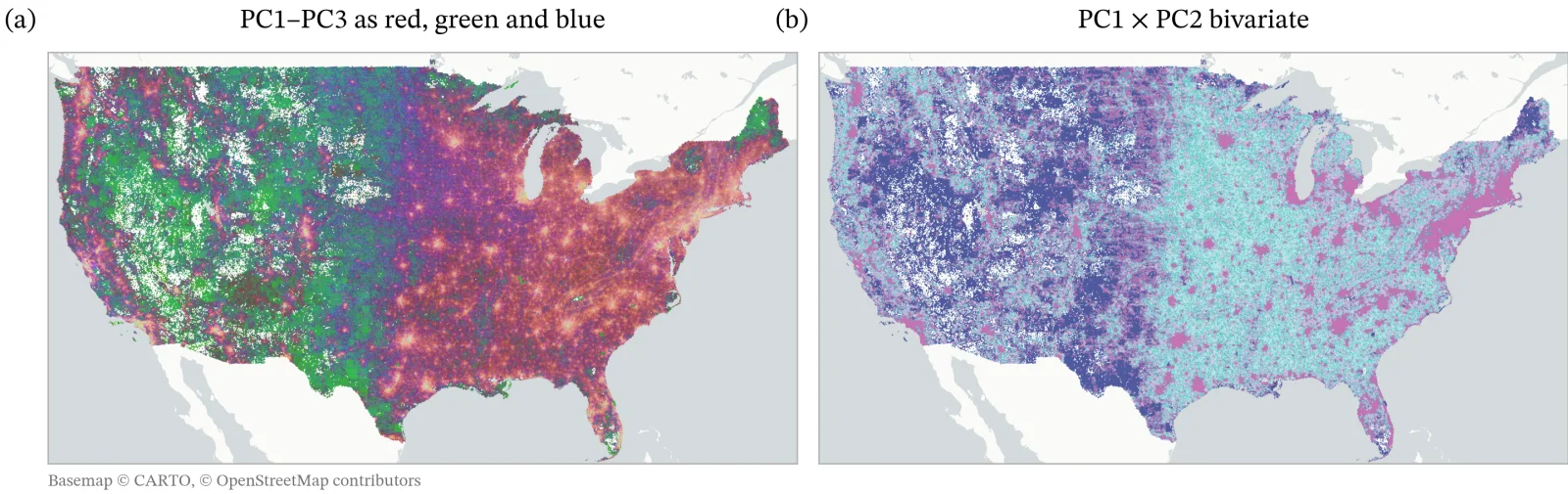
Visualizations of the presented embeddings colored by principal component analysis (PCA) of the 256-dimensional embeddings.
PlacePulse learns entirely from structural data. It captures the demographic, economic, and environmental characteristics of places, offering a different perspective from models built on imagery or behavioral signals such as visits and search activity. Our evaluation examines how much these structural attributes can tell us about a place and how useful that information is across different tasks.
A benchmark for geospatial foundation model embeddings
How do we assess a representation designed to support many different uses? Performance on a single task gives us only part of the answer. Our benchmark examines both what the embeddings capture and how useful they are when applied to new prediction tasks.
- Representation quality (intrinsic evaluation). We evaluate reconstruction fidelity, latent-space structure, effective dimensionality, and spatial organization to test whether the model has learned a compact, non-collapsed, geographically meaningful representation of place.
- Predictive transfer (extrinsic evaluation). Can the embeddings help predict outcomes they were not trained on? We evaluate the embeddings on 74 held-out prediction targets from 12 external sources, across four spatial supports, using a fixed estimator and state-blocked cross-validation. This makes the benchmark a test of geographic transfer, not just local interpolation.
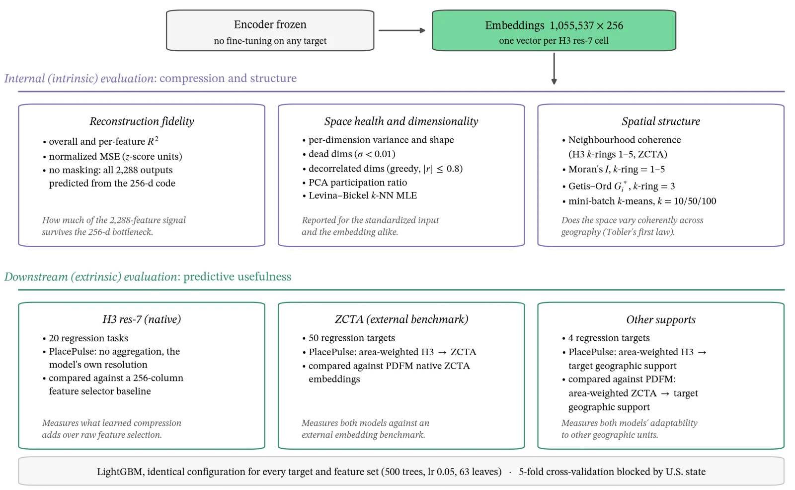
Evaluation benchmark for Geo-Foundation Model embeddings. We extrinsically compare our model with the state-of-the-art Population Dynamics Foundation Model (PDFM) using the described protocol.
Because the framework is independent of the model architecture and input data, it provides a common basis for comparing different geospatial embeddings.
Inside the PlacePulse representation
What does PlacePulse learn from structural data, and how far can that information take us? Three insights are especially important. First, a place can be compressed into just 256 numbers while retaining much of its predictive value. Second, geography appears in the embedding space even though the model is not directly trained to learn a map. Third, static structure and behavioral data capture different aspects of place, suggesting that they are complementary rather than interchangeable.
Insight 1: preserving information in 256 dimensions
How much information survives when 2,288 input features are compressed into 256 numbers? PlacePulse reconstructs its standardized inputs with a median R² of 0.887, indicating that the compact representation preserves much of the variation in the original data. Every input feature is reconstructed at least as well as a baseline that always predicts its mean.
The model also makes use of the embedding’s full width. A test that progressively removes highly correlated dimensions retains 251 of the 256, suggesting that few dimensions simply duplicate one another. Together, these results show that PlacePulse achieves substantial compression while retaining information across a broad set of place characteristics.
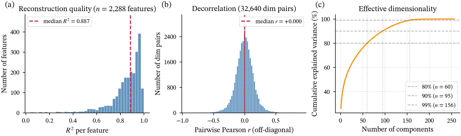
Intrinsic evaluation of PlacePulse Embeddings.
Insight 2: geography shows up on its own
The model is never given an explicit location. It sees no coordinates, distances, or boundaries; only place attributes and local context. Yet the embedding space becomes strongly geographic.
Spatial autocorrelation is high across the learned dimensions. Moran’s I on the leading principal component reaches 0.93, and 255 of the 256 embedding dimensions exceed 0.50. A Getis-Ord Gi* analysis finds that 55.6% of cells fall inside statistically significant clusters that random reassignment does not reproduce. Most importantly, the spatial structure persists beyond the two-ring neighborhood the model can directly observe, suggesting that the smoothness is not just an artifact of local averaging but reflects broader regional organization.
The clusters are readable too. At k = 10, the embedding partitions places mainly by settlement density, from dense urban cores to sparse rural areas, while also capturing patterns beyond differences in density alone. At k = 50 and k = 100, the finer clusters mostly nest inside the coarser ones rather than reshuffling, which suggests a stable hierarchy of place types.
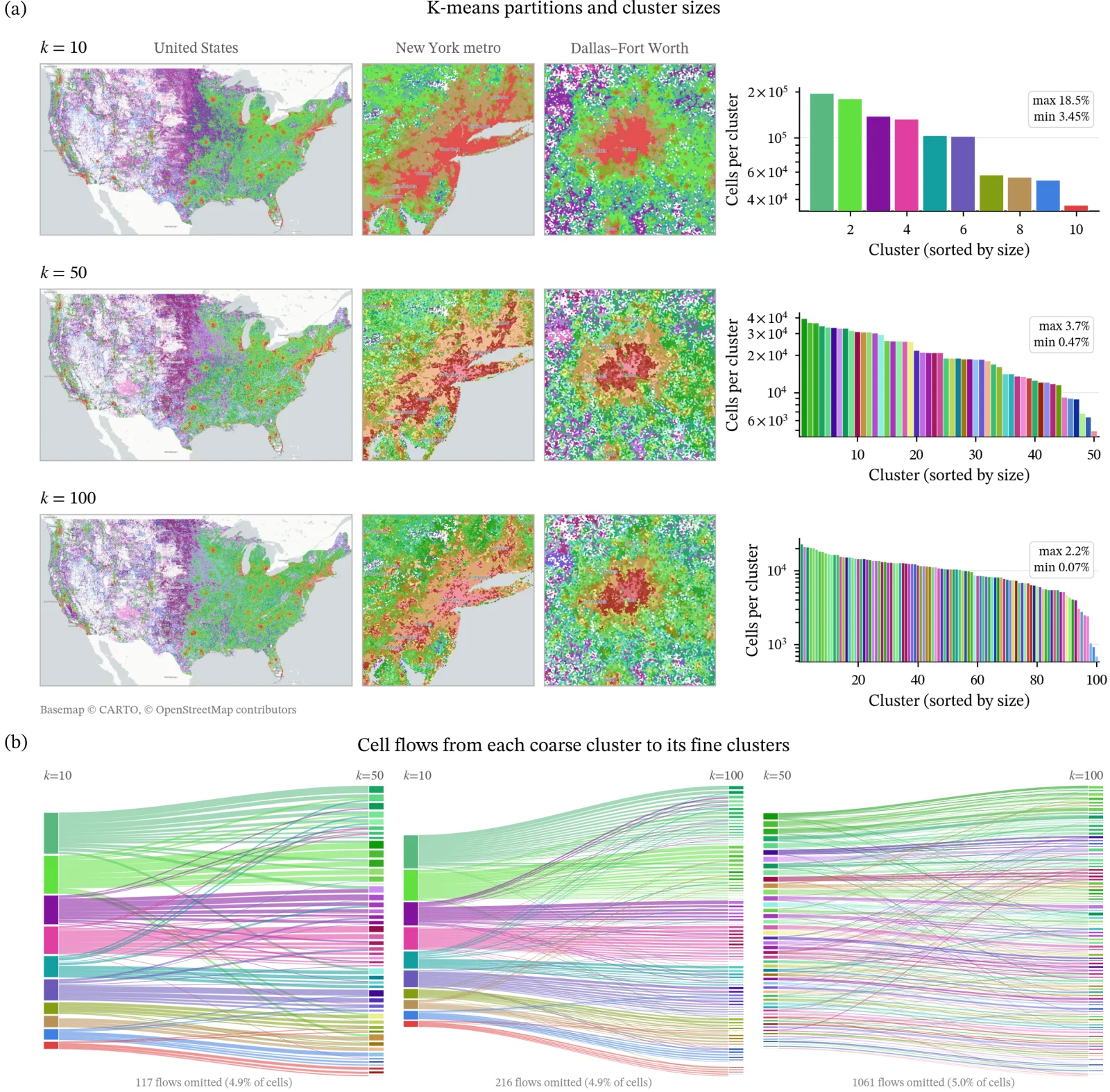
Spatial evaluation of PlacePulse Embeddings.
Insight 3: structure and behavior see different things
We tested the embeddings as features on 74 held-out targets from 12 outside sources, across four spatial units, always with the same gradient-boosted model and cross-validation that holds out whole states. Nothing in that battery was used in training.
We compared its performance with Google’s Population Dynamics Foundation Model, which learns from aggregated search trends, points of interest and their busyness, weather and air quality, and satellite-derived embeddings. The results varied by domain:
- PlacePulse leads on health (R² 0.610 against 0.573) and economic status (0.633 against 0.605), the outcomes that depend on persistent social and institutional structure.
- PDFM leads on points of interest (0.906 against 0.784), physical geography, and entrepreneurship, the outcomes tied to observable activity and physical form.
- Performance was similar on population activity and social capital.
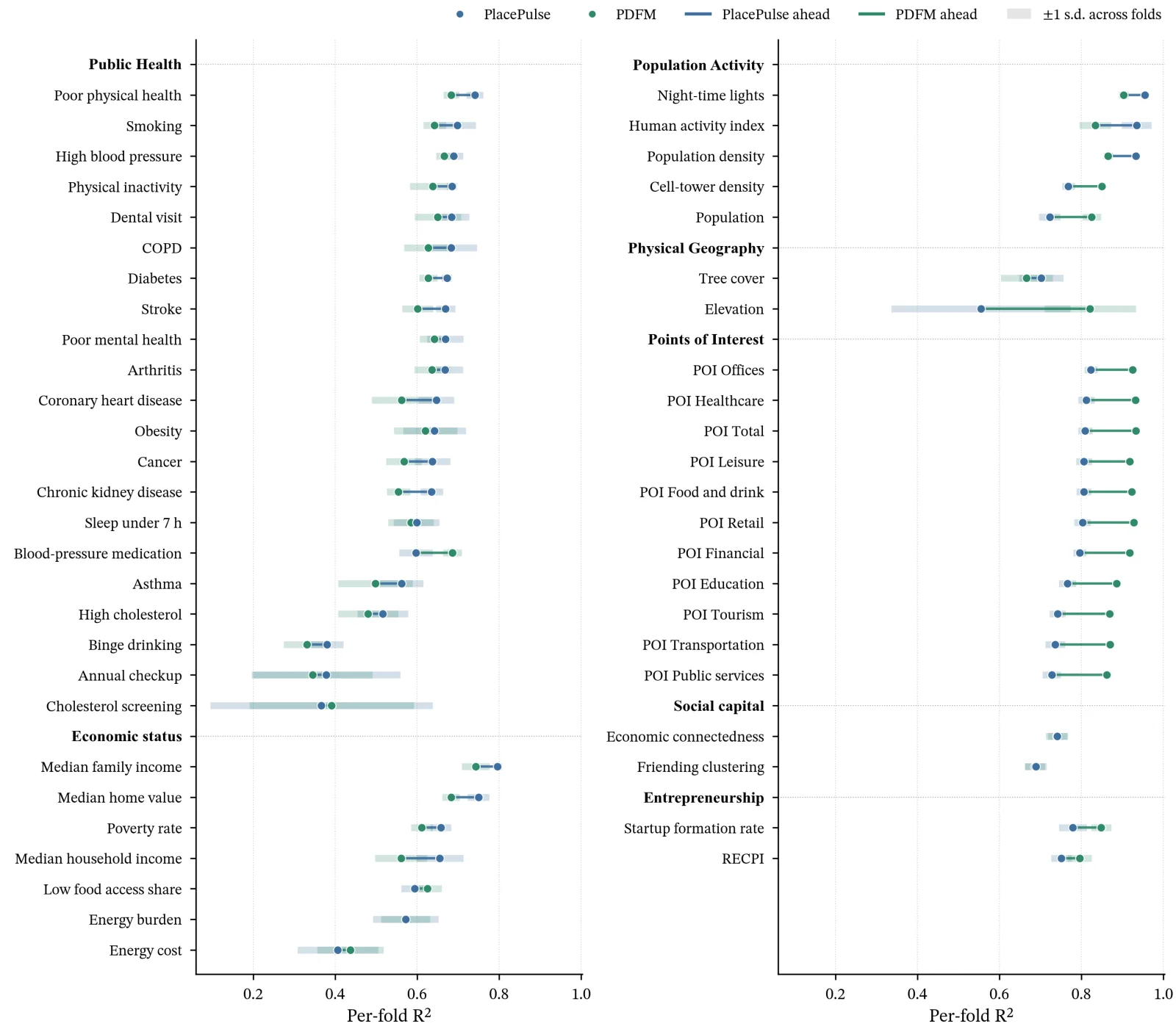
Downstream task evaluation of PlacePulse Embeddings and PDFM.
These results suggest that structural and behavioral data offer complementary perspectives on place. Each representation has strengths across different prediction tasks, making their combination a promising next step. Whether combining them improves performance is a question for further evaluation.
What you can do with PlacePulse
A single 256-dimensional vector turns every cell into a machine-readable description of place. That opens up four ways to work with geography:
- Retrieve → Find similar places. Every embedding sits on the unit sphere, so cosine similarity can be computed as a dot product. That makes it possible to search large areas efficiently: start with a place you understand, and find the places that resemble it. Use this for everything from finding twin markets and expansion opportunities to tracking how places change when embeddings are compared across time.
- Predict → Fill the gaps. Embeddings can serve as features in predictive models. Train a model where you have observations, then use it to estimate the same variable in places where it has never been measured. This can help fill gaps in sparse datasets or extend a survey from a few hundred locations to an entire country.
- Describe → Understand place types. Embeddings also provide a way to explore the structure of geography itself. Cluster places to reveal distinct place types, measure how typical or unusual each location is, or compare cells with their neighbors to identify transitions and boundaries. The result is a richer understanding of how places are alike, different, and changing.
- Reason → Give spatial AI a representation of place. Embeddings give AI a way to reason about places using data, not just text. An AI Agent can use them to compare locations, rank opportunities, identify patterns, and connect spatial characteristics to business questions so the embedding becomes a common spatial language that AI can use to move from a business question to a geographic answer.
Similarity Search app that uses PlacePulse to look for similar locations in the US.
If you are interested in knowing more, explore our series of blog posts:
- PlacePulse Embeddings: a Fingerprint for Every Place in the US
- Building a Retail Fingerprint with PlacePulse Embeddings
- Finding the Next EV Charging Hotspots with PlacePulse Embeddings
- From embeddings to spatial insights: Five new tools in CARTO Workflows
Read the paper
If you want to go deeper, the full paper includes the model architecture, training setup, benchmark design, and per-target results: PlacePulse: Learning Transferable Place Representations from Structural Geographic Data.
PlacePulse is built to make geospatial foundation models practical for real-world analysis, from finding similar places to predicting outcomes in new locations. Want to see what it can reveal about your own footprint? Request early access.