Public sector: The spatial analytics upgrade hiding in your Oracle Database



Ask any government IT director what it would take to modernize their agency's mapping and spatial analysis operations, and the answer usually starts with a budget line for a new platform, followed by a procurement cycle, a migration plan and perhaps a new vendor relationship on top of the dozen the agency already manages. It's a lot.
For many Oracle users in the public sector, that entire process is actually completely unnecessary. The spatial capability they're trying to buy is already sitting inside the database they're already using for financials, procurement, and asset management. They just haven't turned it on.
You've already done the hard part
Oracle has supported spatial data types, indexing, and network analysis since the early 1990s, and its Autonomous AI Database runs that spatial engine today as a self-driving, cloud-native service. What's usually missing isn't the database capability. It's opening up spatial analysis to the non-specialists who actually need it to drive decisions. Rather than being blocked waiting for GIS analyst availability, they need access to repeatable analysis instead of one-off requests.
That's where CARTO comes in.
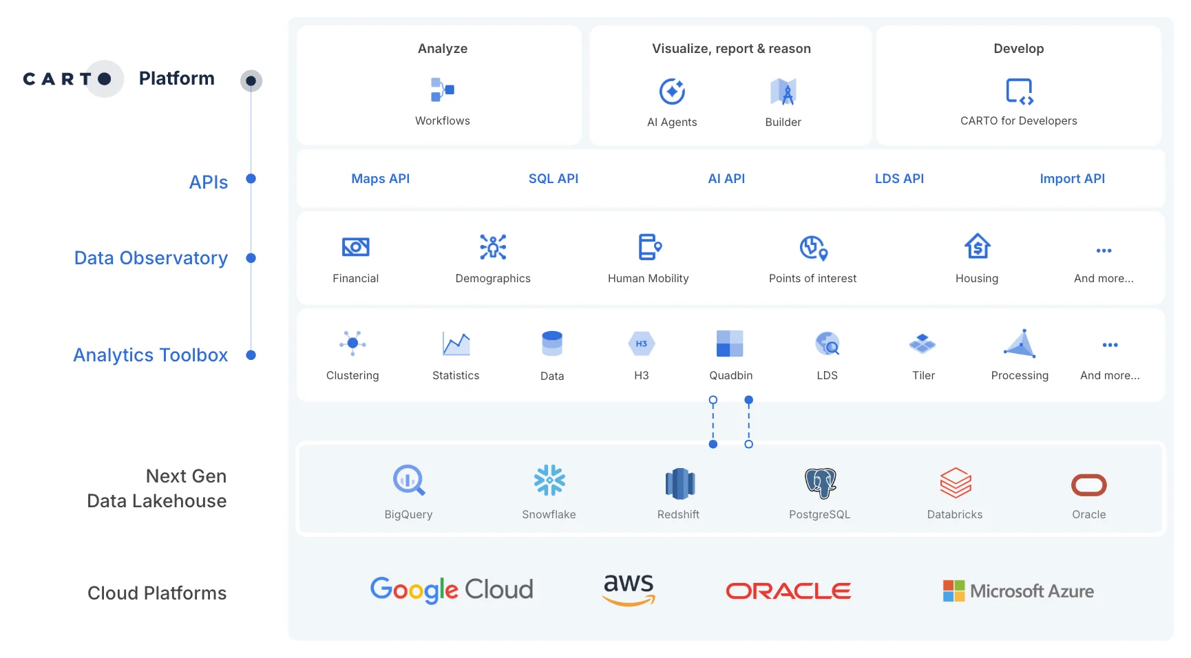
CARTO is designed specifically not to require any data migration from Oracle; all processing happens directly inside Oracle, with no copying data out to a different platform and no ETL pipeline to build and maintain. Agencies typically set up a virtual or physical data warehouse inside their existing Oracle Cloud environment, pull in the systems they want to analyze, and keep the same security boundaries they already have.
The bottleneck isn't the data, it's the queue
Most government agencies aren't short on geographic data. They have parcel records, infrastructure inventories, census data, service request logs, all of it tied to a place. What they're short on is people who can turn that data into an answer fast enough to matter.
It's this queue, not the underlying technology, that is usually the real cost of legacy GIS. By the time the analysis comes back, the budget cycle has moved on and the decision has been made without it.
From one-off requests to self-service answers
Clearing that queue isn't about adding another dashboard on top of the problem. CARTO's value is that the analysis a GIS specialist would otherwise rebuild by hand for every request instead gets built once as an AI Agent and reused on demand. All of this happens natively inside Oracle. A GIS analyst's expertise still drives the process: designing the Agent, formulating the analysis, and validating the output.
Rather than guessing, the AI Agent responds to plain-language questions by running the specific tools the GIS analyst specified against current data, analysis and maps. It returns the result along with the query behind it, so it can be checked before anyone acts on it. The decision-makers get instant answers, the GIS specialist focuses on building and refining Agents to extend their own impact, and the queue disappears.
Driving impact in the public sector
So what could this look like in practice? During our recent webinar with Oracle, we explored how a city could use Agentic GIS to deliver value across three separate departments:
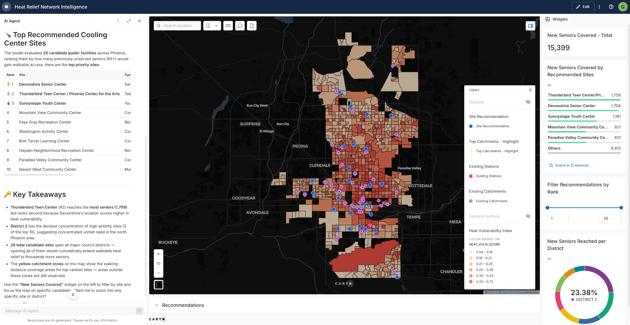
Public health. Instead of guessing where to place cooling centers, cities could run a site selection analysis that scores locations against heat vulnerability, using age and income data alongside the coverage area of existing centers.
Public safety. Fire station coverage gets mapped using six-minute response zones, showing exactly which areas fall outside that window and where a new staging site would close the gap.
Infrastructure. Storm drain inspections get prioritized with a composite score built from location, flood risk, and inspection history, so maintenance crews know which drains to check first instead of working through a list in whatever order it was written.
Watch now: 3 Ways Governments Can Better Serve Their Citizens With Spatial Analytics
Each one follows the same pattern described above: an Agent is built once by an analyst, and then made available to anyone who needs an answer, always running against live data rather than a static report. Here's a closer look at one of these examples.
Storm drains: from spreadsheets to self-service
For many cities, prioritizing storm drain inspections often means ranking every drain against location, flood risk, and inspection history by hand in a spreadsheet, then filing a separate request to get that ranking turned into a map. Two steps, two waits, before a crew could act on it, far from ideal when working against ever-changing weather conditions.
With CARTO working in Oracle, a GIS analyst builds that ranking criteria just once, as a single composite score combining location, flood risk, and inspection history. They then package this into an AI Agent anyone on the team can ask questions of directly. The Agent runs the score against the city's live Oracle data every time it's asked, so the answer is never more than a question away and never further out of date than the source data itself.
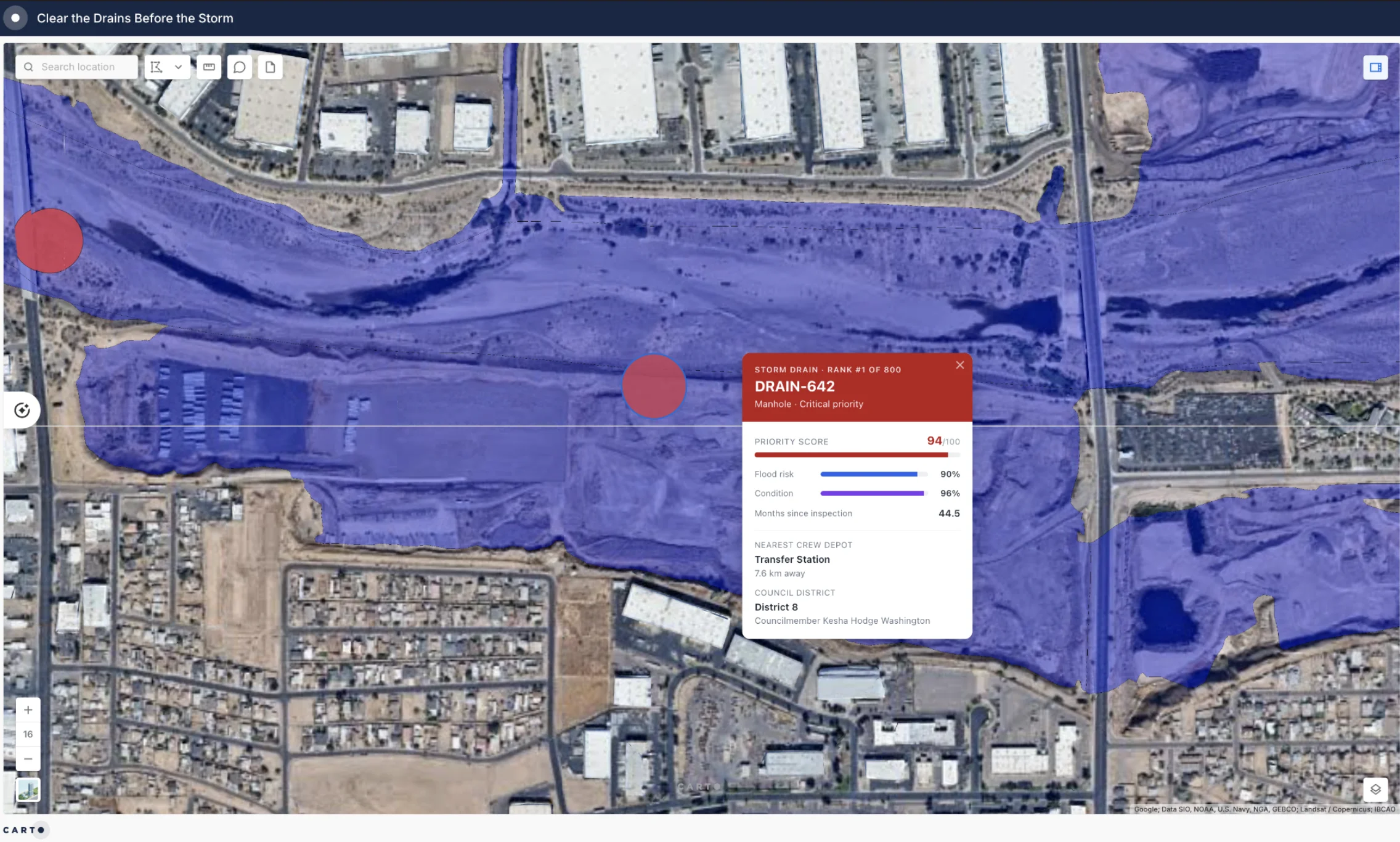
Now a maintenance supervisor can ask the map something like "which drains in District 3 need inspection first?" and get, in one exchange, a ranked answer, the reasoning behind it, and the map to go with it, all pulled from the same live Oracle data in minutes. This is exactly the kind of answer that used to mean a static spreadsheet, a request ticket and a long wait, and is now available on demand.
Start small, prove it, then scale
The teams getting the most out of this aren't starting with everything at once, but starting with projects that are small enough to pilot without touching core systems, and specific enough to show a result an agency can point to before expanding further. This could include evidence-based site selection tied to real funding decisions, and high-visibility initiatives where citizens will notice whether the agency got it right.
If your agency already runs Oracle, the question isn't whether you can afford to modernize your spatial analytics, it's whether you're making the most of what you already have.
Request a demo to see how CARTO runs on your existing Oracle environment.
Frequently Asked Questions
Does Oracle Database support spatial analysis?
Yes. Oracle has supported spatial data types, spatial indexing, and network analysis since the early 1990s, and the Autonomous AI Database runs that same spatial engine today as a self-driving, cloud-native service. For most public sector agencies the missing piece is not the database capability, it is giving non-specialists a way to use it without waiting on a GIS analyst.
Do I need to migrate data out of Oracle to run spatial analytics with CARTO?
No. CARTO is designed not to require any data migration from Oracle. All processing happens directly inside the database, so there is no copying data out to another platform and no ETL pipeline to build or maintain. Agencies typically set up a virtual or physical data warehouse inside their existing Oracle Cloud environment and keep the security boundaries they already have.
How do CARTO AI Agents work with Oracle data?
A GIS analyst builds an analysis once and packages it as an AI Agent, specifying the tools the Agent is allowed to run. Anyone on the team can then ask the Agent a plain-language question, and it runs those tools against live Oracle data, returning the answer, a map, and the query behind it so the result can be checked before anyone acts on it.
What can public sector agencies do with spatial analytics in Oracle?
Common examples span departments: siting cooling centers by scoring locations against heat vulnerability, age and income data, and the coverage of existing centers; mapping fire station coverage using six-minute response zones to find the areas that fall outside the window; and prioritizing storm drain inspections with a composite score built from location, flood risk, and inspection history.
Does Agentic GIS replace the GIS analyst?
No. The analyst’s expertise still drives the process: they design the Agent, formulate the analysis, and validate the output. What changes is the request queue. Instead of rebuilding the same analysis by hand for every request, the analyst builds it once and reuses it, which frees them to extend their impact across more of the agency.