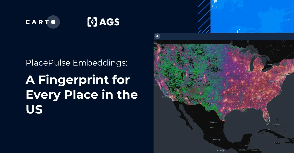
Satellite imagery you can query with LGND in CARTO


Satellite imagery is one of the richest sources of geospatial intelligence, but also one of the most difficult to work with. Manually reviewing satellite imagery tile by tile is slow, expensive, and doesn't scale to the global coverage most organizations need. The arrival of AI geospatial foundation models is changing that.
CARTO has partnered with LGND AI to bring their Embeddings API directly into CARTO Workflows as a ready-to-use extension package. The result is a set of drag-and-drop components that let analysts search, analyze, and detect change across satellite imagery; without writing a line of code and without needing a machine learning background. This integration expands CARTO's growing ecosystem of geospatial foundation model capabilities, building on our existing support for models like Google's PDFM and AlphaEarth, and brings satellite imagery search to operational workflows, making it possible to ask questions of the planet's surface at a scale and speed that was previously out of reach.
What Is LGND?
LGND provides an Embeddings API to access geospatial foundational models (GeoFMs), such as the open-source Clay model. The API lets users convert satellite imagery into vector embeddings: compact mathematical representations of what a place looks like at a given moment in time. It exposes a set of search endpoints to query those embeddings at scale.
Understanding Chip-Level Embeddings
To understand what makes LGND's approach powerful, it helps to understand how their underlying GeoFM "sees" the planet. Rather than processing entire satellite scenes at once, the model works with the concept of chips. These chips are small square sub-sections of imagery, typically 128×128 pixels. Each chip is converted into an embedding: a vector of numbers that captures the visual essence of that area. Think of it as a fingerprint for a patch of land.
This chip-level approach captures context and semantics, not just raw pixel values. A chip-level model doesn't just detect "grey rooftop pixels"; it recognises the broader pattern: school vs. factory, orchard vs. suburban neighbourhood. A school and a factory can both have grey roofs, but only one has basketball courts and a playground out front. Chip-level embeddings capture those distinctions.
Crucially, the Clay model uses single-timestamp embeddings: each embedding represents a specific location at a specific moment in time, rather than an annual average. This makes it well suited to detecting dynamic, short-term changes on a daily or weekly cadence.
Satellite imagery analysis, built into your pipeline
The LGND Embeddings Extension Package for CARTO Workflows exposes LGND's API endpoints as no-code components. Once the extension is installed, analysts can incorporate satellite imagery intelligence into any analytical and data processing pipeline.
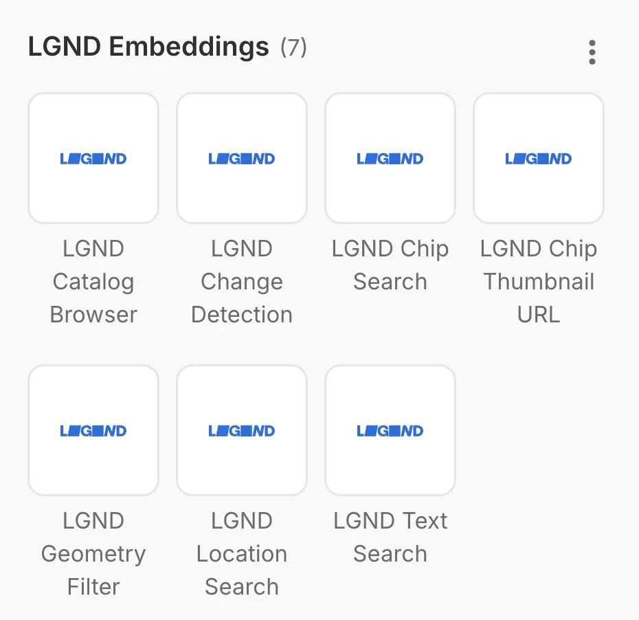
The extension package includes seven components:
- Text Search: find chips that match a natural language description (e.g. "construction site with heavy machinery")
- Chip Search: find chips that look similar to a known reference chip
- Location Search: find chips that look similar to a given lat/lon point
- Change Detection: identifies locations where the landscape has visibly changed between two states described in text
- Geometry Filter: retrieve all chips within a polygon; no similarity search is performed
- Catalog Browser: discover which imagery collections are available for your account
- Chip Thumbnail URL: generate viewable thumbnail URLs for any set of chip IDs, for use in CARTO Builder
Each component accepts credentials and query parameters as inputs, and outputs a standard table that flows directly into the rest of the workflow.
Note that currently the LGND extension package for Workflows is only available for CARTO Data Warehouse and Google BigQuery connections. In order to work with the extension package in CARTO, you will need valid LGND API credentials (i.e. api_token & tenant_id, collection_id); sign up at developer.lgnd.ai.
From images to insights: use cases across industries
Once satellite imagery becomes searchable - not by metadata or date, but by visual meaning - any workflow that previously required a team of image analysts reviewing tiles manually can be replaced by a query.
With a single prompt, you can detect deforestation, spot emerging construction, or rank disaster-hit properties by severity; all at continental scale, in minutes. You can also set up "monitoring" workflows that refresh the search each time new imagery becomes available.
The three examples below show what that looks like in practice across industries where Location Intelligence is already core to the business, such as insurance, real estate, or telco.
Post-disaster claims triage
After a wildfire, insurers face thousands of simultaneous claims and need to direct field adjusters to the most severely impacted properties first.
Using CARTO Workflows and the LGND extension package, an analyst can run a Text Search across a portfolio of insured assets querying for "burn scar, burned houses, scorched structures". Each result carries a similarity score reflecting how closely the imagery matches the damage description, which can be used to compute a potential damage score that ranks assets by their proximity to high-scoring chips.
The result is an objective, automated triage system that prioritizes field resources before a single site visit; compressing a process that would otherwise take days of manual image review into a fully repeatable pipeline.
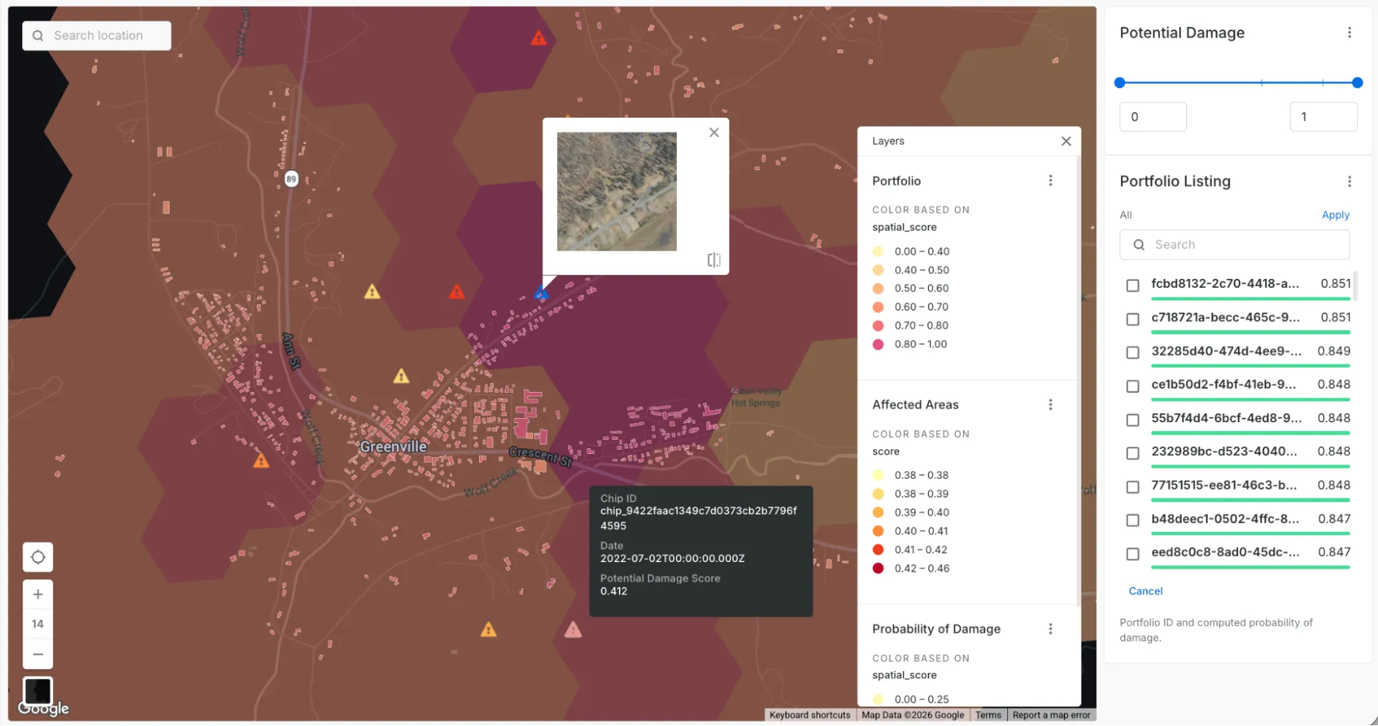
Showcasing LGND Embeddings Extension Package: Post Disaster Claim Triage. Click on the caution signs to view satellite imagery showing damage in an area.
Identifying undeveloped land in high-growth markets
Real estate investors need to find undeveloped land in markets where demand is rising faster than supply. Timing matters: acting too early means betting on markets that may never materialize; acting too late means competing for land that is already priced in.
This workflow combines home value appreciation data (Zillow Home Value Index) with satellite imagery to automate site prospecting. Zip codes are first scored and ranked by opportunity; weighting both absolute and relative price growth to balance high-value established markets against emerging ones. The top-ranked areas then become the spatial boundary for a Text Search query, surfacing chips that visually match patterns of undeveloped land: "bare soil," "graded land," "undeveloped lots." Analysts can optionally refine results by providing known reference chips as positive or negative examples, and visualise all candidate sites directly in CARTO Builder using the Chip Thumbnail URL component.
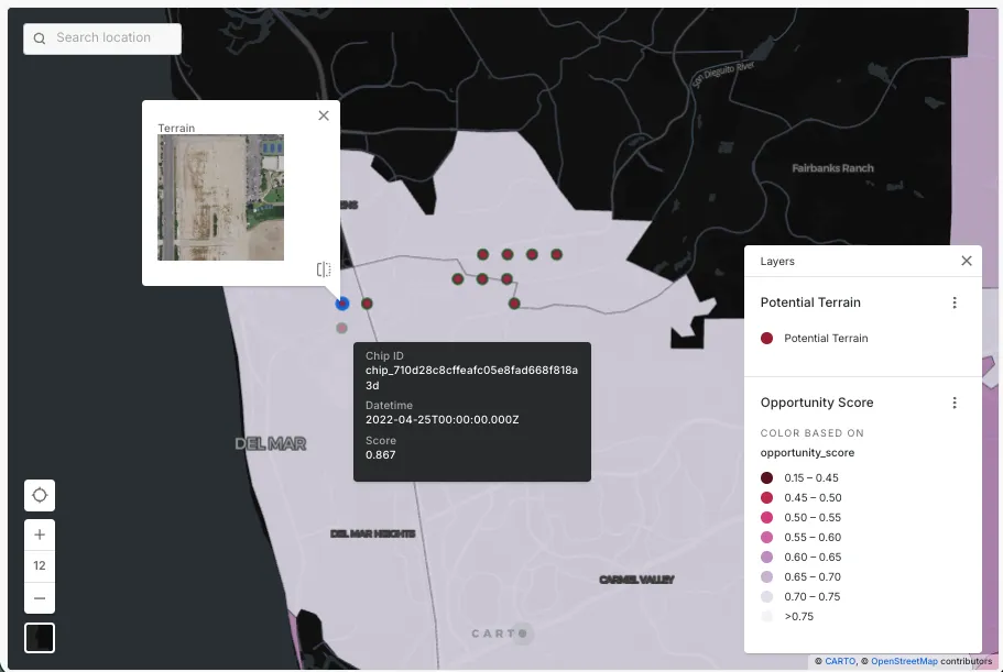
Showcasing LGND Embeddings Extension Package: Identifying Undeveloped Land in High-Growth Markets. Click on flagged (red circles) regions to view satellite imagery showing current terrain.
Prioritizing fixed broadband rollout
Telco operators planning fixed broadband infrastructure need to identify areas that are rapidly urbanizing but still underserved by coverage. Using Change Detection, this workflow identifies chips showing new housing developments and densifying neighbourhoods ("wasteland, bare soil, sparse vegetation, open field" past descriptions vs "buildings, roads, dense residential neighborhood" current descriptions), then cross-references those results with existing coverage maps. Areas with high visual change and no current connectivity become the top deployment candidates. Building infrastructure ahead of demand saturation at those locations maximizes subscriber acquisition at the lowest cost per connection.
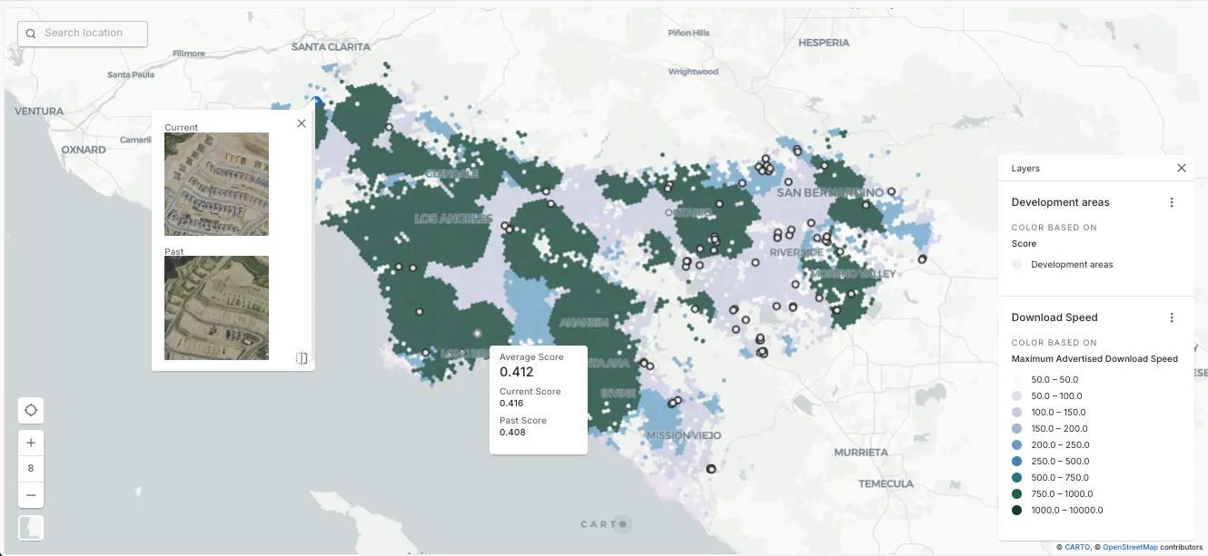
Showcasing LGND Embeddings Extension Package: Prioritising Fixed Broadband Rollout. Click on flagged (white circles) areas to view satellite imagery showing how these locations have changed.
Farewell manual satellite imagery analysis
Satellite imagery has always promised a window into the world: a live, global record of how the planet looks, changes and behaves. However, using it at scale required specialized infrastructure and engineering effort that many analytical teams didn't have.
LGND's integration in CARTO Workflows closes that gap, turning that window into a powerful decision-making tool. With geospatial foundation models, you can now search satellite imagery by text, location, or visual similarity and combine those results with your existing data to unlock new insights, bringing imagery intelligence directly into your analyses.
Ready to put satellite imagery to work? Start your free 14-day trial here and explore CARTO Workflows and the LGND Embeddings Extension Package today!