What Exactly Is Big Data? And Why Location Matters


What exactly is big data? The term gets thrown around constantly, but a clear definition is surprisingly hard to pin down. If you work with data at any scale, understanding what big data actually means (and what makes it spatial) will change the way you approach analysis.
Big Data, Defined Simply
Big data describes a situation where the volume, velocity, and variety of data exceeds what traditional tools can store, process, or analyze effectively.
Think of a dataset with millions of GPS pings updating every few seconds, combined with satellite imagery, sensor readings, and point of sale logs across large geographies. That mix of size, speed, and format is big data. But collecting it is only half the story. The real challenge is extracting what’s relevant and turning it into decisions fast enough to act on.
Why Most Big Data Is Spatial Data
Experts estimate that 80% of all data has a spatial component. Every delivery route, insurance claim, mobile signal, and customer transaction happens somewhere. Yet most organizations analyze only a fraction of this spatial data because traditional desktop platforms can’t handle the volume and scale.
What good is storing terabytes of geospatial data if you can’t query it in full context? Or if results take hours when you need answers in minutes?
This is the gap that cloud-native spatial analysis fills.
How CARTO Handles Big Data
CARTO is built to analyze spatial data at any scale, directly inside your cloud data warehouse. Instead of copying data to external servers, CARTO runs analysis where your data already lives: in Google BigQuery, Snowflake, Databricks, Amazon Redshift, Oracle Autonomous DB, or PostgreSQL.
This cloud-native approach means:
- Billions of rows, no bottleneck. CARTO’s dynamic tiling technology, pregenerated tiles, and spatial indexing (H3 and Quadbin) let you visualize and analyze datasets with billions of points without moving data out of your warehouse.
- Your governance stays intact. Security policies, role-based access, and audit trails from your data warehouse apply automatically. No data duplication, no shadow copies.
- Analysis at warehouse speed. The Analytics Toolbox provides 100+ spatial functions (geocoding, clustering, hotspot analysis, enrichment) that run as native SQL inside your warehouse.
From Raw Data to Real Answers
Big data only creates value when you can act on it. CARTO gives teams multiple ways to go from raw spatial data to answers:
- CARTO Workflows lets analysts build spatial analysis pipelines visually, without writing code.
- CARTO Builder turns warehouse queries into interactive maps that update in real time.
- AI Agents allow anyone to ask spatial questions in plain language and get map-based answers instantly.
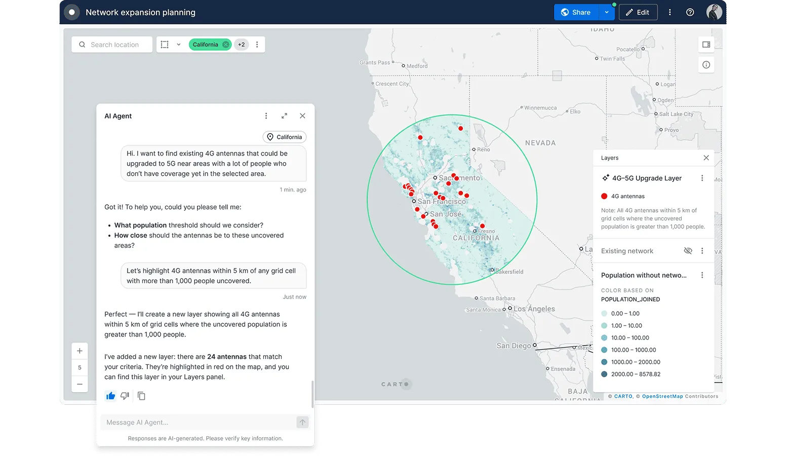
Whether you’re a data scientist building site selection models, a GIS professional processing nationwide parcel data, or a business team exploring market coverage, you can work at whatever scale your data demands.
Learn More: Resources to Get Started
If you want to go deeper into spatial analysis at scale, these resources are a good next step:
- CARTO Academy offers free, hands-on courses covering everything from building interactive maps to advanced spatial analytics with the Analytics Toolbox.
- Introduction to the Analytics Toolbox is a guided tutorial for running your first spatial analysis directly in your data warehouse of choice.
- CARTO Documentation covers the full platform, including Workflows, Builder, CARTO AI Agents, MCP Tools, connections, and API references.
Big Data Needs a Spatial Platform Built for Scale
The definition of big data hasn’t changed much since the term was coined. What has changed is what you can do with it. Cloud-native platforms that connect directly to your data warehouse have removed the old tradeoff between data volume and analysis speed.
If your organization sits on large spatial datasets and wants to turn them into decisions, request a demo to see how CARTO handles big data where it lives.
Editor’s note: This post was originally published in April 2016 and has been completely revamped and updated for accuracy and comprehensiveness.