Why spatial work feels slow, and how AI in GIS is changing that


We’ve all been there. Someone asks for a “quick map.” It’ll just take you thirty minutes, they assure you. Three weeks later, map_v7_final_FINAL ships. By then the question has moved on, the stakeholder wants the same thing for a different region, and the GIS team’s backlog has tripled.
If that sounds familiar, the problem isn’t your team. Building spatial things still feels slow. Sometimes painfully slow. The work is spread across tools that don’t talk to each other, depends on scarce specialist skills, and has to be rebuilt from scratch every time the question changes. Your team of talented GIS experts is tied up with busywork.
AI in GIS promises to fix that, and in places it does. But most of it speeds up the first draft, and the gap between that first draft and map_v7_final_FINAL is where the bulk of GIS time sits.
This post looks at where the time actually goes, why the first wave of AI tools hasn’t closed the gap, and what fast can actually look like.
Why does spatial work take so long?
Three things slow spatial work down more than anything else — and they make each other worse.
Too many tools that don’t talk to each other
The State of Spatial Analytics 2026 report found that most teams doing spatial work rely on between three and eight tools, and fewer than 20% are using just one tool.
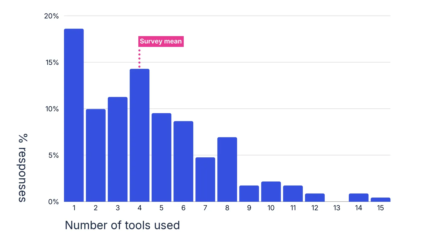
Your data lives in a cloud warehouse, the analysis happens in desktop GIS, the scripts sit in a Python notebook on someone’s laptop, and the finished map gets published to a separate web portal. None of them look at the same data source, so every hand-off is an export, an import, and a format conversion.
That means the data has to move before anyone builds anything. It gets copied out of the warehouse, reshaped for the GIS, and synced back when something changes. This is slow, a governance nightmare, and rife with risk. Nearly 30% of GIS professionals name data access and integration delays as their single biggest obstacle. That’s time spent getting ready to work, not working.
Too few specialists
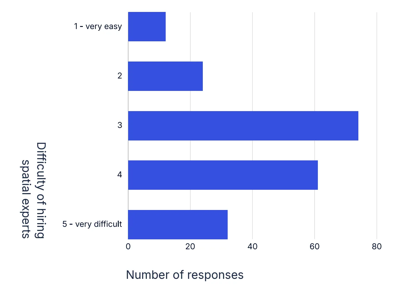
Building anything spatial still takes specialist know-how. An analyst needs to know which toolbox holds the right tool, the exact order of geoprocessing steps, and how to style the result so it reads clearly. A developer needs the platform’s SDK and scripting language on top of that. Those skills are hard to find: 46% of GIS professionals say hiring spatial talent is difficult or very difficult. This means every new map, workflow, or app joins a queue behind the same few people.
And it isn’t only new spatial analysis. A large share of an analyst’s week goes on small follow-up questions, such as “what about this area?” or “can you rerun it for last year?”, each of which pulls them away from the work only they can do.
The rebuild loop
It’s never “just” one map.
The brief changes: expand the study area, switch from a 10-minute to a 15-minute drive time, use five years of data instead of one. Each change sounds small, but in most toolchains it means rerunning every step of the analysis, re-exporting, and editing the map by hand. Any GIS analyst will tell you how much time they spend changing the text in legends and marginalia.
The project that you thought was finished is back at square one.
Hasn’t AI in GIS already fixed this?
Almost every GIS tool now has AI in it somewhere, so why isn’t this fixed?
Esri has added a growing set of AI assistants across ArcGIS: one for designing Survey123 forms, one for writing Arcade expressions, one that generates Python in ArcGIS Notebooks, and a beta assistant that generates code and runs actions in ArcGIS Pro. Felt’s AI turns a question into a map by working out the spatial operations needed and generating the queries “from scratch” (in Felt’s own words) against your warehouse.
These are useful, especially for a fast first draft. But they tend to leave the three problems above in place.
- AI inside each tool doesn’t join the tools up. An assistant per product makes each step quicker, but the data still has to move between them. The exports, imports, and format conversions are all still there, just with a chat window on top.
- AI moves the specialist bottleneck instead of removing it. Assistants can get you to a convincing first draft fast, but someone still has to know what good looks like: whether the method is right, the data is current, and the map tells the truth. So the queue doesn’t disappear. It moves up the chain to the senior analysts who have to review every draft, and they’re the people your team can least afford to slow down.
- Every change still sends you back to square one. When the brief changes, an assistant can rewrite the query or regenerate the map, but leaves a lot of manual work in place. Moving from a 10-minute to a 15-minute drive time can still mean rerunning each step, re-exporting the results, and fixing the legend, title, and marginalia by hand. And because each run is generated fresh, the updated version can quietly differ from the last one in ways nobody asked for, so it all needs checking again.
That’s the gap: 45% of respondents use AI as an individual productivity tool, but only 18.3% have it embedded in their processes. AI that writes a fresh first draft helps one person, once. It doesn’t make the next build any faster.
What does fast actually look like?
Fast doesn’t mean skipping the expert. It means cutting the busywork and the endless “can you just…” requests, so experts build each spatial thing once and reuse it everywhere. Three shifts are worth aiming for.
1. Describe it, don’t click through it. You should be able to say what you want in plain language, for example “Make me an H3 density map of NYC collisions (carto-demo-data.demo_tables.nyc_collisions) in CARTO Builder and share it here” and get a working analysis and map back. When the brief changes, saying so should update every piece, from the analysis to the legend. That saves real time on one map, and it changes everything when you have 100 to update.
💡 The NYC collisions data used here is available via the CARTO Data Warehouse for all customers, so you can give this exact example a go with a free CARTO trial!
2. Bring the answers to where people already work. Spatial work shouldn’t mean asking everyone to open a specialist GIS application. Planners, operations leads, and directors already spend their days working in AI platforms. The goal is for a spatial question to get answered where it’s asked, without a GIS license or a ticket. Every question colleagues can answer themselves is time an analyst gets back.
3. Make every build reusable. Analysis should end up as a fixed workflow, not a one-off query. That way it gives the same answer every time, anyone can check how it got there, and it can be published as a tool the next person calls. The second build should start where the first one finished.
How CARTO speeds up spatial building
CARTO accelerates GIS analysis across your whole team. It runs inside your cloud data warehouse so there’s no data to move before you start and nothing to sync afterwards. It’s built around the three shifts that are making spatial analysis faster than ever:
Describe it. With CARTO for Agents, GIS analysts can build and update maps, workflows, and apps in plain language. A new study area, a longer drive time, or another year of data is one request, not an afternoon of reruns, exports, and legend edits. The analysis, the map, and the marginalia all update together.
Bring it to where people work. Analysts can turn any workflow into a tool colleagues can use from the AI assistants they already have, including Microsoft Copilot, ChatGPT, and Claude. Or they can add an AI Agent to a map, so people ask it questions instead of sending another request. The analyst builds it once, and everyone else gets answers without joining the queue.
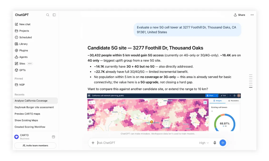
Make it reusable. Agents call CARTO’s deterministic tools instead of writing fresh SQL each time, and any workflow can be published as a tool the rest of the team can call. Every answer can be repeated and checked.
The difference shows up quickly. One global logistics company using CARTO cut an analysis from two to three weeks down to two hours, and a global manufacturer reduced map creation time by 95%.
A quick test for your own team
Time a GIS project, from kick-off to completion. Note how much of that was repeating work you’d already done once, or fielding questions from colleagues that a self-service tool could have answered. That number is the size of the opportunity.
Request a demo to see your team go from question to finished map in minutes.
Frequently Asked Questions
Why does building GIS maps and workflows take so long?
Three reasons that compound each other. Spatial work is spread across three to eight tools that don’t share data, so every hand-off is an export and import. It depends on scarce specialists, with 46% of GIS professionals saying spatial talent is hard to hire. And every change to the brief means rerunning the analysis and editing the map by hand.
Hasn't AI in GIS already solved this?
Not yet, for most teams. AI assistants inside individual GIS tools speed up the first draft, but data still moves between tools, senior analysts still review every draft, and a changed brief still means rework. 45% of respondents use AI as an individual productivity tool, but only 18.3% have it embedded in their processes.
How does CARTO make spatial analysis faster?
CARTO runs inside your cloud data warehouse, so no data needs to move. With CARTO for Agents, analysts build and update maps, workflows, and apps in plain language, and can publish workflows as tools colleagues use from Microsoft Copilot, ChatGPT, or Claude. Agents call deterministic tools, so every answer can be repeated and checked.
How can I measure how much time my GIS team could save?
Time a GIS project from kick-off to completion, then note how much of it was repeating work already done once, or answering colleagues’ questions a self-service tool could have handled. That share is the size of the opportunity.