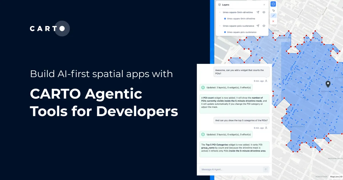
6 best practices for adopting AI in Spatial Analytics

6 best practices for adopting AI in Spatial Analytics

Learn 6 best practices for integrating AI into spatial analytics. Establish a secure, scalable AI strategy to automate tasks and make confident decisions.

Spatial Analytics

In your cloud

News

What’s New in CARTO - Q2 2025

Use cases

Create your expansion strategy with CARTO and Snowflake

Revisiting Cesium

Revisiting Cesium

Welcome Roger!

Welcome Roger!

Geoprocessing with PostGIS - Part 1

Geoprocessing with PostGIS - Part 1

Explore geospatial magic with CartoDB! Learn PostGIS functions for Convex Hulls and Buffers. Simplify mapping and analysis effortlessly.

Welcome Stuart!

Welcome Stuart!

CartoDB & Digital Globe Take a Selfie from Space!

CartoDB & Digital Globe Take a Selfie from Space!

Advanced Mapping with the GDELT API + BigQuery

Advanced Mapping with the GDELT API + BigQuery

SOTMUS 2015 x CartoDB!

SOTMUS 2015 x CartoDB!

Map of the Week: Making Rent

Map of the Week: Making Rent

2015: The Year of Pizza!

2015: The Year of Pizza!

Making Maps with GDELT + CartoDB

Making Maps with GDELT + CartoDB

Map the world's news in real-time with CartoDB and GDELT! Explore global events, emotions, and trends.

Take Flight with EBP and CartoDB for Europe's Green Week 2015

Take Flight with EBP and CartoDB for Europe's Green Week 2015

Explore bird distribution patterns with the EuroBirdPortal project, powered by CartoDB. Visualize migratory patterns, phenology, and more.

The Spanish Regional and Municipal Elections: CartoDB Powers Real-Time Results

The Spanish Regional and Municipal Elections: CartoDB Powers Real-Time Results

Academy

6 best practices for adopting AI in Spatial Analytics

Learn 6 best practices for integrating AI into spatial analytics. Establish a secure, scalable AI strategy to automate tasks and make confident decisions.

Spatial Analytics

Branch out: new control components for more resilient workflows

Discover CARTO Workflows’ new Conditional & Success/Error Split components to build flexible, resilient spatial analysis pipelines.

Spatial Analytics

From Imagery to Insight: Google AlphaEarth Foundations in CARTO

Discover how CARTO integrates Google DeepMind’s AlphaEarth satellite embeddings for advanced geospatial AI, climate, and risk analysis.

Spatial Data Science