CUSTOMER STORIES

Understanding Spatial Trends of London’s Road Accidents

CARTO has allowed us to tackle complex challenges relating to road accident analysis in London and much more. Working with their cloud-native platform has been a transformative experience, making it faster for us to visualize large-scale geospatial data and quickly deliver insights to different areas of our business, partners, and clients.
Val Ismaili
Transport Planner at ARUP
CARTO has allowed us to tackle complex challenges relating to road accident analysis in London and much more. Working with their cloud-native platform has been a transformative experience, making it faster for us to visualize large-scale geospatial data and quickly deliver insights to different areas of our business, partners, and clients.
Val Ismaili
,
Transport Planner at ARUP
The Client
ARUP
ARUP is a global, independent firm known for its pioneering work in the fields of engineering, design, and consulting. With a rich history spanning over seven decades, their designers, consultants, and experts are working on sustainable development across 140 countries.
ARUP has built a strong reputation for delivering innovative and sustainable solutions that shape the built environment, improve quality of life, and address the world's most complex challenges.
The Challenge
Understanding Spatial Trends of London’s Road Accidents
ARUP's commitment to sustainable development includes enhancing transportation safety. In this context, ARUP faced the challenge of comprehending road accidents in London to support public administration in eliminating severe accidents and road collision-related deaths by 2041.
Achieving this goal required a comprehensive understanding of road accident trends, hotspots, and the underlying factors contributing to accidents. In the beginning, it seemed like there was an absence of a robust spatial data analysis framework, but it was a matter of finding the right software to identify locations and reasons behind these accidents.
Results
Granular Spatial Analysis to Reveal Hidden Patterns and Correlations
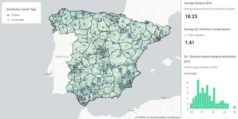
CARTO Builder ® was key for ARUP to conduct granular spatial analysis. By aggregating data into a grid and applying spatial autocorrelation techniques, ARUP identified hotspots of accidents, both in central and outer London. These insights not only provided a spatial context for accidents but also revealed hidden patterns and correlations that were previously elusive.
CARTO’s geospatial technology enabled ARUP to uncover crucial temporal trends in road accidents. This included identifying holiday-related dips in accidents and increased accident rates during the early morning hours. However, this is not the first time ARUP has used CARTO to visualize trends, discover insights, and impress their own customers. This data-driven approach has laid the foundation for more in-depth analysis by incorporating additional data sets, including demographics and infrastructure.
Why CARTO?
Fast Visualization of Trends and Insights
CARTO Builder ® facilitates the creation and sharing of interactive web maps, promoting seamless collaboration and broader sharing of insights. It is highly scalable and adaptable to the unique needs of each project. Whether it's analyzing road accidents in London or addressing other spatial data challenges, CARTO's solutions are versatile and capable of scaling with any business.