CUSTOMER STORIES
Using Location Intelligence to Improve Agricultural Sustainability

“CARTO makes map making easy. I can quickly pull the data in, get it on a map, do some light SQL and then share. Collaboration is easy and within a couple of hours we can have a really great visual product to share with decision-makers.”
Jason McVay
Data Scientist, Indigo Ag
“CARTO makes map making easy. I can quickly pull the data in, get it on a map, do some light SQL and then share. Collaboration is easy and within a couple of hours we can have a really great visual product to share with decision-makers.”
Jason McVay
,
Data Scientist, Indigo Ag
The Client
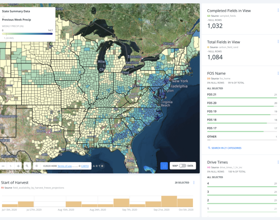
Founded in 2014, Indigo Agriculture works with growers to reimagine the entire agriculture system, from soil to sale. Their Grain and Transport Marketplaces help improve grower profitability, environmental sustainability, and consumer health through the use of natural microbiology and digital technologies.
The Challenge
As a part of Indigo’s data-driven approach to their business, they needed a solution that would allow them to pull in a wide range of datasets from Snowflake, turn complex geospatial data into actionable insights for business users, and deliver their analysis within tight business deadlines.
Results
Using the CARTO platform, Indigo Ag streamlined the way they collect, analyze and share spatial data. Using CARTO builder and CARTOframes, they are able to conduct faster internal prototyping, deliver daily insights with speed and increase reach through map-based analysis.
Find out more about CARTO & Snowflake’s connectivity here.
Why CARTO?
The seamless connectivity to Snowflake and user friendly nature of the CARTO platform has helped Indigo conduct their analysis with speed, saving valuable time and promoting collaboration between internal teams. By creating intuitive visualizations and maps, key stakeholders, who may not have experience with spatial analysis, are empowered to make data-driven decisions to support Indigo’s mission of helping farmers sustainably feed the planet.
+
A cloud-native approach
CARTO is the Location Intelligence platform built to run natively within your Snowflake AI Data Cloud. This seamless integration eliminates GIS data silos, enabling you to transform spatial analysis into actionable business insights directly inside your Snowflake environment.
CARTO’s platform eliminates slow and ungovernable ETL processes, and ensures enterprise-grade speed, scalability and security. Your geospatial teams gain native access to the full power of Snowflake’s scalable, multi-cluster architecture - including Apache Iceberg tables, Snowpark data engineering & ML and Cortex AI. CARTO extends Snowflake’s capabilities with rich geospatial visualizations, an advanced Analytics Toolbox, low-code design and automation, and app development tools - all available as a native app via the Snowflake Marketplace.