Site suitability analysis is a structured method for ranking candidate locations against multiple weighted spatial criteria to identify the most suitable place for a new store, facility, infrastructure asset, or advertising panel. Unlike a simple ranking by a single attribute, site suitability analysis combines many factors (demographics, accessibility, competition, environmental risk, regulatory constraints) into a single composite score for every candidate site.
What is Site Suitability Analysis?
The core idea is multi-criteria decision-making applied to geography. The analyst defines:
- A set of candidate locations (existing parcels, a grid of cells, points along a network)
- A set of criteria that should inform the decision (e.g. population within 10 minutes, distance to nearest competitor, household income, traffic counts)
- A weight for each criterion reflecting its importance to the decision
- A scoring rule for each criterion (linear, threshold, inverted) so all criteria are comparable on the same scale
The output is a suitability score for every candidate location, often visualized as a thematic map or ranked list.
This manual weighting approach, where an analyst sets the weights from expert judgment, is the most common framing. Weights and criteria can also be generated from data: statistical methods such as regression or machine learning models trained on historical site performance derive the weights rather than relying on expert judgment. In practice, teams sit somewhere on the spectrum between analyst-defined and data-driven weighting.
Common Criteria
- Demographic fit: population size, age distribution, income, household composition within the catchment
- Accessibility: drive-time, walk-time, public transit reach
- Competition: distance to nearest competitor, competitor density
- Existing customer base: proximity to known customers, often combined with trade area analysis
- Operational constraints: zoning, lot size, environmental risk, infrastructure availability
- Cost factors: property prices, lease rates, operating cost differentials
Why Site Suitability Analysis Matters
Decisions about where to place a store, a tower, or a billboard are usually expensive and hard to reverse. A structured suitability analysis forces the team to make weighting and trade-off decisions explicit, document them, and re-run the analysis when conditions change. It also makes the decision easy to defend, because every candidate is scored on the same criteria.
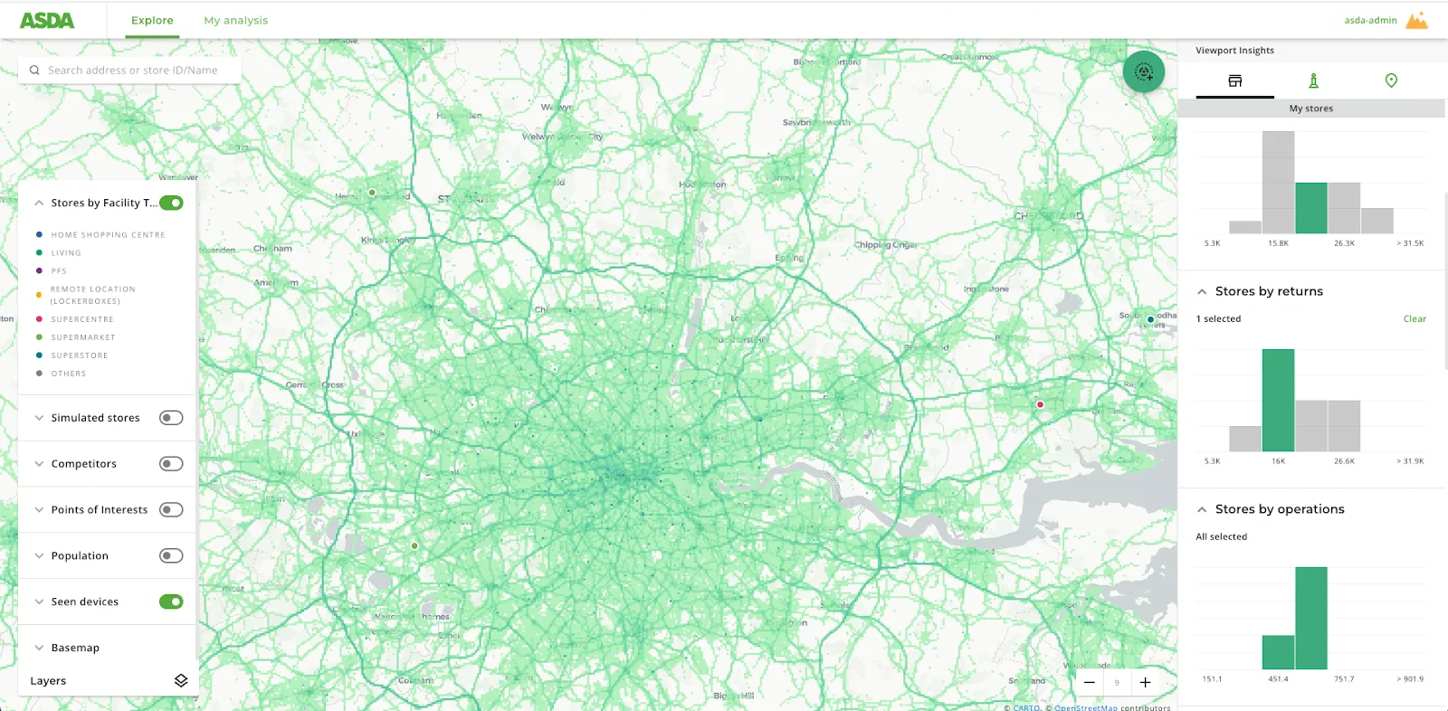
Site Suitability Analysis in CARTO
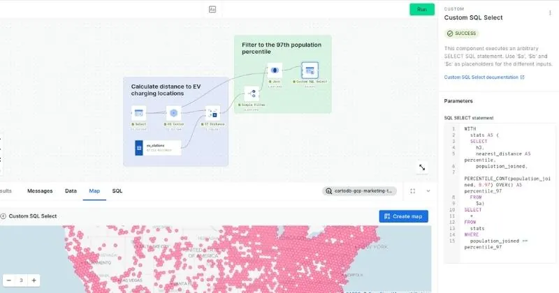
Site suitability analysis benefits from cloud-native spatial analytics. The CARTO Analytics Toolbox provides composite-score components that combine multiple normalized indicators into a single suitability index, directly inside BigQuery, Snowflake, Databricks, Redshift, and Oracle. Common patterns include:
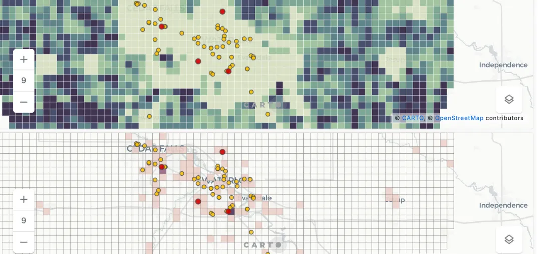
- Aggregating candidate locations to H3 or Quadbin cells for scoring at scale
- Enriching candidates with demographic, mobility, and POI data from the CARTO Data Observatory
- Weighting and combining scores in CARTO Workflows without writing SQL
- Visualizing the result in CARTO Builder for team review
Beyond Workflows and Builder, CARTO for Agents adds a new entry point that lowers the barrier even further. Using CARTO Agent Skills, analysts can run site suitability analysis conversationally: describe the business question in plain language inside the coding agent they already use day to day, have the agent recommend the right criteria, weights, and approach, and build out the relevant CARTO assets (a Workflow, a Builder map, or an MCP App) directly in the chat.
Use Cases
- Retail site selection: selecting the next store location from thousands of candidate parcels
- Telecommunications network planning: placing towers and small cells where coverage is needed and access is feasible
- Out-of-home advertising: ranking inventory by audience match and panel quality
- Real estate development: evaluating sites for residential, commercial, or industrial projects
- Renewable energy: finding suitable sites for wind, solar, and battery installations subject to grid, land, and environmental constraints
Site suitability analysis pairs naturally with trade area analysis: trade area analysis defines what each candidate catchment looks like, and site suitability analysis ranks the candidates based on how good those catchments are.