Posts by
Dan Rushton


Join CARTO at Leading Data Science, GIS, & Analytics Events
Join our team at upcoming events across the globe, including Big Data & AI World, Shoptalk, GEO Business, Home Delivery World, & Geospatial World Forum

Assisted Living Facilities Site Selection for Elderly Care
As the world’s population ages, discover how Assisted Living Facility owners & Private Equity can use CARTO for Site Selection to identify new optimal locations

Our Year In Review
Including the launch of a new cloud native version of our leading Location Intelligence platform & closure of a $61 million Series C round check out our recap of 2021!

Announcing the Spatial Data Scientist of the Year 2021
As #SDSC21 draws to a close today, we reflect on the conference & announce the winner of the Spatial Data Scientist of the Year Award!

Today Thousands of Spatial Leaders Gather for #SDSC21
#SDSC21 Online starts today! Join thousands of spatial leaders from around the world over 4 days to discuss & learn about the future of Spatial Data Science.

Climate Change & Extreme Weather: Hurricane, Wildfire, & Flood Maps
Climate change is contributing to extreme weather with increasing bursts of hurricanes, wildfires, & floods. See how maps can help plot, predict, & protect.

Using Location Intelligence to Ease the Supply Chain Crisis
The disruption of global trade flows & a shortage of drivers has led to a global supply chain crisis. Read how Location Intelligence can be a road out of the crisis.

Capturing the Sensitivity of National Wind Energy Potential to Local Siting Challenges
Wind energy is poised to be a significant contributor to national decarbonization goals, while there is enough wind available to power the nation, local siting challenges could have national implications. See how NREL is using location intelligence to better understand wind potential and it’s interaction with national clean energy targets.

A Look Back at 18 Months of COVID Grants & Maps
18 months since CARTO made it’s platform free to public & private sector organizations fighting coronavirus, we look back at some of the hundreds of grants.

Announcing CARTO’s Return to In-Person Events
We are pleased to announce our return to in-person events! Discover the events we will be attending this year including Big Data LDN, Groceryshop, & ODSC West.

#SDSC21: Speak at the largest Spatial Data Science Conference
Want to connect with thousands of Spatial Data Science experts? Speak at #SDSC21 & be part of the biggest & most global community of Data Scientists with spatial expertise

Announcing #SDSC21: Telecoms & Utilities Summit
Following the successful industry-specific #SDSC21 events earlier this year we are pleased to announce the Spatial Data Science in Telecoms & Utilities Summit

Join CARTO at Mobile World Congress MWC21 Barcelona
CARTO will be attending Mobile World Congress MWC21 Barcelona to discuss how location data can be used in a wide range of telecoms use cases.

Analyzing Water Access in Brazil during the COVID-19 Pandemic
Hand washing is key in the fight against COVID-19 but in Brazil water access can be an issue. Discover how Location Intelligence can be used to analyze the impact.

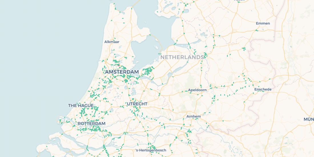
US Broadband Map: Closing the Digital Divide in America
The Connect America Fund aims to close the digital divide between rural & urban America. Learn more about it's impact with a newly updated map from the USAC.

Healthcare Analytics: How Boston uses Location Intelligence
Discover how Vital Village Network & Boston Medical Center use Location Intelligence & Open Data to promote family & community safety within Boston

CARTO at Snowflake Summit 2021
Register now to see our talk at Snowflake Summit 2021 with Indigo Ag on how spatial data flows out of Snowflake into map-centric apps.

OGC appoints Javier de la Torre to its Board of Directors
We are very pleased to announce the appointment of Javier de la Torre, Founder & CPO of CARTO, to The Open Geospatial Consortium's (OGC) Board of Directors

Using Route Optimization & IoT Data in Waste Management
The pandemic has significantly affected waste management in our cities - read how Location Intelligence can be used to optimize collection & reduce costs.

6 Companies using Location Intelligence for Sustainability
How can Location Intelligence be used for Sustainability? Discover some examples including sustainability for agriculture, environment, mobility, cities, & more

Aena's Indoor Mapping & Routing App Expands to Barcelona
AenaMaps, a solution developed by CARTO, Telefónica, & Situm, leveraging indoor mapping to provide navigation within Aena's airports expands to Barcelona

Retail Site Selection: Complimentary Post Pandemic Playbook
Download our new report on site selection strategies & how location data & advanced spatial analysis can help retailers adapt & thrive in a post pandemic world

Agricultural Sustainability with CARTO, Indigo Ag, & Snowflake
With our platform & Snowflake connector, read how Indigo Ag rapidly gathers, styles, & shares insights from spatial models improving agricultural sustainability

COVID Vaccine: Mapping Rollout & Optimizing Supply Chain
As COVID vaccines become more widely available we look maps analyzing the rollout & supply chain optimization for an efficient & equitable immunization strategy

Human Mobility & Transport Analysis in the Canary Islands
Optimizing transport infrastructure spatially is key to the future of mobility - see how CARTO, Vodafone, & SAGULPA built a platform for the city of Las Palmas

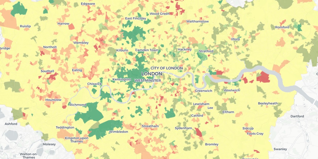
Analyzing UK Covid Recovery & Mobility with Avison Young
Explore Avison Young's UK Cities Recovery Index, monitoring commercial real estate rebound post-pandemic, analyzing diverse sectors, and predicting recovery trajectories.

Using Data & Maps to Analyze England's Response to COVID-19
As cases of Coronavirus rebound, having an effective Test & Trace system in place is crucial. A new dashboard with maps evaluates the NHS response in England.

Modern Distribution Management Transformation in CPG
Modern Distribution Management, encompassing supply chain network design & logistics optimization, is going through a transformation. See why spatial is key.

Announcing the Spatial Data Scientist of the Year 2020
As #SDSC20 draws to a close today, we reflect on the conference & announce the first winner of the Spatial Data Scientist of the Year Award!

Today Thousands of Spatial Leaders Gather for #SDSC20
#SDSC20 Online starts today! Join thousands of spatial leaders from around the world over 5 days to discuss & learn about the future of Spatial Data Science.

Indoor Mapping & Airport Routing launched by Aena & Telefonica
Aena, in collaboration with CARTO, Telefónica, & Situm has launched 'AenaMaps', a solution leveraging indoor mapping to provide navigation within its airports.

Data Monetization: A Complimentary Guide for Enterprise
Download our data monetization guide on how to transform big data into a viable product. See how leading enterprise CDO / CTOs from Vodafone & Mastercard do it.

How to Analyze & Visualize Spatial Data in Databricks
Explore examples of Databricks & CARTO together as part of a collaborative Data Science process including visualizing Big Data sets & creating ETL pipelines.

What is Fleet Management & Best Spatial Practices
What is Fleet Management & how can Location Intelligence be used to improve efficiency, reduce costs, & provide compliance? We explore.

Using Location Intelligence to Combat Litter with PMI
In partnership with Philip Morris International, Litterati, & Cortexia, read how Spatial Data is being used to combat litter beginning with Lisbon, Portugal.

Map of the Month: Coffee Supply Chain Traceability
For our Map of the Month read how Enveritas use CARTO to analyze the traceability & sustainability of coffee supply chains around the world.

Fintech Spatial Data Science Masterclass with J.P.Morgan
Read a summary of the DeepFin (where Fintech meets Deeptech) Investor Masterclass we recently held with J.P.Morgan, a leading global financial services firm.
Raster vs Vector Maps: What's the Difference & Which are Best?
A look at the key differences of raster vs vector maps for geospatial data visualization, advantages & disadvantages of each, & which are the best.

Using Location Intelligence to return to Valencian beaches
Play&go with the collaboration of dotGIS develops an app using CARTO's platform to ensure health & safety on the beaches of Valencia, Spain.

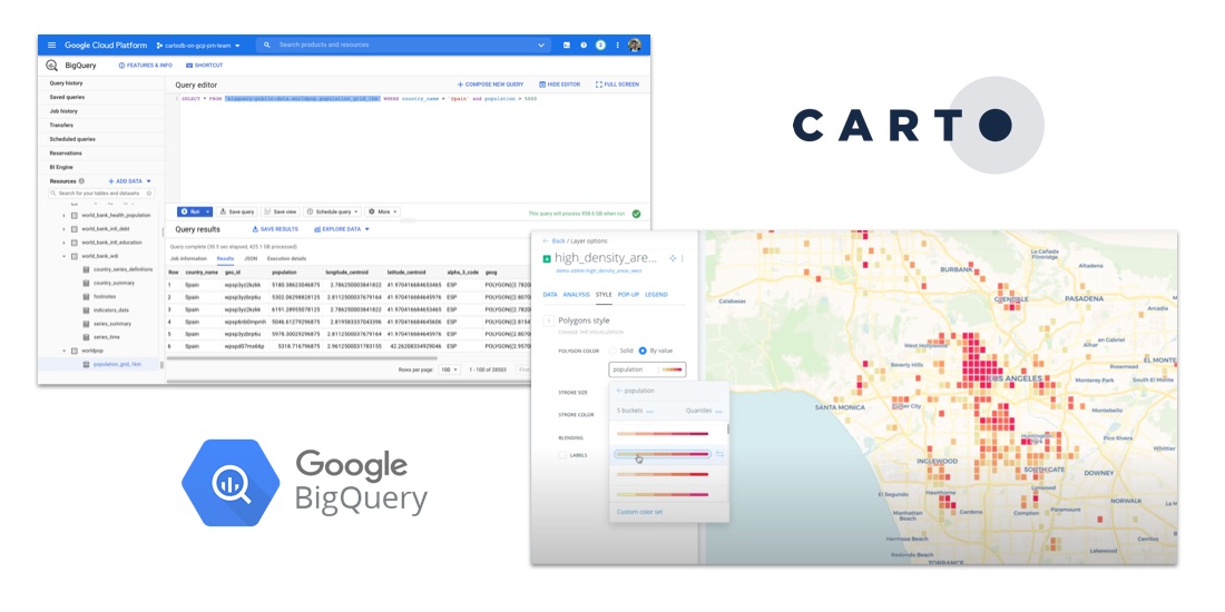
Building COVID-19 Dashboards with Google BigQuery
See how private & public sector organizations use Google Cloud Platform with CARTO to share insights & map visualizations relating to the coronavirus pandemic.

Comparative Market Analysis Real Estate: Twin Areas
With many retailers consolidating stores & focusing on curbside pickup, comparative market analysis real estate can identify twin areas to maximize revenue.

COVID-19 Inequality: A Focus on Brazil Coronavirus Maps
With Brazil Coronavirus cases soaring we take a look at the importance of using maps as an awareness tool to ensure an appropriate response.

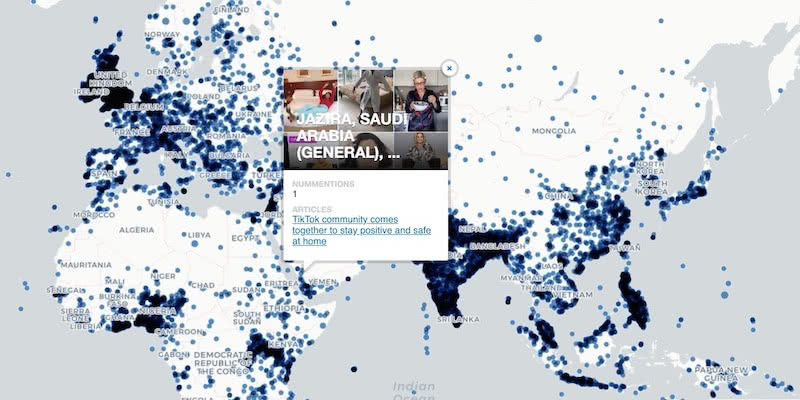
US Protest Map & Visualizing Police Violence
Using Spatial Analysis to analyze & visualize Location Data relating to the recent protests & police violence in the US including a protest map.

City Pedestrianization & Micromobility Post COVID-19
To enable safe social distancing cities are pedestrianizing urban areas & building infrastructure for greener transportation & micromobility. Discover how location data can help.

HIPAA Compliance in Geospatial Healthcare Analytics
Read how HIPAA compliance is maintained across the CARTO platform & about key use cases for customers working in the healthcare space.

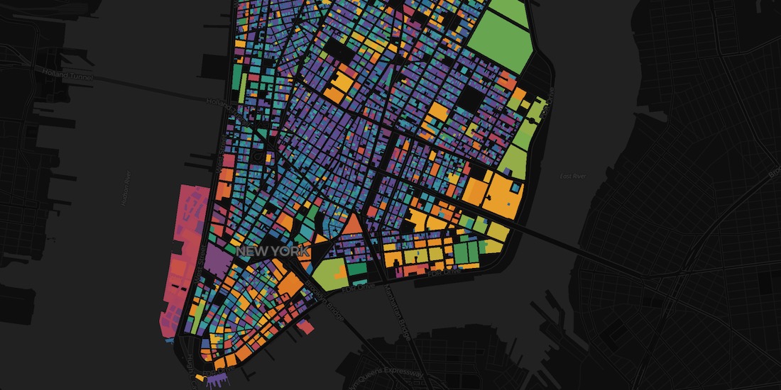
London vs New York: Which city has the higher average building height?
The City vs Wall Street. Piccadilly Circus vs Times Square. The answer will surprise you as we discover through maps & visualization.
Using Spatial Data in Retail Analytics Post COVID-19
A look at how spatial analysis & new data streams such as telco & credit card data can provide insights in a return to retail post COVID-19.

Acquiring New Customers with Geomarketing for Online Retailers
Learn more about Geometric, a Geomarketing solution for Online Retailers made by Anagraph & their work creating COVID-19 dashboards for Canada.
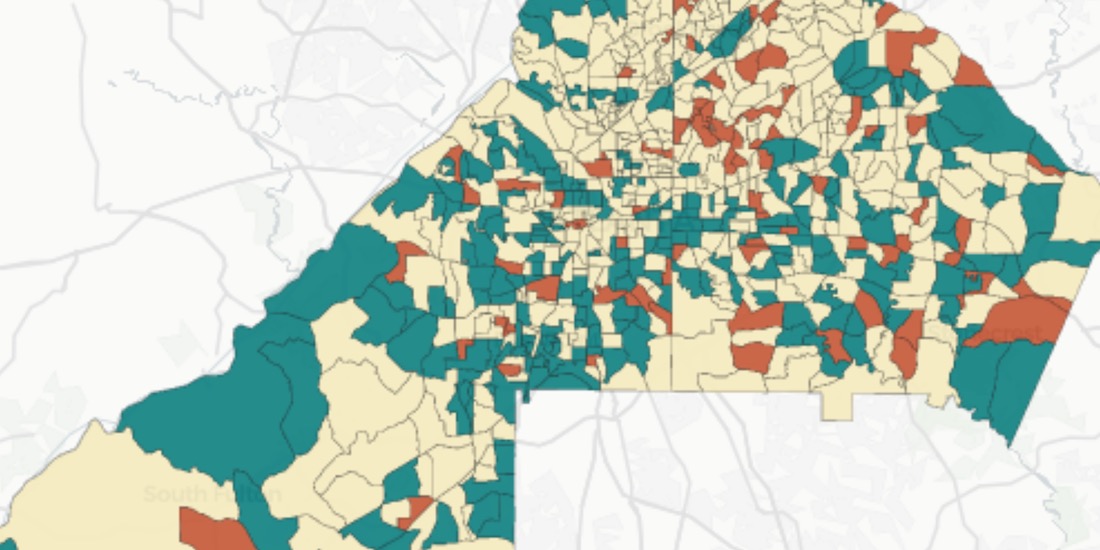
Assessing Potential Impact of COVID-19 on Rural Communities
Read how the Center on Rural Innovation & others used CARTO to determine which rural communities in the US are in need of greater support against COVID-19.

OOH Bounce Back: 2020 Predictions
A look at the impact of COVID-19 on OOH & how geospatial solutions can be used in the post pandemic recovery of the industry.

CARTO & Fulcrum partner to provide COVID-19 emergency response solutions
Leaders in data collection & spatial analysis come together to enable organizations to overcome the coronavirus through grants program.

AsistenciaCOVID-19 Available in Five New Regions of Spain
AsistenciaCOVID-19, the self diagnosis app which CARTO is collaborating on, is now available in five new regions of Spain.

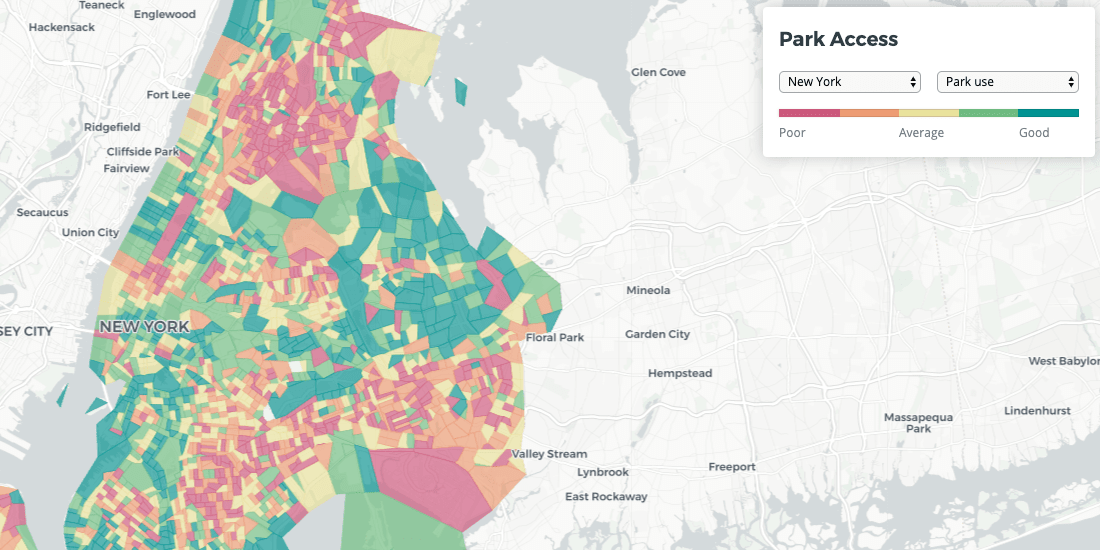
Analyzing Food Access in NYC During COVID-19
We explore how Territorial Empathy are using spatial analysis to visualize food access across NYC during the pandemic.

Mobilizing Volunteers to Help the Most Vulnerable through Maps
#StudentsAgainstCorona is a platform supported by our grants program enabling the pairing of volunteers with the elderly & vulnerable individuals who need support through the Coronavirus lockdown.

CARTO Provides Free Visualization Software for Organizations Fighting COVID-19
The CARTO Grants for Good program gives organizations fighting COVID-19 access to our platform for mapping & visualization of the outbreak

Mapping Coronavirus Impact on Events & Conferences
A look at the effect that Coronavirus (COVID-19) is having on tech events and conferences around the world

Map of the Month: Bringing Smallholder Coffee Farmers out of Poverty
Enveritas leverages Location Intelligence to visualize global coffee production and poverty levels among farmers, as they work towards a more sustainable global coffee industry

.png)