Posts by
Florence Broderick


CARTO Brings Cloud-Native Location Intelligence to G-Cloud
CARTO's cloud-native Location Intelligence platform is now available as a G-Cloud Supplier in the Crown Commercial Services Digital Marketplace.

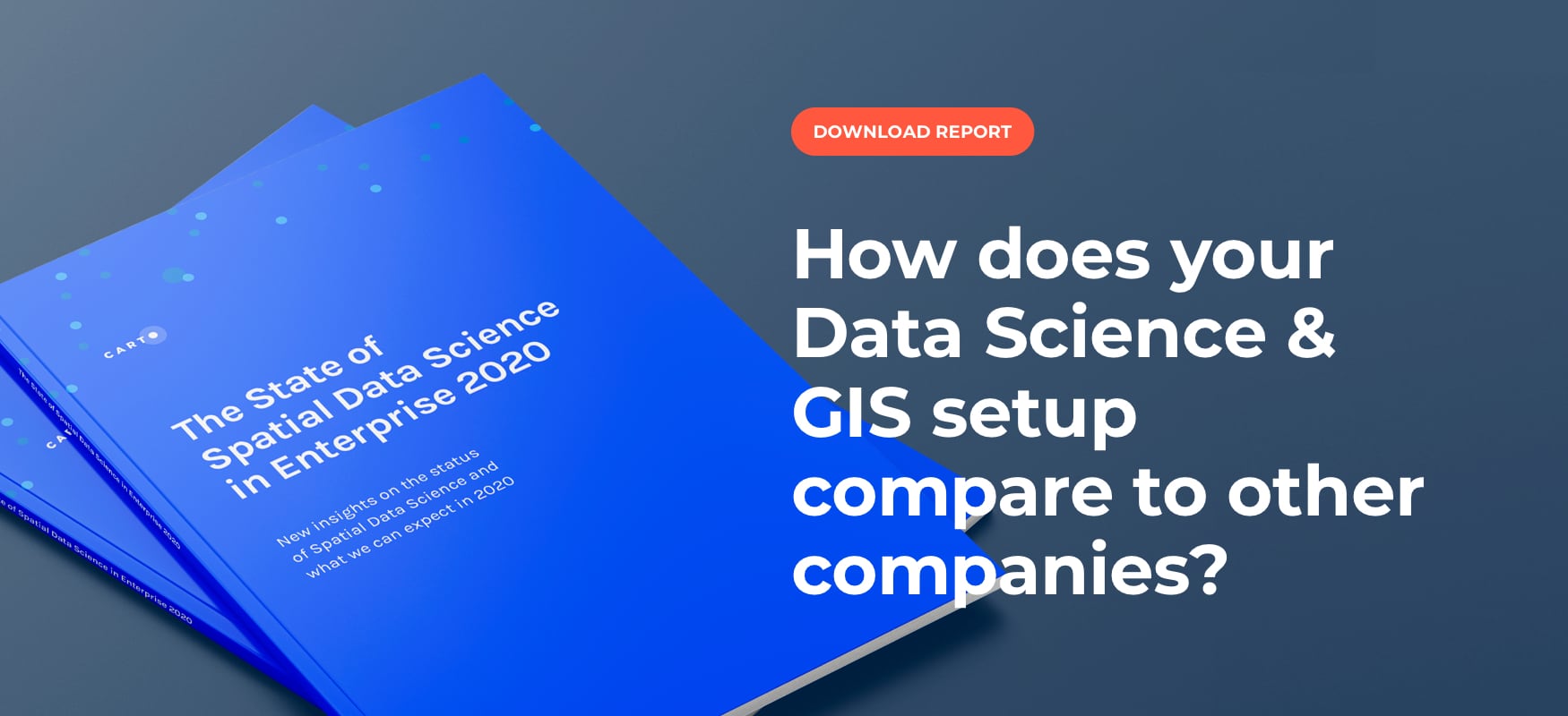
Spatial Data Scientist of the Year Award 2022
At #SDSC22 the first winner of the Spatial Data Scientist of the Year award will be announced. Submit your nomination today!

CARTO presenting at GEO Business 2021, UK’s largest geospatial event
We’re excited to announce that we’ll be attending & presenting at GEO Business 2021, the UK’s largest geospatial event, taking place on November 24 - 25 at ExCeL London.

PMI, Litterati, & Clear Channel Win Geospatial Excellence Awards
We’re very pleased to announce that at this year’s Geospatial World Forum, CARTO clients Philip Morris International, Litterati & Clear Channel have all won awards.

CARTO & Havas Media Group present at Big Data & AI World Madrid 2021
We’re excited to announce that we’ll be presenting alongside Havas Media at this year’s Big Data & AI World 2021 (part of the Madrid Tech Show).

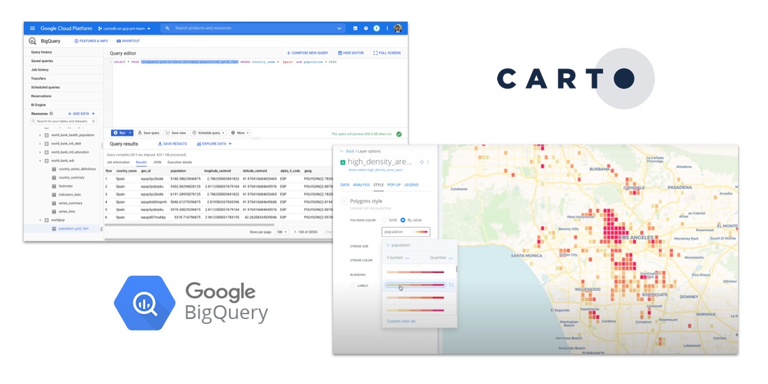
CARTO & Google Cloud announce sustainability partnership to fight Climate Change
CARTO & Google Cloud announce a sustainability partnership to enable organizations to better understand climate change through massive geospatial datasets.

Spatial Data Science Conference '21: More Speakers Confirmed
The Spatial Data Science Conference 2021 brings together leaders from industry, government, & academia for four days of talks on the latest technologies & techniques.

Spatial Data Science Conference '21: First Speakers Announced
With the 5th annual Spatial Data Science Conference just over a month away we’re very excited to announce the first lineup of speakers. Register for free today!

CARTO announced as a Google Cloud Edge partner for Communications Service Providers
As part of Google Cloud’s initiative to bring partner solutions to the network edge, we’re delighted to announce CARTO has been listed as a strategic partner.

Real Estate Analytics: The Work from Home (WFH) Effect
The increase in WFH due to the pandemic is causing changes in many industries, not least real estate–see how spatial analysis can identify new demand

#SDSC21: Financial Services Summit Agenda Now Available
Sign up for talks from JPMorgan, Goldman Sachs, Bloomberg, Swiss Re, Signal Capital, Willis Towers Watson, Jefferies, PicPay, Cifas, BBVA, Google, & Safegraph

Announcing #SDSC21: A Series of Spatial Data Science Events
Following the success of #SDSC20 we're excited to announce 2021's online edition of the Spatial Data Science Conference plus 2 more industry specific events

7 Reasons Why CPG Marketers Are Turning To Location Analytics
Discover how CPG/FMCG marketers & CMOs can use geospatial analysis & data to evolve their analytics to rapid consumer changes in the new normal

Spatial Data Scientist of the Year Award
At #SDSC20 the first winner of the Spatial Data Scientist of the Year award will be announced. Submit your nomination today!

#SDSC20 Speakers & Full Agenda Now Available
The Spatial Data Science Conference 2020 brings together leaders from industry, government, & academia for five days of talks on the latest technologies & techniques.

Announcing CARTO & Thinking Machines partnership
We are excited to announce that Thinking Machines a Data Science consulting firm specializing in geospatial, are now CARTO partners.

MBI's global spatial data available in CARTO's Data Observatory
Michael Bauer International's wide range of spatial data is available through CARTO's Data Observatory to provide socio demographic insights & digital boundaries.

Announcing #SDSC20 Online: Spatial Data Science On Demand
Join us this October for #SDSC20, a free virtual conference featuring expert speakers & panelists sharing details of their work in Spatial Data Science.

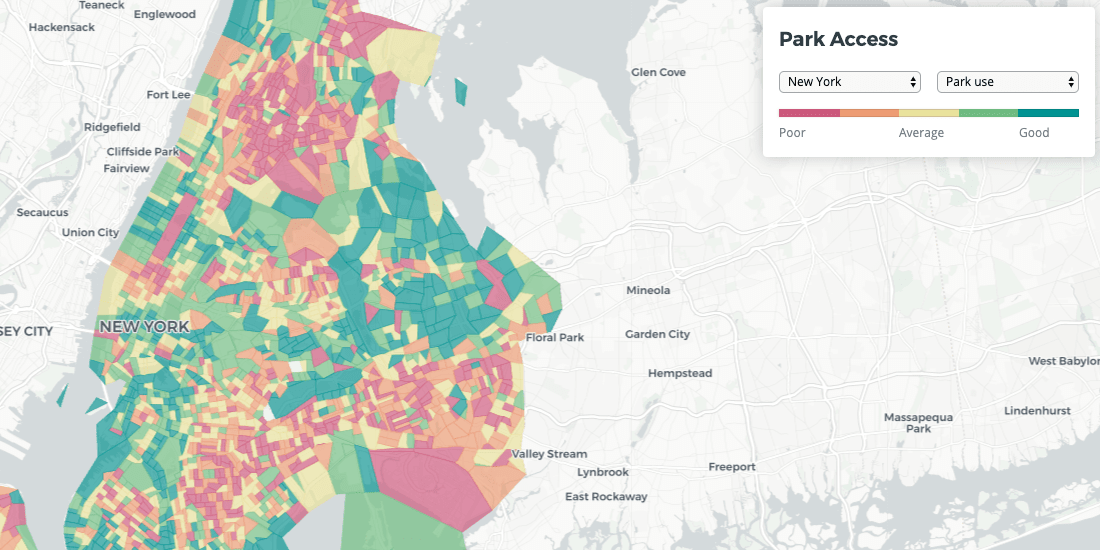
Identifying Walk to Work Hotspots in London
We explore Howsy's research on walk to work rental hotspots across London, with consumers looking to ditch mass transit as they look to change their new normal commute.

GIS Indoor Mapping: Workplace Social Distancing
We explore how GIS Indoor Mapping Software can help organizations on their return to work, ensuring best practice in social distancing & contact tracing.

Location Analytics: A Roadmap to Post COVID-19
Everyone has the same question: when will we return to normal? Spatial analysis has helped immensely to contain the spread, now how will it help us recover?

Online Grocery Shopping - Route Optimization & Spatial Analysis during COVID19
How can online grocery shopping businesses use spatial analysis & route optimization to optimize through panic-buying? We explore real-life examples.

CARTO collaborates on 'AsistenciaCovid19' App against Coronavirus
CARTO work alongside ForceManager, Mendesaltaren, Telefonica, Google, Ferrovial & others to slow down the spread of COVID-19

Spatial Analysis: Private Equity's Secret Weapon
Which types of funds invest in spatial analysis? How do they use location data in screening & portfolio management? We discuss the role of Data Science.

CARTO joins The Urban Computing Foundation Technical Advisory Committee
Today we are very excited to announce that CARTO's Javier de la Torre, our Founder and Chief Strategy Officer, is joining the Urban Computing Foundation (UCF) Technical Advisory Committee

Solving Global Litter with Machine Learning & Spatial Data
Learn how Litterati is leveraging Location Intelligence and Spatial Data Science in the fight against global litter


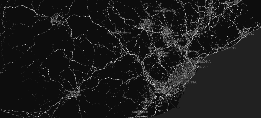
Introducing CARTO Traffico: A Crowdsourced GPS Data Traffic Management Solution
CARTO Traffico is a traffic management solution for civic engineers and urban planners that integrates crowdsourced GPS data with city specific mobility data sources to help cities adapt to citizens’ changing transportation behavior

Survivalists & Selectionists: How CPGs Understand Demographic Divides Through Location
Understanding modern demographic divides will help CPGs to adapt and thrive in changing consumer environments

Mapping the Impact of Madrid's Line 5 Shutdown
Find out how Location Intelligence help local officials measure impact transit closures will have upon cities in our latest post.

CARTO 2018: Our Year In Review
From start of year roadmaps to end of year industry recognition, here’s a brief recap of our very busy 2018!
.png)