CARTO + Placekey: Cloud Native Spatial Linkability


In the world of Spatial Data Science being able to accurately and consistently link data to physical location points on a map is crucial. However place data is often messy inconsistent or ambiguous making it challenging to aggregate and match.
Introducing Placekey
In response to these issues Placekey was created: a free universal standard identifier for any physical place. Placekey combines the ‘where’ (the geospatial point on a map) with the ‘what’ (what the location actually is i.e. a Starbucks) creating a comprehensive and unique identifier to pinpoint places not spaces. For example two different restaurants may share the exact same address because they are located in the same mall. Placekey is smart enough to know that these are different places despite their identical addresses and will create unique placekeys for each.

CARTO recently had the pleasure of participating in the Placekey launch as a founding member. There we were able to take a deep dive into the Placekey offering and demonstrate how users can link and enrich their placekeys with data insights in the cloud using CARTO's Data Observatory and CARTOframes.
To learn about our session at the launch and how CARTO and Placekey will work together read more below.
Placekey in CARTO’s Data Observatory
After users have created universal identifiers for their location points using Placekey they'll likely want to take their analysis a step further and enrich their place data with spatial features available in other types of datasets so as to make better spatially-aware decisions. Enter: the CARTO Data Observatory.
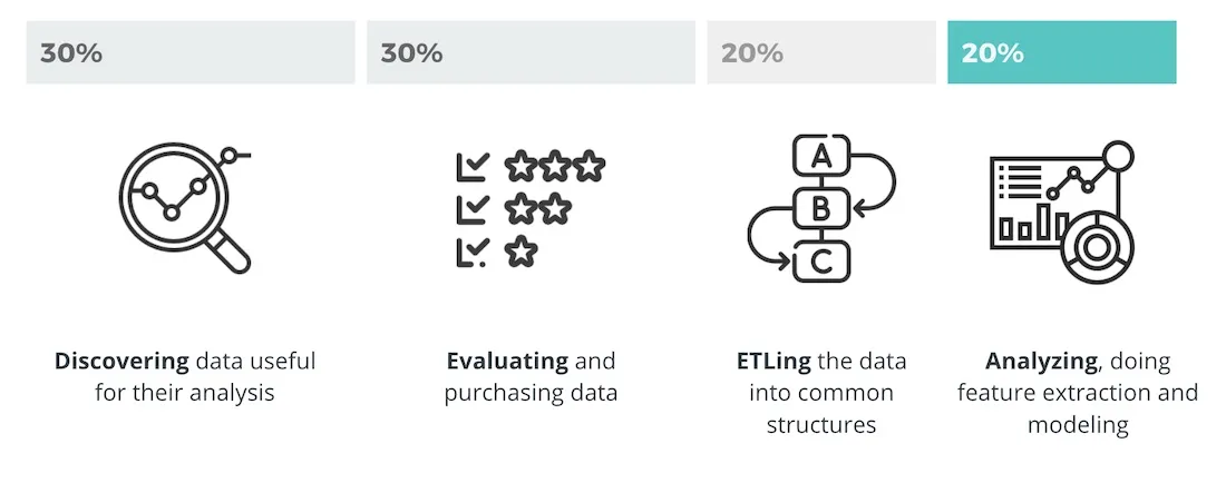
CARTO’s Data Observatory provides access to an extensive catalog of spatial datasets to solve some of the most common struggles that users encounter in their spatial analyses. We've found that companies waste almost 80% of their time on things like data discovery evaluation and ETLing alone. And wasted time equals wasted money. With the Data Observatory they can bypass this painstaking and expensive process and easily access pre-vetted and unified data sources so they can spend time on what really matters: analysis.
With Placekey enabled as a standard feature in the datasets available via the Data Observatory users can easily make enrichments and link geospatial data from multiple sources to their placekeys. With CARTO's cloud native Location Intelligence platform brands can not only enrich and link placekeys to data within the Data Observatory but they can do it all within their preferred cloud environment .
So what does this all look like?
As we showcased in the Placekey launch event CARTO has made placekeys available within CARTOframes allowing users to enrich data with any spatial dataset from the Data Observatory.
This public Google Colab notebook illustrates how to enrich store data with demographics and human mobility features. Using our enrichment methods in CARTOframes all you need is the associated placekey to get started.
We’ve also enabled functions so that users can create placekeys directly in BigQuery before enriching their data.
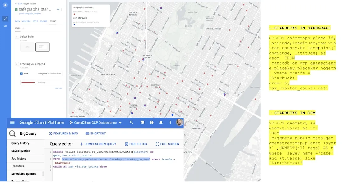
Let's say Starbucks is trying to visualize and analyze their store locations in NYC. They are using two data sources to identify their locations: Safegraph and Open Street Maps. Both sources have different place data formatting that makes it difficult to combine the locations into one comprehensive list of geospatial points.
Sounds challenging right? Well Starbucks is in luck. Using Placekey they can safely combine the two data sources to create unified points on the map.
Now that they’ve created consistent placekeys for their location points they want to link them with data to analyze their store locations. Using relevant datasets from the Data Observatory such as demographics human mobility and consumer behavior Starbucks can easily link and enrich their placekeys directly in CARTOframes. This helps them visualize trends and understand consumer behavior in proximity to their store locations which ultimately helps them make important decisions about their business.
What's next?
In the coming months CARTO is excited to continue building a seamless integration of Placekey within the different components of our technology stack as well as natively on every leading cloud platform. In addition we’ll collaborate with our data partners to ensure that all datasets available via the Data Observatory are Placekey-enabled to ensure easy multi-source linkability and data enrichment.
Looking further into the future we envision that users will only need to provide placekeys in order to visualize data on maps making the process simple and efficient. We also have plans to make Placekey a key component of spatial modelling thanks to its universal nature.
Want to see this in action?
Request a live personalized demo
 | This project has received funding from the European Union's Horizon 2020 research and innovation programme under grant agreement No 960401. |