How to Use Location Intelligence for Civic and Social Good


The number of charitable organizations around the world increases every year. There are more than 1.5 million nonprofit organizations registered in the United States alone according to the National Center for Charitable Statistics. These organizations are committed to helping communities by providing charitable resources like sending relief aid conducting research or creating educational programs.
In order to better distribute precious resources NGO’s often collect data related to their efforts. However it’s also common for nonprofits to lack the bandwidth or knowledge to analyze the data they collect. With the use of Location Intelligence tools like CARTO companies can help to improve impact and operations for these types of organizations. One company that is committed to this effort is Azavea a geospatial software development firm based in Philadelphia.
Azavea utilizes CARTO to complete a wide range of projects for clients in the nonprofit and public sector. Azavea’s mission is to apply geospatial technology for positive civic social and environmental impact while advancing the field through research.
How can you use location intelligence to help communities?
Visualize Green Initiatives in Your City
Azavea used CARTO to build projects that support the implementation and documentation of “Greenworks ” Philadelphia’s comprehensive sustainability plan initiated by the Mayor’s Office of Sustainability. The Building Energy Benchmarking interactive web application displays two years of Energy Benchmarking results for large facilities in Philadelphia. The [Greenworks map] is an interactive visualization of Greenworks Projects completed by the City of Philadelphia and its partners from 2009 to 2015. Using the CARTO database and web map tile server infrastructure enabled Azavea to complete these projects efficiently.
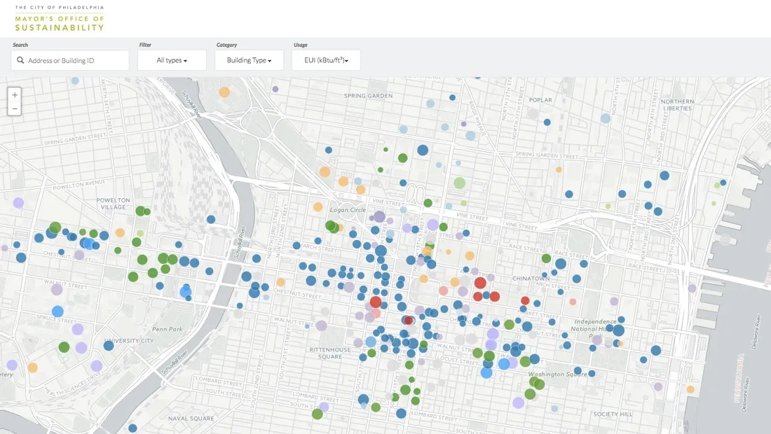
Azavea built the Building Energy Benchmarking interactive web application for the Philadelphia Mayor’s Office of Sustainability using CARTO as the backend
Show the Effects of Legislation
The Azavea Data Analytics team recently completed a map for [WHYY Keystone Crossroads] that allows users to visualize how each of Pennsylvania's 500 school districts would be affected if lawmakers chose to implement the Commonwealth’s new funding formula more rapidly. The team stored the data in CARTO and used the cartodb.createVis method through the CARTO API to pull in the visualization. The team designed with similar styles to CARTO widgets and set the map to re-style based on user input.
Help Nonprofits Accomplish Their Mission
In addition to using CARTO for client work Azavea uses the platform as part of charitable projects.
Summer of Maps fellows often use CARTO to develop custom interactive web maps for nonprofits. Summer of Maps is a fellowship program that matches nonprofit organizations that have spatial analysis needs with talented students pursuing careers in geospatial data analysis to complete projects over a three-month period during the summer.
During the summer of 2016 an Azavea Summer of Maps fellow worked with Transportation Alternatives to engage the public in exploring connections between traffic crashes and poverty in NYC. The fellow developed an interactive web application built on CARTO and D3 that integrates geospatial and statistical views of the data. Other projects that have used CARTO include:
- An interactive application displaying air pollution that visualizes nationwide air quality developed for the Chemical Heritage Foundation
- An interactive web map of major injury and fatal crashes from 2010 to 2015 displayed with Indicators of Potential Disadvantage by census tract
- A torque map showing the growth of the Philadelphia LandCare Program over a 15 year period
Why CARTO?
The Azavea team chooses CARTO for projects because it provides a scalable PostgreSQL database for small datasets that can pull data via a REST API. Azavea developers can also create display and tweak visualizations based on client data via Leaflet maps on the websites they build.
Know a Nonprofit that Needs Geospatial Data Analysis?
The Azavea Summer of Maps program is now accepting project proposals from nonprofit organizations. The nonprofit applications are open until Feb. 5th 2017.Nonprofits that can benefit from geospatial data analysis location intelligence and mapping services should visit the Summer of Maps website to apply.
Read more about the impact of the Summer of Maps program or watch this video to learn more about Summer of Maps.
Student GIS fellowship applications will open in February 2017.
Visit Azavea.com for more information about their products and services centered on having a positive civic and social impact including predictive policing software urban forest management tools and a high-performance geographic data processing engine.
If you are an NGO or not for profit organization interested in partnering with CARTO or utilizing location intelligence for civic and social good please apply for a Grants for Good.
This is a guest post from our valued Partner Azavea.
Happy Data Mapping!