-
Fundamentals
-
Docs
Libraries
API
Mobile SDK allows you to create mobile apps over the CARTO platform.
This component is still under support but it will not be further developed. We don’t recommend starting new projects with it.
Mobile SDK allows you to create mobile apps over the CARTO platform.
This component is still under support but it will not be further developed. We don’t recommend starting new projects with it.
Maps in CARTO Mobile SDK are organized overlaying layers. Layer displays map and takes data from a connected DataSource, which has data loading and processing logics.
Depending on data type you can use following layer types:
An online map app configuration could be composed from following classes and elements:
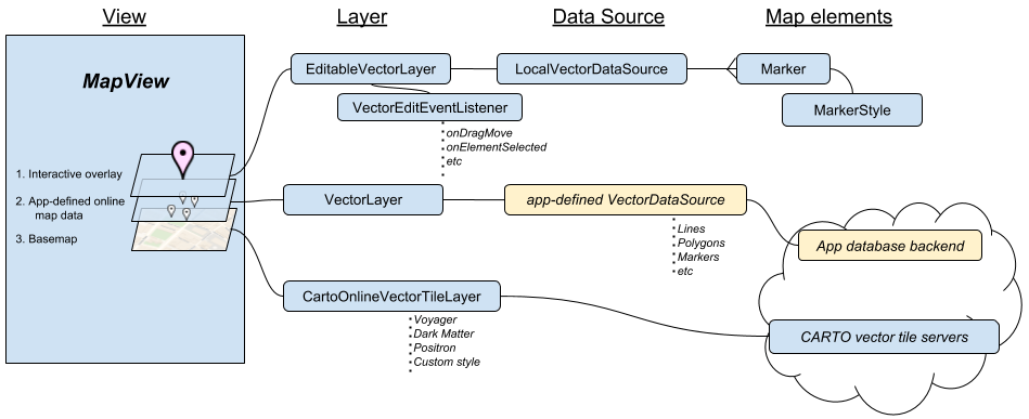
Here are:
Every app is different, and in your app you may need different combination of Layers and Data Sources, and SDK provides you many of them. Data Sources can be implemented by app, if built-in ones are not enough, or if you need to support your specific server API or file format. Layers and vector objects are fixed; and there is very rarely any need to change these.
The layers are added from bottom to top order.
This adds to map CARTO built-in vector tile service with generic streetmaps, you just set styling and all the rest is done automatically.
1
2
3
4
5

     CartoOnlineVectorTileLayer layer = new CartoOnlineVectorTileLayer(CartoBaseMapStyle.CARTO_BASEMAP_STYLE_POSITRON);
     mapView.getLayers().add(layer);
1
2
3
4
5

     var layer = new CartoOnlineVectorTileLayer(CartoBaseMapStyle.CartoBasemapStylePositron);
     MapView.Layers.Add(layer);
1
2
3
4
5

     NTCartoOnlineVectorTileLayer* layer = [[NTCartoOnlineVectorTileLayer alloc] initWithStyle:NT_CARTO_BASEMAP_STYLE_POSITRON];
     [[self.mapView getLayers] add:layer];
1
2
3
4
     let layer = NTCartoOnlineVectorTileLayer(style: NTCartoBaseMapStyle.CARTO_BASEMAP_STYLE_POSITRON)
     mapView?.getLayers()?.add(layer)
1
2
3
4
     val layer = CartoOnlineVectorTileLayer(CartoBaseMapStyle.CARTO_BASEMAP_STYLE_POSITRON)
     mapView?.layers?.add(layer)
For certain maps - especially for Satellite imagery (sourced from HERE) CARTO provides ready-made online raster maps layer. Following ID-s can be used as “source” parameter in CartoOnlineRasterTileLayer:
1
2
3
4
  CartoOnlineVectorTileLayer layer = new CartoOnlineRasterTileLayer("here.satellite.day");
  mapView.getLayers().add(layer);
1
2
3
4
  var layer = new CartoOnlineRasterTileLayer("here.satellite.day");
  MapView.Layers.Add(layer);
1
2
3
4
  NTCartoOnlineVectorTileLayer* layer = [[NTCartoOnlineRasterTileLayer alloc] initWithSource:@"here.satellite.day"];
  [[self.mapView getLayers] add:layer];
1
2
3
4
  let layer = NTCartoOnlineRasterTileLayer(source: "here.satellite.day")
  mapView?.getLayers()?.add(layer)
1
2
3
4
  val layer = CartoOnlineRasterTileLayer("here.satellite.day")
  mapView?.layers?.add(layer)
Your app can define own DataSources for custom needs, e.g. implement loading from own API, process/edit data on the fly etc. This can be done in app level and in whatever language you use, without touching SDK code. Custom DataSource should extend one of following abstract base classes:
Some DataSources are more generic and can be used for different data types and map layers (vector or raster). Others can only be applied for specific layer types.
Data Sources can deal with map tiles, or with individual vector objects. Here are the key tile-based datasources:
MBTilesTileDataSource loads data as tiles from MBTiles file on device. The tiles can be raster tiles or vector tiles (Mapbox Vector Tiles). Your app has to know where is the MBTIles and has to take care logistics of the file.
HTTPTileDataSource loads online tiles using HTTP. It does not care whether the content is raster of vector tile, but you need to know it, and use it with either RasterTileLayer or VectorTileLayer.
PersistentCacheTileDataSource is a ‘virtual’ data source in a sense that it does not provide data itself, but takes data from another specified datasource, caches it in file system with given parameters, and outputs it. So if already cached tile is requested, then it is loaded from the cache, not original source. It works with tiled data sources, and is typically used with HTTPTileDataSource to cache persistently online tiles.
As example following code loads online raster tiles into your map view. You can use any common web tiles in PNG or JPG formats, in Spherical Mercator system, just define proper ZXY or Quad-tree-based URL pattern for tiles.
Tip: For general information about raster tiles and geospatial data, see the following Open Source Geospatial Foundation reference materials for Tile Map Service and Featured Tile Layers.
The following tags are supported in the URL definition: zoom, x, y, xflipped, yflipped, quadkey.
1
2
3
4
5
6
7
    String url = "http://ecn.t3.tiles.virtualearth.net/tiles/a{quadkey}.jpeg?g=471&mkt=en-US";
    TileDataSource baseRasterTileDataSource = new HTTPTileDataSource(1, 19, url);

    TileLayer baseLayer = new RasterTileLayer(baseRasterTileDataSource);
    mapView.getLayers().add(baseLayer);
1
2
3
4
5
6
7
    string url = "http://ecn.t3.tiles.virtualearth.net/tiles/a{quadkey}.jpeg?g=471&mkt=en-US";
    var baseRasterTileDataSource = new HTTPTileDataSource(1, 19, url);

    var baseLayer = new RasterTileLayer(baseRasterTileDataSource);
    MapView.Layers.Add(baseLayer);
1
2
3
4
5
6
7
    NSString* url = @"http://ecn.t3.tiles.virtualearth.net/tiles/a{quadkey}.jpeg?g=471&mkt=en-US";
    NTHTTPTileDataSource* baseRasterTileDataSource = [[NTHTTPTileDataSource alloc] initWithMinZoom:1 maxZoom:19 baseURL:url];

    NTRasterTileLayer* baseLayer = [[NTRasterTileLayer alloc] initWithDataSource:baseRasterTileDataSource];
    [[mapView getLayers] add:baseLayer];
1
2
3
4
5
6
7
    let url = "http://ecn.t3.tiles.virtualearth.net/tiles/a{quadkey}.jpeg?g=471&mkt=en-US"
    let baseRasterTileDataSource = NTHTTPTileDataSource(minZoom: 1, maxZoom: 19, baseURL: url)

    let baseLayer = NTRasterTileLayer(dataSource: baseRasterTileDataSource)
    mapView?.getLayers()?.add(baseLayer)
1
2
3
4
5
6
7
    val url = "http://ecn.t3.tiles.virtualearth.net/tiles/a{quadkey}.jpeg?g=471&mkt=en-US"
    val baseRasterTileDataSource = HTTPTileDataSource(1, 19, url)

    val baseLayer = RasterTileLayer(baseRasterTileDataSource)
    mapView?.layers?.add(baseLayer)