


Nagarro & CARTO: Advancing Enterprise AI Transformation
CARTO and Nagarro partner to help enterprises move AI from pilots to production, embedding Location Intelligence into existing workflows and systems.


7 Reasons Why CPG Marketers Are Turning To Location Analytics
Discover how CPG/FMCG marketers & CMOs can use geospatial analysis & data to evolve their analytics to rapid consumer changes in the new normal


Short Term Rental Data from Transparent now available in CARTO
We are pleased to announce our partnership with Transparent, a leader in short-term rental intelligence, & the inclusion of their data in our Data Observatory

React to the Changing Face of Retail DIY with Behavioral Data
With COVID-19 causing dramatic shifts in consumer spending behavior, DIY & other retailers can leverage geospatial data to discover new revenue opportunities.


Using Data & Maps to Analyze England's Response to COVID-19
As cases of Coronavirus rebound, having an effective Test & Trace system in place is crucial. A new dashboard with maps evaluates the NHS response in England.

CARTO BigQuery Tiler Upgrade Gives Speed & Feature Boost
Read about new features to CARTO BigQuery Tiler: the fastest, most convenient, & cost effective way to visualize spatial Big Data & generate Tilesets for the web

Modern Distribution Management Transformation in CPG
Modern Distribution Management, encompassing supply chain network design & logistics optimization, is going through a transformation. See why spatial is key.

Announcing the Spatial Data Scientist of the Year 2020
As #SDSC20 draws to a close today, we reflect on the conference & announce the first winner of the Spatial Data Scientist of the Year Award!


Spatial Features, the new derived dataset from CARTO
We are excited to announce the release of our first derivative data product providing global demographic data & POI aggregations by category.

Today Thousands of Spatial Leaders Gather for #SDSC20
#SDSC20 Online starts today! Join thousands of spatial leaders from around the world over 5 days to discuss & learn about the future of Spatial Data Science.
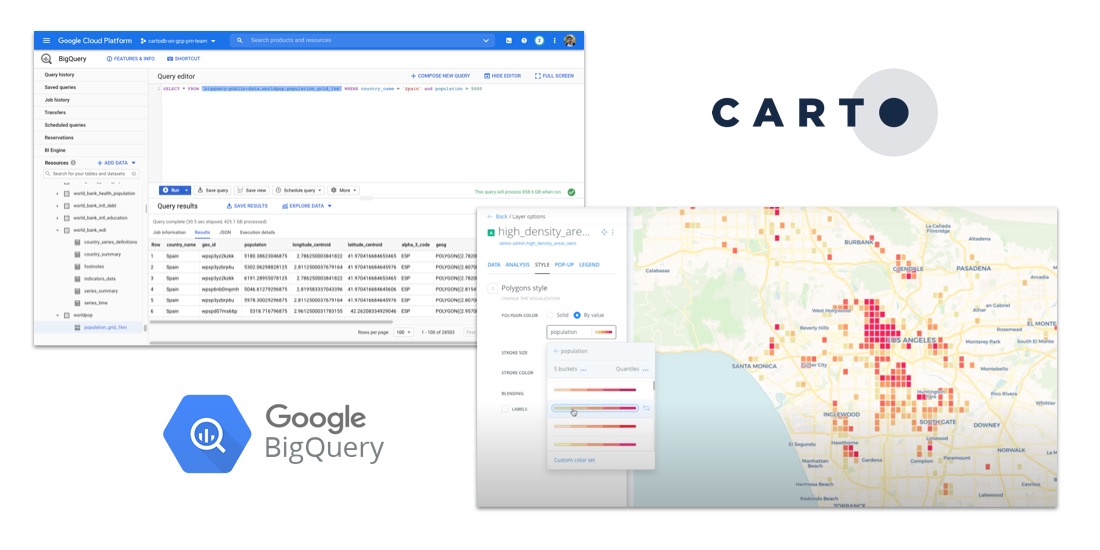
How to Analyze Google BigQuery Data in CARTO
Learn how to visualize geospatial Big Data hosted in Google BigQuery by creating a CARTO instance on the Google Cloud Platform & using our BigQuery Connector.


CARTO for deck.gl: The Best Way to Develop Spatial Apps
CARTO is now available as part of the deck.gl framework & becomes our preferred & recommended library for building spatial applications

CARTO + Placekey: Cloud Native Spatial Linkability
Learn more about our integration with Placekey, enabling universal standard identifiers for any physical place to be used with spatial analysis & visualization.

Academy
Nagarro & CARTO: Advancing Enterprise AI Transformation
CARTO and Nagarro partner to help enterprises move AI from pilots to production, embedding Location Intelligence into existing workflows and systems.


Unlock trade-area analysis at scale with H3 Isochrones
Scale travel-time analysis with H3-based isochrones in CARTO. Faster joins, overlap insights, and 96–99% time savings powered by TravelTime.

Geospatial Foundation Models: Workshop Takeaways
Explore the state of geospatial foundation models, from representation learning to population dynamics, with insights from the CARTO & BSC workshop.

.jpg)