Spatial Analytics in 2026: What's Changing?


The spatial analytics industry is at a pivotal moment. If you work with location data, or are just beginning to explore how spatial analytics fits into your organization, you’ve likely felt the shift.
Tools are evolving. AI is everywhere. And the definition of what it means to “do geospatial work” is expanding.
To better understand what’s changing for geospatial practitioners, we surveyed more than 200 geospatial analytics, data science, and GIS professionals for the 2026 State of Spatial Analytics Report. The findings highlight where spatial analytics stands today - and where the industry is headed next.
In this article, we share three key takeaways from the report, but we’ve left the biggest insight hidden for now. Can you spot the clues?
Read on below and download the full report to see if you’re right. For a deeper dive, including practical playbooks and our top predictions for geospatial in 2028, download the full report.

1. AI is a force multiplier for spatial analytics, not a replacement
AI is no longer a question mark in spatial analytics, but its role is evolving more slowly and deliberately than the hype suggested.
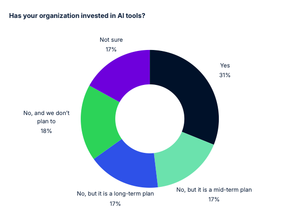
According to the survey, 31% of organizations have invested in AI tools, a figure that has stabilized since 2024. At the same time, the share of organizations with no plans to adopt AI has grown to nearly 18%, highlighting a widening gap between early and late adopters.
What we’re seeing happening is a bottom-up adoption pattern. Nearly 45% of respondents report using AI as an individual productivity tool, while just 18.3% say AI is embedded into organizational processes. Analysts are experimenting with copilots, LLMs, and machine learning to speed up everyday tasks - yet enterprise-wide adoption of AI is primarily among early adopters.
This matters because it reframes AI’s role. AI is increasingly positioned as a force multiplier- taking on repetitive operational work so experts can focus on what matters most: defining the right questions, validating results, and applying spatial insight to real decisions. When properly embedded, AI amplifies experts and operationalizes organizational knowledge.
Yet the challenge ahead now isn’t discovering what AI can do for spatial analytics. It’s building the right conditions— data security, data access, and data integrity — that allows AI to scale safely and responsibly.
2. Cloud-native is a prerequisite, integration is crucial
For many teams, spatial analysis no longer lives on the fringes of the data stack.
The report shows that 68.5% of organizations now run spatial analysis in the cloud, a figure that has stabilized since 2024 after years of rapid growth. Cloud-native spatial analytics is no longer a differentiator—it’s foundational.
However, cloud-native in 2026 means more than hosting GIS tools online. It means processing, analyzing, and visualizing spatial data directly inside cloud data warehouses and lakehouses, without copying or syncing data across systems. This enables organizations to be more effective and agile with spatial data centralized and easily accessible.
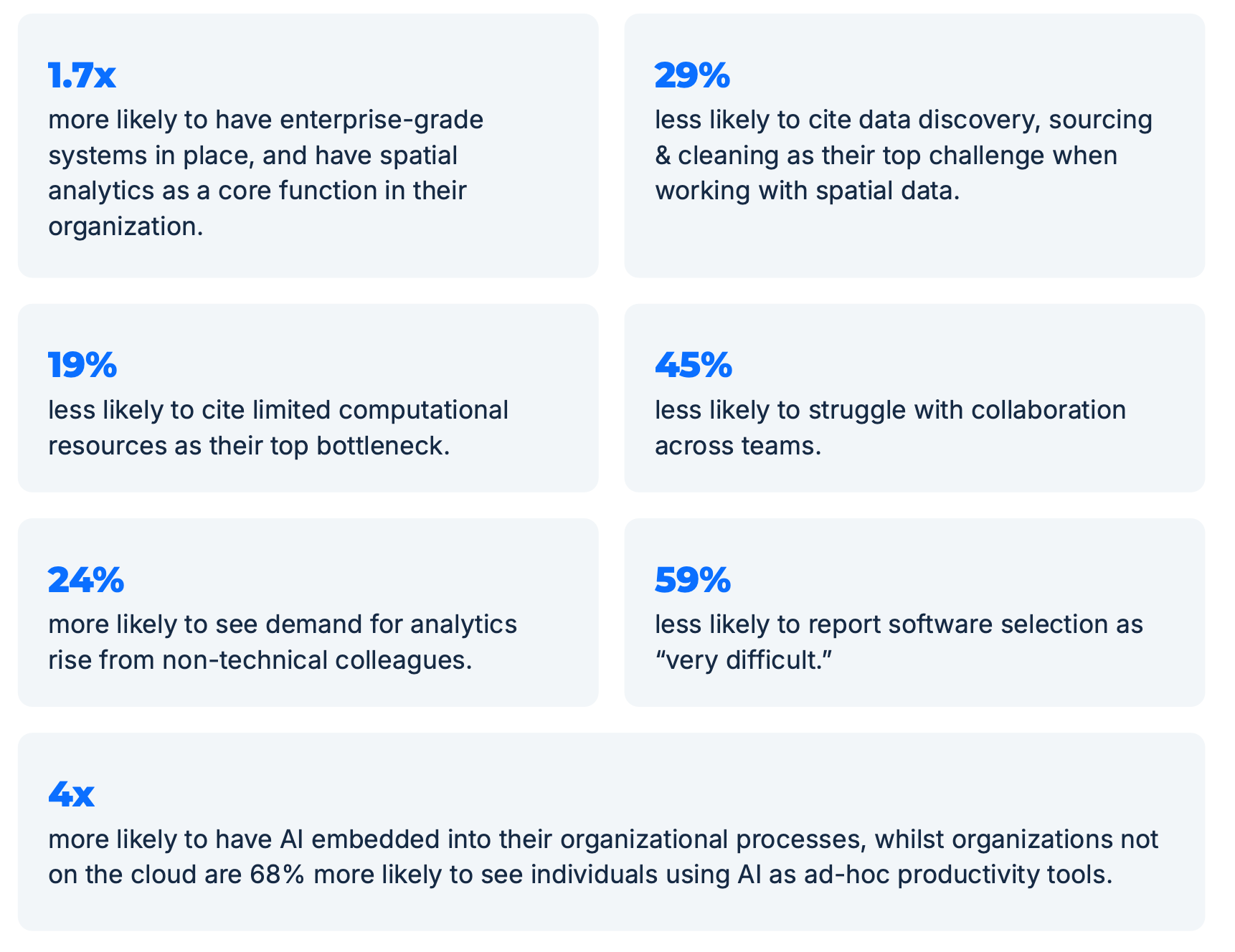
Organizations that operate this way consistently see better outcomes. Survey results show organizations running spatial analysis on the cloud are:
Yet despite these benefits, the report highlights a significant challenge: tool fragmentation.
Most teams rely on between three and eight tools to get work done, spanning traditional GIS platforms like QGIS and ESRI, BI tools like Tableau, and open-source libraries such as GeoPandas and Jupyter.
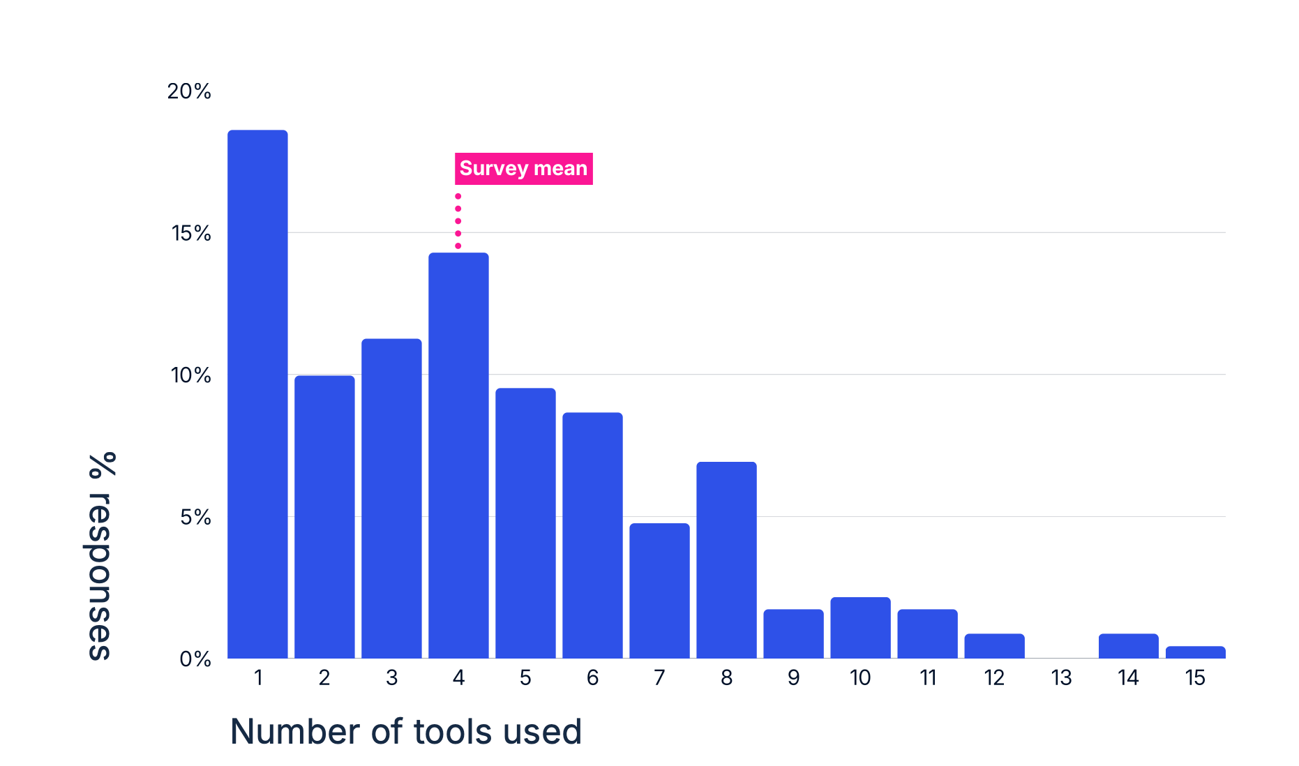
This fragmented ecosystem makes integration the single biggest bottleneck organizations face.
Nearly 30% of respondents report that data access and integration delays are the primary obstacle holding their teams back, far outpacing challenges like slow processing or handling non-technical requests.
In short, the cloud has become the foundation for scalable, governed, and accessible spatial analytics. But interoperability is no longer a “nice-to-have.” It’s essential and the only way an organization’s spatial stack can deliver consistent, enterprise-grade insights.
"The biggest challenge is fragmentation. The field is split between powerful but complex scientific tools (like those using Python and R) and user-friendly but often simplistic business intelligence (BI) platforms. This creates a gap where it's difficult to perform sophisticated, large-scale spatial analysis without deep technical expertise, slowing down decision-making and limiting its adoption across an organization." -- Software developer at a leading tech company
3. Geospatial expertise and skills are more valuable than ever
Nearly 46% of respondents say hiring spatial experts is difficult or very difficult—a figure that has remained stubbornly high across multiple survey editions. At the same time, expectations for GIS roles continue to expand, now commonly spanning cloud workflows, coding, data engineering, modeling, and business communication.
The result is a growing reliance on a small number of highly specialized experts, often described as “spatial unicorns”, to support organization-wide needs.
The report makes one thing clear: hiring alone won’t solve the problem. Instead, leading organizations are shifting toward scaling expertise alongside headcount. That means empowering non-experts with self-service tools, embedding spatial analytics into everyday workflows, and using AI-driven systems to extend expert knowledge across teams.
In this model, GIS professionals don’t just deliver one-off or ad-hoc analyses. They have the opportunity to design the systems, standards, and workflows that allow spatial thinking to scale- amplifying their impact far beyond a single map or dashboard.
"Spatial Analytics is critical to our humanitarian work because it enables data-driven decisions in crisis settings, helping us allocate resources where they're needed most. It transforms complex geographic data into actionable insights, improving the speed, precision, and impact of disaster preparedness and response." -- GIS Officer at a leading global humanitarian initiative
What does this mean for you?
In conclusion, these trends point to a future where spatial analytics is more deeply embedded, strategic, and powerful than ever.
Across this year’s survey, a clear thread connects every challenge: the need to define and operationalize what “good” looks like in a rapidly changing environment.
Organizations that amplify their experts with AI, empower teams with interoperable self-service tools, and put thoughtful guardrails in place for data access and security won’t just keep up – they’ll thrive as spatial analysis becomes central to decision-making in the era of AI. Those that continue to rely on silos, fragmented workflows, or ad-hoc practices risk being left behind.
At CARTO, we’re here to help organizations and spatial experts navigate this changing landscape. This report is our contribution to the conversation, giving teams the clarity and confidence to move forward.
Download the full report to discover the biggest insight. Did you guess it? Explore the data, playbooks, and top predictions for 2028 that will shape the future of spatial analytics.
To learn more, stay tuned for our webinar coming soon!