


CARTO & Snowflake: Location Intelligence for Energy and Utilities
CARTO and Snowflake expanding cloud-native Location Intelligence for Energy and Utility organizations, unifying IoT data for resilient operations.


Build A Clicks-to-Bricks Strategy Using Spatial Data Science
For online-native retailers eyeing growth and expansion, a clicks-to-bricks strategy using geospatial analytics can mitigate risk in site planning

Real-time updated map of addresses inside LA wildfires perimeter
This map shows real-time data of the perimeter of the wildfires as well as the streets most impacted.

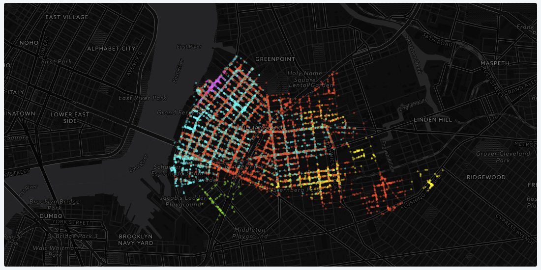
Creative Maps Made with the New CARTO.js 4.0
We held an internal hackathon to demonstrate some of the functionality of our updated Javascript library. Check out what our developers and designers came up with!

Designer’s table. How a lunch became the Design team’s signature
Experience CartoDB's Design Lunch: bonding, fun, & insights. A delightful company tradition fostering camaraderie & creativity.
3 Spatial Data Science Trends to Watch in 2018
Join us at the Spatial Data Science Conference on December 1st where we’ll discuss the biggest trends and challenges in spatial data science.

Map of the Month: City Health Dashboard
Using the City Health Dashboard, city leaders are empowered by local data, and the tools to visualize and analyze that data to improve citizen health in 500 American cities

7 Maps Deriving New Insight From Mobile Data
5.1 billion people own a cell phone. That ubiquitousness, coupled with innate connectivity, that makes mobile devices, and the data generated by them, the world's most powerful tool for understanding people.

The Best Conferences for Location Intelligence in 2017
The definitive list of all conferences covering location intelligence, turning location data into business outcomes.

An update on MVT encoders
Explore enhanced MVT encoding performance with Postgis' St_AsMVT technology, optimizing resources and minimizing network load for efficient vector tile generation.

3 Ways Maps Can Transform Your Digital Marketing Campaigns
In our rapidly evolving online world, digital marketers constantly have to find new ways to make sure their campaigns are reaching the right people with the right message.

Introducing CARTO SalesQuest: Location-Based Sales Analytics
CARTO SalesQuest is a location-based Sales Analytics solution that applies spatial analysis and location data streams to your company’s sales CRM data.

Academy
CARTO & Snowflake: Location Intelligence for Energy and Utilities
CARTO and Snowflake expanding cloud-native Location Intelligence for Energy and Utility organizations, unifying IoT data for resilient operations.
Nagarro & CARTO: Advancing Enterprise AI Transformation
CARTO and Nagarro partner to help enterprises move AI from pilots to production, embedding Location Intelligence into existing workflows and systems.


Unlock trade-area analysis at scale with H3 Isochrones
Scale travel-time analysis with H3-based isochrones in CARTO. Faster joins, overlap insights, and 96–99% time savings powered by TravelTime.

