


Nagarro & CARTO: Advancing Enterprise AI Transformation
CARTO and Nagarro partner to help enterprises move AI from pilots to production, embedding Location Intelligence into existing workflows and systems.


Building COVID-19 Dashboards with Google BigQuery
See how private & public sector organizations use Google Cloud Platform with CARTO to share insights & map visualizations relating to the coronavirus pandemic.


Retail Data Analytics: Social & Credit Card Data
Within Retail Data Analytics we combine social media & credit card data to see how retailers can gain key market insights, optimize footprints, & boost sales.

Simpler Data Science Workflows with CARTO + Databricks
Following the introduction of the Direct SQL Connection read how Databricks can be integrated into the CARTO platform to further empower Data Scientists.
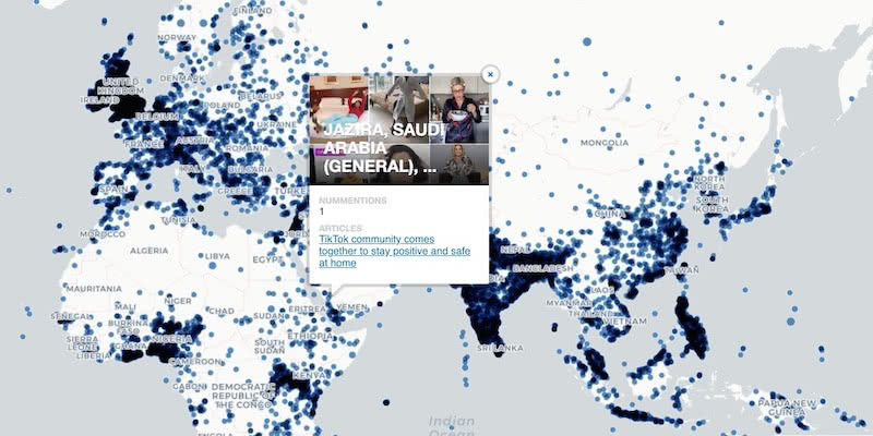
Google BigQuery Visualization: Mapping Big Spatial Data
The GDELT Project describe how to use Google BigQuery to visualize their dataset of online news coverage focusing on COVID-19


MBI's global spatial data available in CARTO's Data Observatory
Michael Bauer International's wide range of spatial data is available through CARTO's Data Observatory to provide socio demographic insights & digital boundaries.

Google Analytics Spatial Data Visualized with BigQuery
Our partner Liveli takes a look at how to visualize spatial data from Google Analytics using BigQuery, gaining deeper insights from website traffic.

Announcing #SDSC20 Online: Spatial Data Science On Demand
Join us this October for #SDSC20, a free virtual conference featuring expert speakers & panelists sharing details of their work in Spatial Data Science.

Comparative Market Analysis Real Estate: Twin Areas
With many retailers consolidating stores & focusing on curbside pickup, comparative market analysis real estate can identify twin areas to maximize revenue.

Integrate CARTO & QGIS Using the New Direct SQL Connection
Integrating CARTO & QGIS through the Direct SQL Connection: access CARTO's database from QGIS using a regular PostGIS connection.

What Geospatial Analysis tells us about Meatpacking & COVID-19
One of our partners, makepath, describe how to use multiple open source spatial libraries for COVID-19 analysis focusing on the US meatpacking industry.


How to use COVID-19 Public Data in Spatial Analysis
A walkthrough of how to use publicly available COVID-19 data sets for spatial analysis using CARTOframes and our Data Observatory.

Supply Chain Network Optimization: SEUR Case Study
A look at how Spatial Analysis & Location Data can provide the tools & techniques for Supply Chain Network Optimization

Academy
Nagarro & CARTO: Advancing Enterprise AI Transformation
CARTO and Nagarro partner to help enterprises move AI from pilots to production, embedding Location Intelligence into existing workflows and systems.


Unlock trade-area analysis at scale with H3 Isochrones
Scale travel-time analysis with H3-based isochrones in CARTO. Faster joins, overlap insights, and 96–99% time savings powered by TravelTime.
Geospatial Foundation Models: Workshop Takeaways
Explore the state of geospatial foundation models, from representation learning to population dynamics, with insights from the CARTO & BSC workshop.

.jpg)