


Nagarro & CARTO: Advancing Enterprise AI Transformation
CARTO and Nagarro partner to help enterprises move AI from pilots to production, embedding Location Intelligence into existing workflows and systems.


COVID-19 Inequality: A Focus on Brazil Coronavirus Maps
With Brazil Coronavirus cases soaring we take a look at the importance of using maps as an awareness tool to ensure an appropriate response.


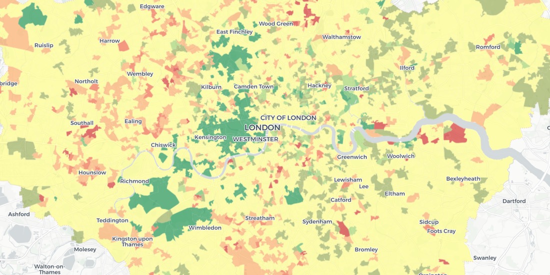
Identifying Walk to Work Hotspots in London
We explore Howsy's research on walk to work rental hotspots across London, with consumers looking to ditch mass transit as they look to change their new normal commute.


Introducing Direct SQL Connection for QGIS, Databricks & more
Connect to CARTO from other GIS or BI tools & database clients: bring your CARTO data to other tools you already use.


COVID-19 Inequality in the US: How Coronavirus is killing more Black Americans
Using data from the COVID Racial Data Tracker we calculate the mortality risk from COVID-19 for Black Americans & visualize the results.

WorldPop in CARTO: global demographic insights at high granularity
WorldPop global demographic data is now available in our Data Observatory for spatial analysis at fine spatial resolution.

US Protest Map & Visualizing Police Violence
Using Spatial Analysis to analyze & visualize Location Data relating to the recent protests & police violence in the US including a protest map.

City Pedestrianization & Micromobility Post COVID-19
To enable safe social distancing cities are pedestrianizing urban areas & building infrastructure for greener transportation & micromobility. Discover how location data can help.
Using Spatial Analysis to Measure UK Gentrification
Read how Spatial Analysis & Machine Learning were used by researchers at UCL to understand neighborhood real estate changes & shape policy making in cities.


New Location Data Available for COVID-19 Recovery Analysis
Location Data Streams from Apple, Unacast, Safegraph, & others now available for Spatial Analysis in our Data Observatory to aid in post COVID-19 recovery.

GIS Indoor Mapping: Workplace Social Distancing
We explore how GIS Indoor Mapping Software can help organizations on their return to work, ensuring best practice in social distancing & contact tracing.

HIPAA Compliance in Geospatial Healthcare Analytics
Read how HIPAA compliance is maintained across the CARTO platform & about key use cases for customers working in the healthcare space.

London vs New York: Which city has the higher average building height?
The City vs Wall Street. Piccadilly Circus vs Times Square. The answer will surprise you as we discover through maps & visualization.

Academy
Nagarro & CARTO: Advancing Enterprise AI Transformation
CARTO and Nagarro partner to help enterprises move AI from pilots to production, embedding Location Intelligence into existing workflows and systems.


Unlock trade-area analysis at scale with H3 Isochrones
Scale travel-time analysis with H3-based isochrones in CARTO. Faster joins, overlap insights, and 96–99% time savings powered by TravelTime.

Geospatial Foundation Models: Workshop Takeaways
Explore the state of geospatial foundation models, from representation learning to population dynamics, with insights from the CARTO & BSC workshop.

.jpg)