


Nagarro & CARTO: Advancing Enterprise AI Transformation
CARTO and Nagarro partner to help enterprises move AI from pilots to production, embedding Location Intelligence into existing workflows and systems.


Meet the growing demand for senior care facilities with a modern site planning approach
Discover why healthcare professionals are turning to location intelligence when deciding when, where, and in what form to open senior care centers to meet medical needs of rapidly increasing senior population.

Driving down distribution costs with Location Intelligence
Businesses continue to search in vain for solutions to a wide range of logistics problems, but in this post we’ll highlight how spatial data science drives logistics optimization.

California Wildfire Maps: How fires and smoke are spreading
These maps of the California wildfire crisis put everything in perspective and show just how daunting it is for emergency responders.
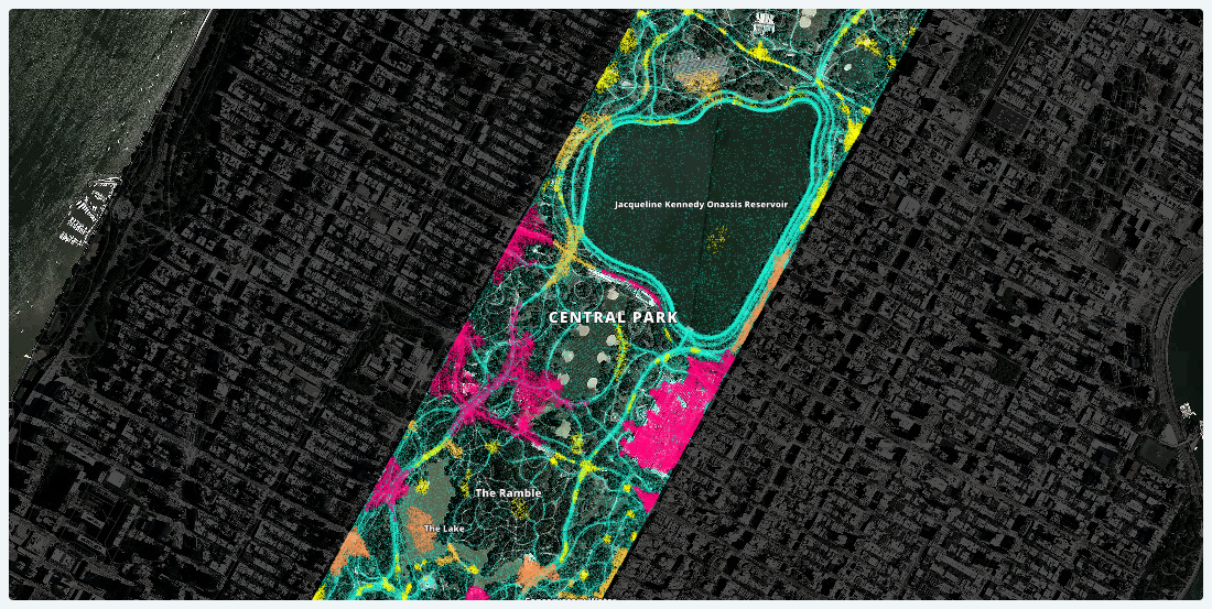
Lessons Learned from Analyzing Over a Million Points of GPS Data
Working with one month of nation-wide GPS data, A Million Walks in the Park explores the use of public spaces, specifically public parks across New York City, to understand social interactions among New Yorkers.


Using Mapbox Vector Tiles in CARTO for Maps & Location Apps
Using Mapbox Vector Tiles in CARTO for Maps & Location Apps

This map shows the communities most vulnerable to Hurricane Irma
We created this map in hopes that public officials and relief organizations can identify the most at-risk neighborhoods and deliver them life-saving resources before and after this disaster strikes.

Introducing CARTOframes: A Python Interface for CARTO
CARTOframes allows data scientists to extract the power of CARTO without leaving their Python environment.

Map of the Month: Pi Project - Connecting the World Through Art
Map of the Month: Pi Project - Connecting the World Through Art

The Future of Location Intelligence
Learn about the latest Location Intelligence trends discussed at CARTO Locations

Our Game of Thrones Basemap is here to unite the Seven Kingdoms
We built a custom basemap of the Game of Thrones world and we’re giving it away for free, with hopes that what you create will help someone unite the seven kingdoms.

A Really Good Guide on Location Intelligence Implementation
Follow this step-by-step Location Intelligence guide to turn your location data into business outcomes.

What Online Retailers Can Learn by Mapping Sales Data
One online retailer based out of New York City was able to measure ROI of their ad campaigns by mapping sales and ad location data.

Academy
Nagarro & CARTO: Advancing Enterprise AI Transformation
CARTO and Nagarro partner to help enterprises move AI from pilots to production, embedding Location Intelligence into existing workflows and systems.


Unlock trade-area analysis at scale with H3 Isochrones
Scale travel-time analysis with H3-based isochrones in CARTO. Faster joins, overlap insights, and 96–99% time savings powered by TravelTime.

Geospatial Foundation Models: Workshop Takeaways
Explore the state of geospatial foundation models, from representation learning to population dynamics, with insights from the CARTO & BSC workshop.

.jpg)