


CARTO AI Agents now integrated with Oracle Generative AI
CARTO AI Agents are now integrated with Oracle Generative AI, enabling secure, governed Agentic GIS and scalable geospatial AI in Oracle Cloud.


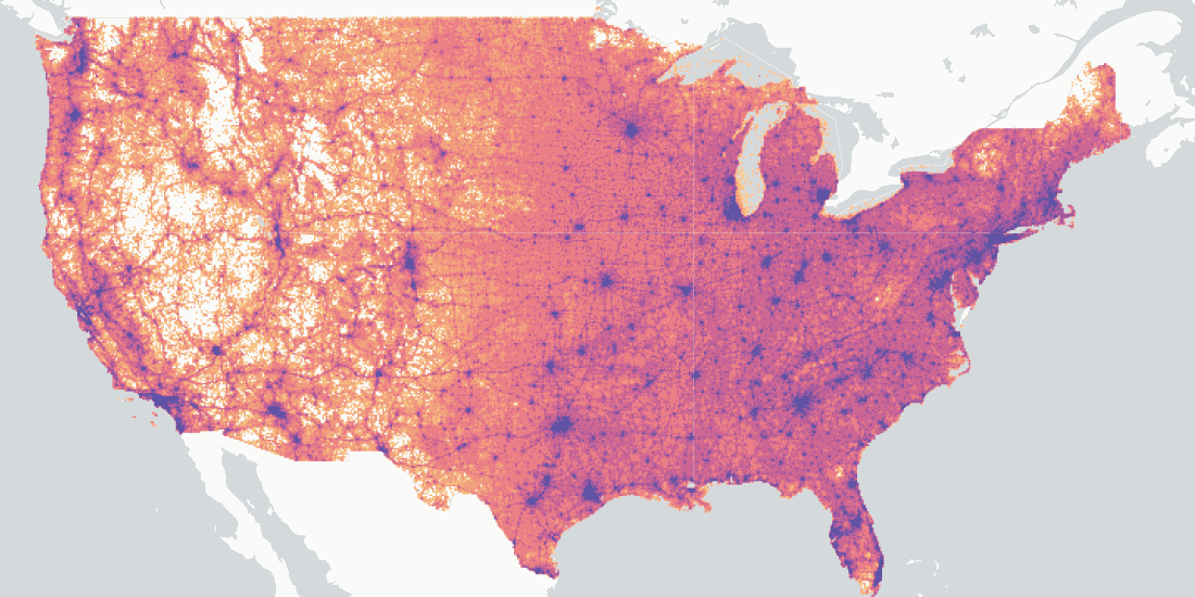
Capturing the Sensitivity of National Wind Energy Potential to Local Siting Challenges
Wind energy is poised to be a significant contributor to national decarbonization goals, while there is enough wind available to power the nation, local siting challenges could have national implications. See how NREL is using location intelligence to better understand wind potential and it’s interaction with national clean energy targets.

A Look Back at 18 Months of COVID Grants & Maps
18 months since CARTO made it’s platform free to public & private sector organizations fighting coronavirus, we look back at some of the hundreds of grants.


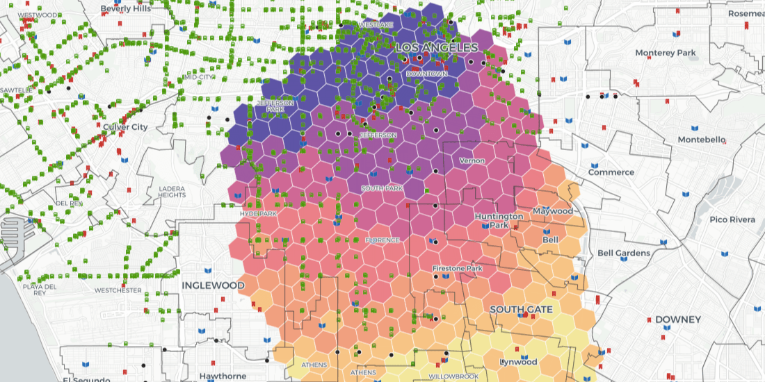
Uncovering Site Selection Strategies using Point of Interest Data
Discover how Point of Interest (POI) data can be used to uncover site selection strategies of leading brands in the US including McDonald's, Starbucks, & Subway


Enhancing Spatial Analytics in Snowflake with CARTO
As part of our commitment to enabling geospatial analysis natively within the cloud, today we announce the launch of our Spatial Analytics on Snowflake with CARTO!

CKDelta’s international human mobility data now available in CARTO
We are pleased to announce our partnership with CKDelta & the inclusion of their human mobility data within our Data Observatory. Learn more & see key use cases.
Making Human Mobility Models Fair, Inclusive, & Private
Discover our Scientific Committee's latest insights when they gathered recently to discuss human mobility data topics including representation, bias, & privacy.

Announcing CARTO’s Return to In-Person Events
We are pleased to announce our return to in-person events! Discover the events we will be attending this year including Big Data LDN, Groceryshop, & ODSC West.


The Data Appeal Company POI & Sentiment Data now available in CARTO
We are pleased to announce our partnership with The Data Appeal Company, a leader in POI & visitor sentiment data, & their inclusion in our Data Observatory

How to Build a Tree Equity Index & Dashboard using BigQuery
Lack of trees is linked to higher temperatures & more violent crime. Discover how to use the BigQuery Spatial Extension & CARTO for React to build a tree score dashboard.

Simplified tileset creation for streamlined app development
Discover the latest updates to CARTO’s BigQuery Tiler, simplifying the SQL code & reducing the processing steps required to ingest & visualize large datasets

#SDSC21: Speak at the largest Spatial Data Science Conference
Want to connect with thousands of Spatial Data Science experts? Speak at #SDSC21 & be part of the biggest & most global community of Data Scientists with spatial expertise

Z Score Visualization: How to Identify Hotspots with BigQuery
Index, or Z Scores, have often been used in geospatial analytics to identify hotspots & rank locations. Discover how to visualize them using Google BigQuery.

Academy
CARTO AI Agents now integrated with Oracle Generative AI
CARTO AI Agents are now integrated with Oracle Generative AI, enabling secure, governed Agentic GIS and scalable geospatial AI in Oracle Cloud.

Spatial Analytics in 2026: What's Changing?
Explore how AI, cloud-native tools, and evolving skills are reshaping spatial analytics in 2026, based on insights from 200+ geospatial experts.


CARTO CLI: Automated CARTO management built for AI Agents
Meet the CARTO CLI: a command-line interface that unifies human expertise, automated pipelines & AI agents into one geospatial operating model.

