


The Client
UNHCR
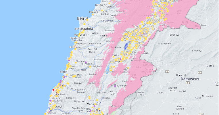
The United Nations High Commissioner for Refugees (UNHCR) is a global refugee agency whose mission is to protect the rights of refugees as well as helping them work towards a brighter future. UNHCR’s Inter-Agency Coordination Unit based in Beirut, Lebanon, is the epicenter of a complex web of refugee support and response where they coordinate 200 organizations.

The Challenge
Aggregating their key datasets and making them accessible to their 200 partner organizations
The Inter-Agency Coordination Unit made maintaining their geospatial data a core priority. The difficulties presented when doing so included the fact that tracking refugee settlements meant a constant on-the-ground-effort as well as enabling all 200 organizations the ability to access, visualize and analyze the data sets.

Results
Real-time visualizations that allowed them to improve their emergency response time
With the help of CARTO’s platform they centralized their data management and created on-the-fly real-time visualizations and apps for improved emergency response. This critical tool is available to all of their partners allowing them to build shared intelligence and insights between hundreds of stakeholders and groups.
.svg)
Why CARTO?
Accessible and user-friendly platform
This project had a critical location component, putting CARTO at the forefront of their collaboration options. Thanks to CARTO’s platform many UNHCR partners who are not GIS experts are able to easily maintain and manage their data, perform spatial analysis and respond rapidly to emergency situations.