


Nagarro & CARTO: Advancing Enterprise AI Transformation
CARTO and Nagarro partner to help enterprises move AI from pilots to production, embedding Location Intelligence into existing workflows and systems.

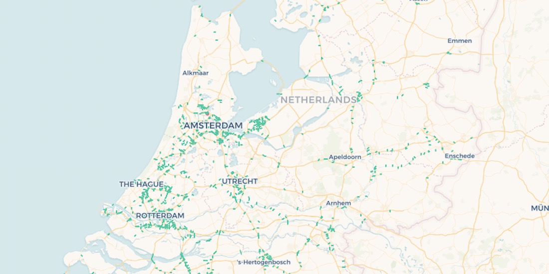
10,000 Dutch Bridges: A Foray into Using BigQuery Connector
Explore how to use our Google BigQuery connector to import large public datasets for geospatial analysis.

Using Spatial Data in Retail Analytics Post COVID-19
A look at how spatial analysis & new data streams such as telco & credit card data can provide insights in a return to retail post COVID-19.

Acquiring New Customers with Geomarketing for Online Retailers
Learn more about Geometric, a Geomarketing solution for Online Retailers made by Anagraph & their work creating COVID-19 dashboards for Canada.
Assessing Potential Impact of COVID-19 on Rural Communities
Read how the Center on Rural Innovation & others used CARTO to determine which rural communities in the US are in need of greater support against COVID-19.

OOH Bounce Back: 2020 Predictions
A look at the impact of COVID-19 on OOH & how geospatial solutions can be used in the post pandemic recovery of the industry.


Open Data on COVID-19 Now Available in Data Observatory
CARTO makes available a set of COVID-19 related datasets as public data in the Data Observatory v2.0

CARTO & Fulcrum partner to provide COVID-19 emergency response solutions
Leaders in data collection & spatial analysis come together to enable organizations to overcome the coronavirus through grants program.


Spatial.ai in CARTO: Geosocial Data Insights During & Post COVID-19
Geosocial Data is now available in CARTO through our partnership with Spatial.ai. See how location-based social media data can be used in spatial analysis.

AsistenciaCOVID-19 Available in Five New Regions of Spain
AsistenciaCOVID-19, the self diagnosis app which CARTO is collaborating on, is now available in five new regions of Spain.


Location Analytics: A Roadmap to Post COVID-19
Everyone has the same question: when will we return to normal? Spatial analysis has helped immensely to contain the spread, now how will it help us recover?

How Location Data Streams Can Be Used to Fight Against COVID-19
A look at how spatial data & analytics can become insightful resources to those designing, monitoring & optimizing responses against COVID-19.

Analyzing Food Access in NYC During COVID-19
We explore how Territorial Empathy are using spatial analysis to visualize food access across NYC during the pandemic.

Academy
Nagarro & CARTO: Advancing Enterprise AI Transformation
CARTO and Nagarro partner to help enterprises move AI from pilots to production, embedding Location Intelligence into existing workflows and systems.


Unlock trade-area analysis at scale with H3 Isochrones
Scale travel-time analysis with H3-based isochrones in CARTO. Faster joins, overlap insights, and 96–99% time savings powered by TravelTime.

Geospatial Foundation Models: Workshop Takeaways
Explore the state of geospatial foundation models, from representation learning to population dynamics, with insights from the CARTO & BSC workshop.

.jpg)