

Spatial.ai in CARTO: Geosocial Data Insights During & Post COVID-19


Social media has become a ubiquitous aspect of our modern connected society with billions of posts tweets and stories posted by users around the world every day. All of these posts represent an ocean of data but that ocean has long been considered unwieldy due to the sheer volume and rawness of the data. Spatial.ai is changing all of that transforming through categorization this vast resource into actionable insights.
It is for this reason that we are so excited to bring Spatial.ai segments into CARTO's Data Observatory. This "Geosocial Data" (or location-based social media data) once organized based on specific personalities or behaviors — referred to as "social segments" — can help retailers to better understand their customers provide greater context to Real Estate Market Analysis be used to optimize product distribution strategies and more. Examples of social segments include:
- Green Thumb
- Animal Advocates
- Connected Motherhood
- Coffee Connoisseurs
- Film Lovers
- Artistic Appreciation
- Mindfulness & Spirituality
- Trend Trackers
- Outdoor Adventures
- & many more
You can explore full details on the 70+ social segments available on Spatial.ai's Data Taxonomy microsite. Segmentation is provided as indices relative to the DMA the county and the nation. Data is currently available for the USA and Canada.
Insights Relating to COVID-19
In recent weeks the rapid spread of COVID-19 has dramatically modified our daily activities transforming our routines behaviors and permeating into our very own personalities. Geosocial Data is not immune to the coronavirus outbreak and one can see its impact in the geosocial segments computed by Spatial.ai. During this period of confinement our social media behavior has changed considerably and informs us of our new hopefully only momentarily reality.
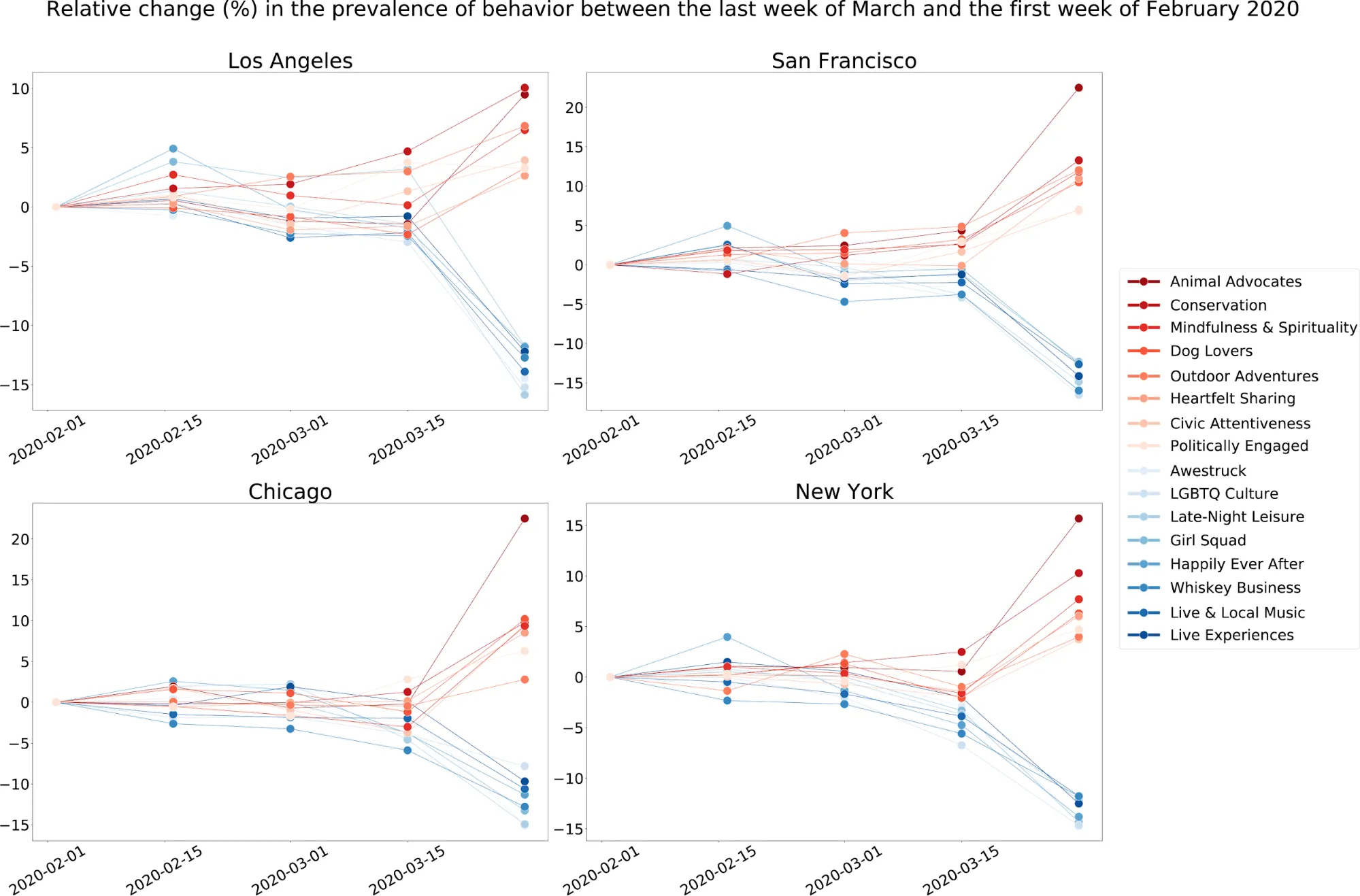
If we look at the data generated recently across several US cities "more social" segments involving for example night-time activities are expected to decline due to lockdown policies; while local and political debates conversation on meditation and grievances are expected to surge. This is reflected in the figure below showing the average relative change in prevalence of behavior (weighted by the number of users) between the first week of February when the outbreak in the US was only in the very early stages to the last week of March 2020.
Focusing our analysis on the area of New York City which has been heavily affected by the virus we can analyze spatially in which census block groups there has been a larger change in prevalence for some of these social media segments.
We are in unprecedented times right now and it is very interesting to see the social implications play out in real time. A brief look at some of the segments rising dramatically show that a larger story is playing out in NYC. People are turning more to their animals for social connection (Animal Advocates). Spirituality has come front and center (Praise & Worship + Mindfulness & Spirituality). Along with grieving (Heartfelt Sharing) citizens are being forced to take a moment and look up and consider the broader implications for humanity (Humanitarian Conservation). Geosocial data provides the unique ability to capture and quantify these seemingly qualitative insights at a geographic level.
Jack Schroder Lead Data Scientist at Spatial.ai
In the maps below we looked into the areas where "Conservation" and "Live & Local music" social segments (see https://taxonomy.spatial.ai for more details) have seen a higher increase and decrease respectively. Geosocial Data can provide institutions and organizations with insights to understand and react to how the COVID-19 spread is affecting our moods and behaviors from the point of view of anonymized and aggregated social network data.
Get Started with Modern Up-to-Date Data Streams
Learn more about CARTO's location data streams and start incorporating data from Spatial.ai and other high-quality data sets into your models and spatial analyses today.
Learn more in our upcoming webinar with Spatial.ai


