.png)


Live maps with automated Workflows integrations are here
Create live, always-updated maps with CARTO by integrating Workflows and Builder. Automate geospatial analysis to visualization in one step.
.jpg)


Today Thousands of Spatial Leaders Gather for #SDSC20
#SDSC20 Online starts today! Join thousands of spatial leaders from around the world over 5 days to discuss & learn about the future of Spatial Data Science.
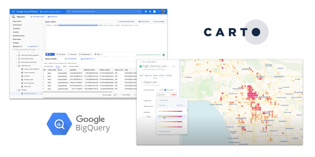
How to Analyze Google BigQuery Data in CARTO
Learn how to visualize geospatial Big Data hosted in Google BigQuery by creating a CARTO instance on the Google Cloud Platform & using our BigQuery Connector.


CARTO for deck.gl: The Best Way to Develop Spatial Apps
CARTO is now available as part of the deck.gl framework & becomes our preferred & recommended library for building spatial applications

CARTO + Placekey: Cloud Native Spatial Linkability
Learn more about our integration with Placekey, enabling universal standard identifiers for any physical place to be used with spatial analysis & visualization.

Indoor Mapping & Airport Routing launched by Aena & Telefonica
Aena, in collaboration with CARTO, Telefónica, & Situm has launched 'AenaMaps', a solution leveraging indoor mapping to provide navigation within its airports.


Upgrades improve CARTO platform performance by > 20%
Following several upgrades to the CARTO platform we are pleased to announce significant performance & security improvements.

Data Monetization: A Complimentary Guide for Enterprise
Download our data monetization guide on how to transform big data into a viable product. See how leading enterprise CDO / CTOs from Vodafone & Mastercard do it.


Unleash the Power of Snowflake with our Latest Connector
Snowflake users can now easily import large spatial datasets from the cloud into CARTO, becoming the first Location Intelligence platform with native support.


Data Observatory: Thousands of Spatial Datasets On Demand
We are excited to announce a new release of CARTO's Data Observatory giving users the ability to explore, subscribe, & manage thousands of spatial datasets.


Improvements to CARTO’s Direct SQL Connectivity
Our Direct SQL Connector now allows easy connection to apps such as Tableau & Power BI using native PostgreSQL connectors, & from SaaS solutions, such as Looker

How to Analyze & Visualize Spatial Data in Databricks
Explore examples of Databricks & CARTO together as part of a collaborative Data Science process including visualizing Big Data sets & creating ETL pipelines.

Dstillery Behavioral Spatial Data available in CARTO's Data Observatory
Dstillery's Behavioral Spatial Data is available through CARTO's Data Observatory to provide market segmentation & geomarketing insights.

Academy
Live maps with automated Workflows integrations are here
Create live, always-updated maps with CARTO by integrating Workflows and Builder. Automate geospatial analysis to visualization in one step.

Introducing User Comments: boost collaboration in your maps
Boost team collaboration with User Comments in CARTO Builder—add, track, and resolve feedback directly on your enterprise maps.

Navigate global risk with MBI CONIAS Political Risk data
Monitor and forecast global political risks with MBI CONIAS data - spatial, predictive, and ready to support smarter decisions in volatile regions.
.png)
