Navigate global risk with MBI CONIAS Political Risk data


Geopolitical instability has the potential to disrupt global operations overnight. Organizations face an urgent need to monitor and respond to these political risks, yet traditional risk assessments often fall short. They’re either too slow, too generic, or too complex to interpret without specialized knowledge.
That’s why we’re excited to announce the launch of MBI CONIAS Self-Explaining Political Risk Data, now available through the CARTO Data Observatory. Developed by Michael Bauer International, this dataset delivers a new standard for political risk assessment, combining spatial granularity, historical context, and forward-looking trend analysis in one unified offering.
Whether it's supply chain disruptions, infrastructure threats, or investment risk, this dataset equips users to make faster, more informed decisions in volatile environments. With seamless access through your cloud-native data lakehouse - no ETL required - users always have access to the latest developments in political risk, regularly refreshed and ready for action.
Why This Data Matters
Understanding political risk isn’t just about knowing where unrest is happening - it’s about knowing why it’s happening, how intense it is, how it has evolved over time, and where it might go next. MBI CONIAS doesn’t just report conflict events - it contextualizes them, so users can evaluate their significance and plan accordingly.
Unlike traditional conflict datasets - which are often static, raw, or require expert interpretation - MBI CONIAS is designed for accessibility. It not only captures the current state of political unrest but also places it within a temporal and spatial framework, including backward-looking insights, conflict attributes, and forward-looking forecasts with more than 80% predictive accuracy, giving users a critical edge in anticipating future risks.
What truly sets this data apart is its global consistency, detailed conflict attributes, and forward-looking intelligence. It captures not just what is happening, but why, and provides regional comparability through standardized methodology - making it ideal for global organizations managing cross-border risk.
About the data
The MBI CONIAS dataset delivers a layered view of political conflict, tailored for in-depth risk analysis:
- Module 1: Conflict Presence – assess current conflicts, including frequency, type, and duration.
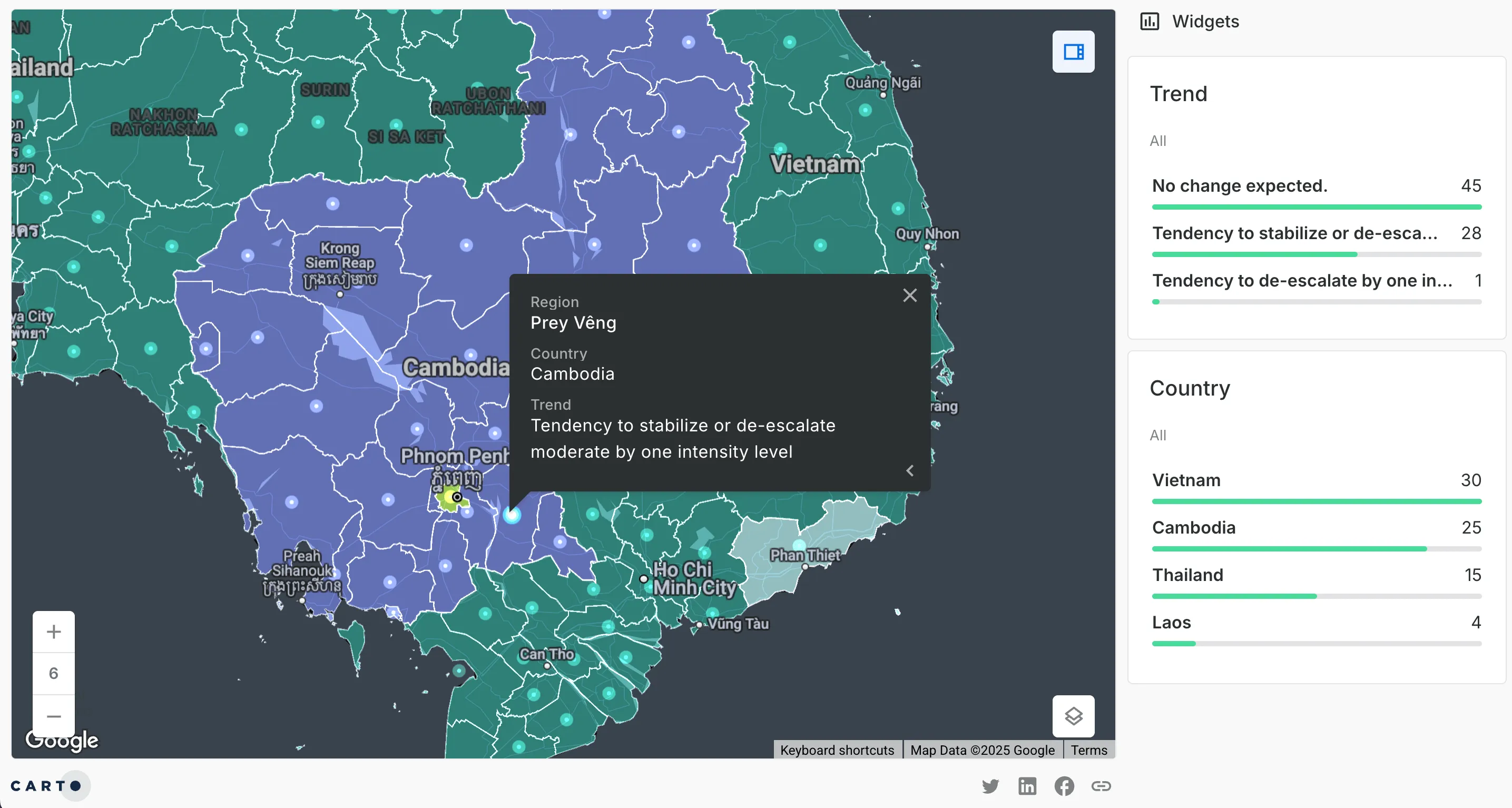
- Module 2: Trend Forecasting – calculate future risk trends based on historical patterns and predictive modeling. Explore this in the map below, or open in full-screen here. This analysis was produced using the December 2024 release of this data.
- Module 3: Conflict Insights – explore rich contextual detail on the underlying causes of conflict, categorized by issues such as governance, resource scarcity, or ethnic tensions.
Each dataset includes standardized geographic identifiers (e.g., ISO codes), making it easy to integrate with your own spatial models. Key metrics include conflict intensity, frequency, impact types (direct vs. indirect), and temporal trends across 12-month windows. Data is available at a global scale with a sub-national resolution and quarterly updates.
Use Cases & Industry Applications
- Financial services: Incorporate political risk factors into investment models and asset valuation.
- Transportation & logistics: Identify high-risk transit routes and adapt supply chain operations accordingly.
- Retail & site planning: Assess regional stability to inform store openings, expansion strategies, or market entry decisions.
- Urban planning & infrastructure: Guide infrastructure investment by understanding conflict exposure at the regional level.
- NGOs & humanitarian organizations: Prioritize operations and resource allocation in volatile environments.
- Government & security agencies: Monitor geopolitical developments and support early warning systems.
This dataset empowers decision-makers across sectors to move from reactive to proactive. Whether planning long-term infrastructure or managing supply chain risk, organizations can leverage up-to-date and localized conflict data to increase operational resilience. Its spatial granularity and predictive capabilities are particularly valuable for any industry exposed to geopolitical volatility – enabling smarter, safer, and more strategic choices.
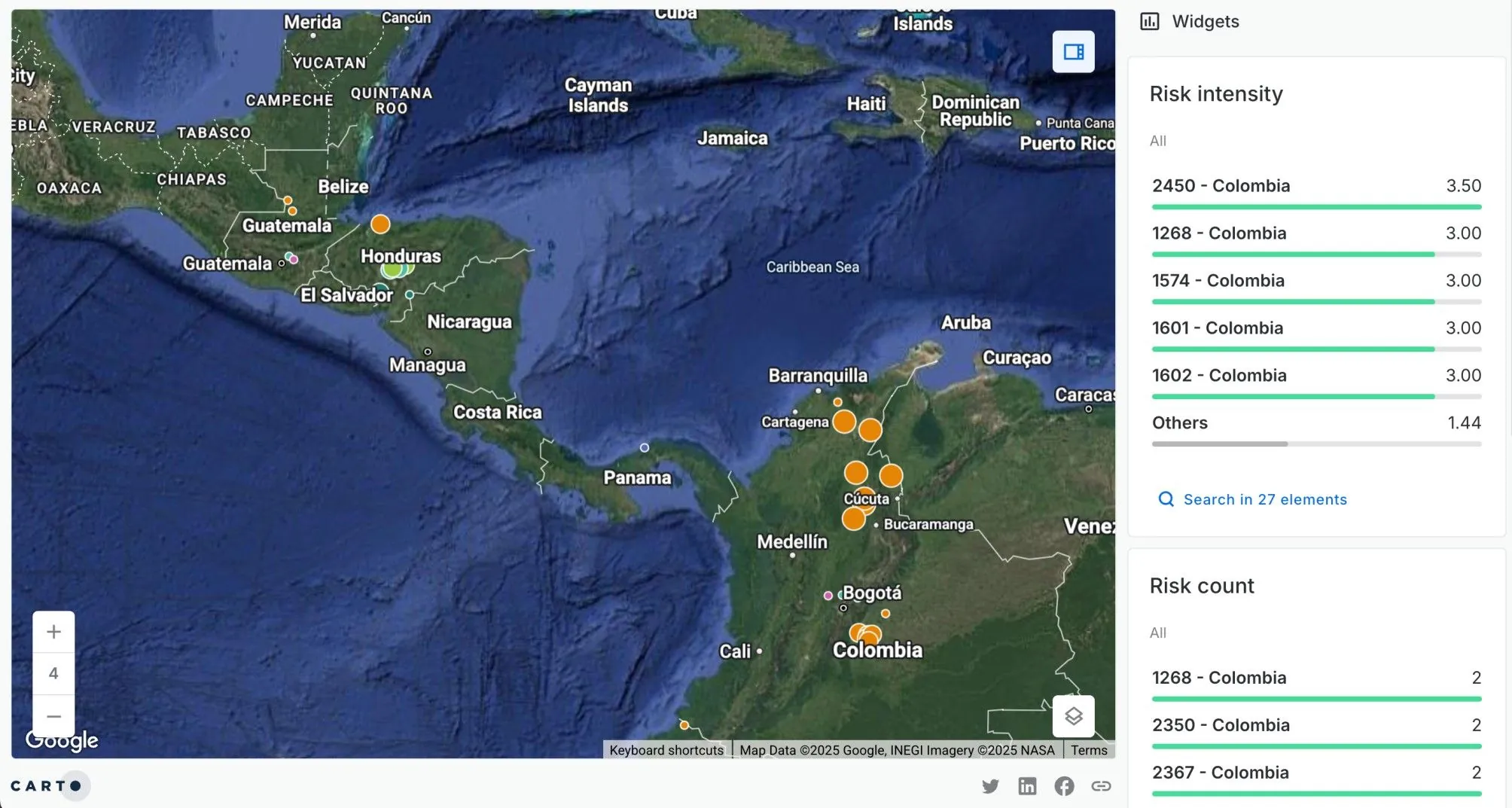
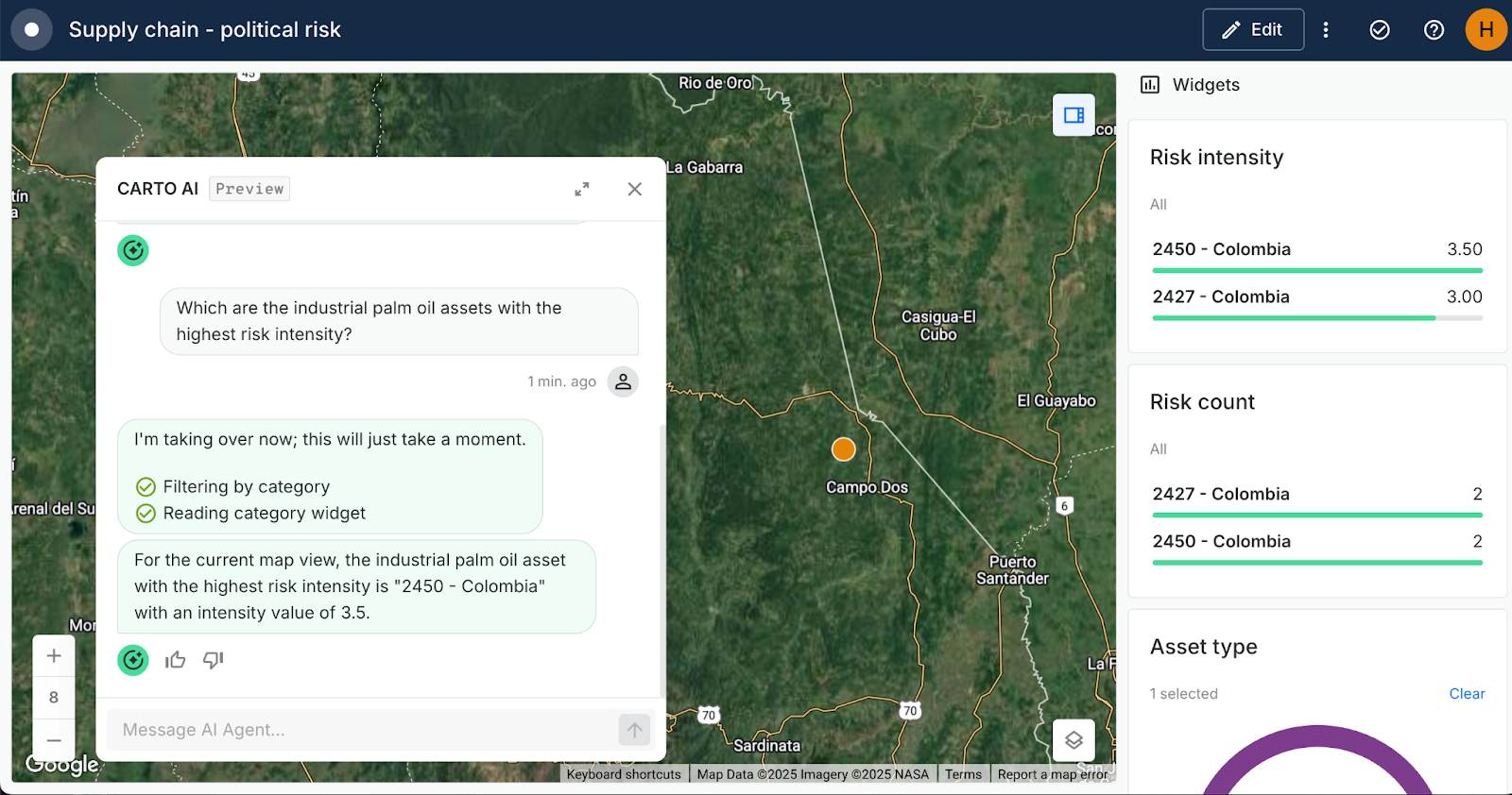
In the example above (open in full screen here, created with the December 2024 release of this data) risk levels from the Conflict Insights dataset have been summarized for each of the locations in a fictional supply chain. This allows supply chain managers to identify areas of the supply chain which may be disrupted and plan mitigating measures, such as shifting resources to other locations. For instance, below you can see CARTO AI Agents being used to pinpoint the component of the company’s supply chain which has the highest political risk.
Get started
In a world where political landscapes can shift rapidly and unpredictably, having access to accurate, timely, and actionable intelligence is no longer optional - it's essential. The MBI CONIAS Political Risk Data empowers organizations to not only monitor global instability but to understand it, anticipate it, and respond with confidence.
Start exploring the MBI CONIAS Political Risk Data in the CARTO Data Observatory, or request a meeting to see how it can enhance your organization’s risk strategy.