.png)


Live maps with automated Workflows integrations are here
Create live, always-updated maps with CARTO by integrating Workflows and Builder. Automate geospatial analysis to visualization in one step.
.jpg)


Integrate CARTO & QGIS Using the New Direct SQL Connection
Integrating CARTO & QGIS through the Direct SQL Connection: access CARTO's database from QGIS using a regular PostGIS connection.

What Geospatial Analysis tells us about Meatpacking & COVID-19
One of our partners, makepath, describe how to use multiple open source spatial libraries for COVID-19 analysis focusing on the US meatpacking industry.


How to use COVID-19 Public Data in Spatial Analysis
A walkthrough of how to use publicly available COVID-19 data sets for spatial analysis using CARTOframes and our Data Observatory.


Supply Chain Network Optimization: SEUR Case Study
A look at how Spatial Analysis & Location Data can provide the tools & techniques for Supply Chain Network Optimization


COVID-19 Inequality: A Focus on Brazil Coronavirus Maps
With Brazil Coronavirus cases soaring we take a look at the importance of using maps as an awareness tool to ensure an appropriate response.


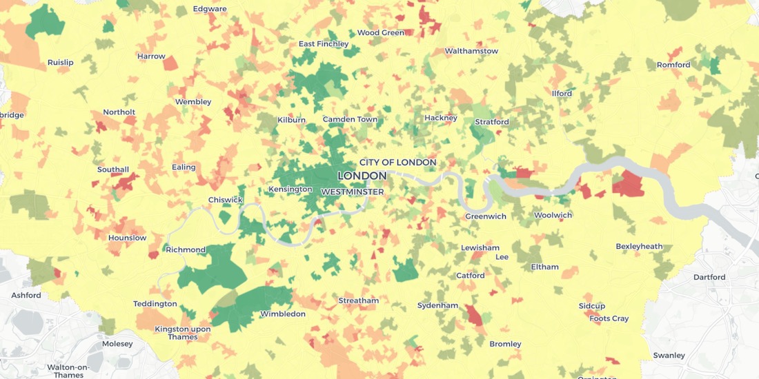
Identifying Walk to Work Hotspots in London
We explore Howsy's research on walk to work rental hotspots across London, with consumers looking to ditch mass transit as they look to change their new normal commute.

Introducing Direct SQL Connection for QGIS, Databricks & more
Connect to CARTO from other GIS or BI tools & database clients: bring your CARTO data to other tools you already use.


COVID-19 Inequality in the US: How Coronavirus is killing more Black Americans
Using data from the COVID Racial Data Tracker we calculate the mortality risk from COVID-19 for Black Americans & visualize the results.

WorldPop in CARTO: global demographic insights at high granularity
WorldPop global demographic data is now available in our Data Observatory for spatial analysis at fine spatial resolution.

US Protest Map & Visualizing Police Violence
Using Spatial Analysis to analyze & visualize Location Data relating to the recent protests & police violence in the US including a protest map.

City Pedestrianization & Micromobility Post COVID-19
To enable safe social distancing cities are pedestrianizing urban areas & building infrastructure for greener transportation & micromobility. Discover how location data can help.
Using Spatial Analysis to Measure UK Gentrification
Read how Spatial Analysis & Machine Learning were used by researchers at UCL to understand neighborhood real estate changes & shape policy making in cities.

Academy
Live maps with automated Workflows integrations are here
Create live, always-updated maps with CARTO by integrating Workflows and Builder. Automate geospatial analysis to visualization in one step.

Introducing User Comments: boost collaboration in your maps
Boost team collaboration with User Comments in CARTO Builder—add, track, and resolve feedback directly on your enterprise maps.

Navigate global risk with MBI CONIAS Political Risk data
Monitor and forecast global political risks with MBI CONIAS data - spatial, predictive, and ready to support smarter decisions in volatile regions.
.png)
