

.png)
.png)


Announcing Deck.gl v9: WebGPU ready & with TypeScript support
Announcing Deck.gl v9! Get ready for next-gen geospatial rendering, including TypeScript support & preparation for WebGPU.


EU Deforestation Compliance with Cloud Spatial Analytics
Streamline your sustainability efforts with our EUDR compliance solution, leveraging FAO and WRI methodologies, powered by Google Cloud and GEE.


Meet CARTO at Google Next '24
Join CARTO at Google Next '24 on April 9th - 11th for cutting-edge spatial analytics insights in cloud tech.


Now in CARTO: NielsenIQ data for building powerful CPG insights
Access powerful CPG insights with NielsenIQ data, now available in CARTO! Visualize trends, optimize strategies, and make confident decisions.
.png)


BT Active Intelligence Location Insights Now Available with CARTO
Access hyper-local footfall insights with BT Active Intelligence Location Insights, now available with CARTO! Explore granular mobility data in the cloud.

H3 Spatial Indexing, accelerated with Snowflake & CARTO
H3 Spatial Indexing is now available natively in Snowflake - learn about our new H3 Acceleration Program and discover how to get started!


Create a Spatial Priority Score to Improve Network Access
Learn how to create a spatial priority score to improve network access for senior citizens. Explore data integration, regression models, and AI insights.

Introducing Workflows Templates: pre-built spatial analysis
Boost efficiency with CARTO Workflows Templates - no-code spatial analysis made easy. Explore pre-built templates for streamlined geospatial projects.

Elevate your real estate property analysis with CARTO & Markerr
Announcing CARTO & Markerr's data partnership! Subscribe to spatial real estate data including transactions, rent and property details.
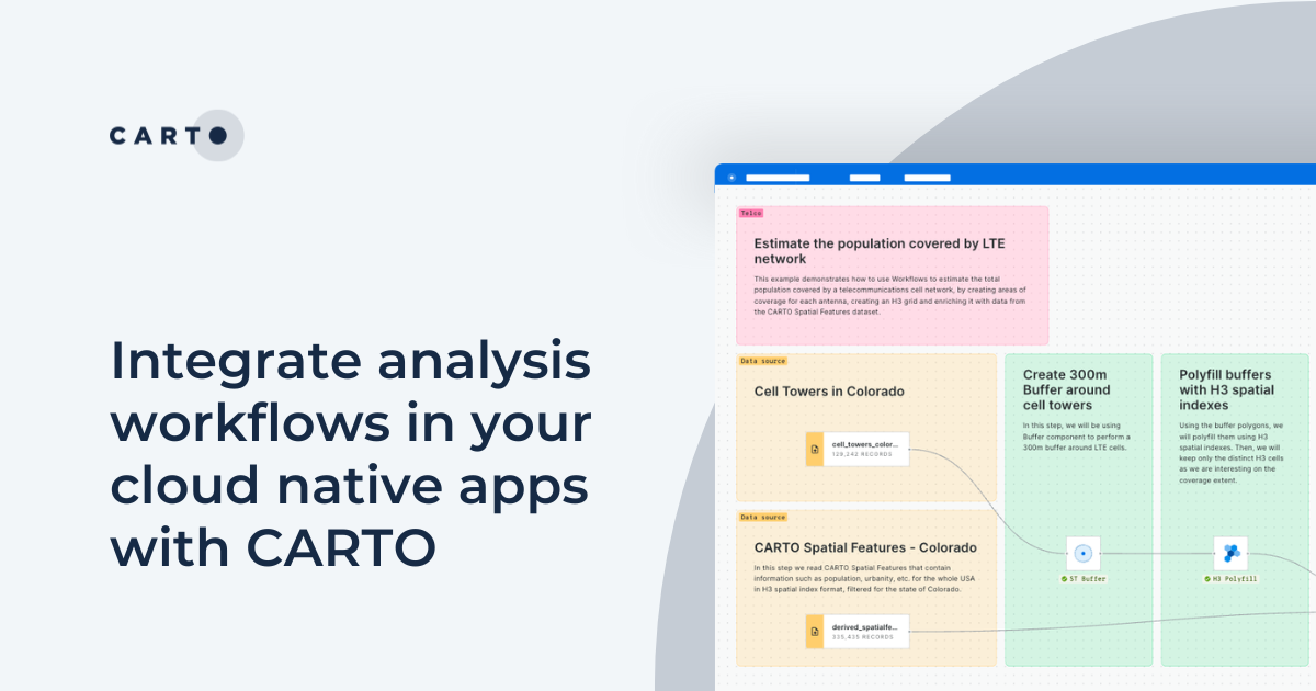

Integrate analysis workflows in your cloud native apps with CARTO
Seamlessly spatial analysis into cloud-native apps; trigger workflows via API, parameterize processes & seamlessly integrate them into spatial apps.

5 Advantages of No Code Spatial Analysis
Is no code for spatial analysis possible? Discover 5 advantages to go no code & see CARTO Workflows in action! Reduce bottlenecks, save time & de-risk.

Geographic Segmentation: How to get started
Get started with Geographic Segmentation with our guide & tutorials. Leverage demographic & consumer data to tailor your strategy & maximize ROI.

Academy
Snowflake Summit 2025 - highlights for geospatial
Discover top geospatial highlights from Snowflake Summit 2025 -from AI to open formats -shaping the future of cloud-native spatial analytics.
From selection to consolidation: 6 ways to optimize site planning
Optimize site planning with data, AI, and real-time insights. Discover 6 of the best strategies in this expert guide from CARTO.

Foundation Models: Transforming the Future of Spatial Analytics
Explore how geospatial foundation models like Google’s PDFM are revolutionizing spatial analytics, from disaster response to urban planning with CARTO.

