

Create a Spatial Priority Score to Improve Network Access


Have you ever thought about using a priority score to enhance network access for senior citizens?
In a world increasingly dependent on digital connectivity, network access remains a critical concern for bridging the digital divide between generations in the United States. That’s why the focus on improving network access for senior citizens has gained prominence following the 2021 Broadband Network investments which aimed, among other things, to tackle this issue.
However, addressing this challenge requires more than financial investments, and Telcos are actively seeking innovative solutions for network development to enhance accessibility. In one of our latest Spatial Spotlight sessions, our in-house data scientist covers one way to use location intelligence to achieve just that.
Keep reading to learn how to integrate various datasets and use CARTO Workflows to:
- Create an eligibility model through regression analysis,
- Generate a priority score for spotting higher priority when there is a bigger proportion of senior citizens with a lower network speed in areas with high urbanity levels,
- Create AI-generated descriptive labels to support your strategic decisions.
Want to replicate this demo using your data? Jump into your CARTO account to get started. Heads up! If you are new to CARTO, you can sign up for a free 14-day trial account.
Data Gathering and Spatial Indexing
For this demo, the data sources include:
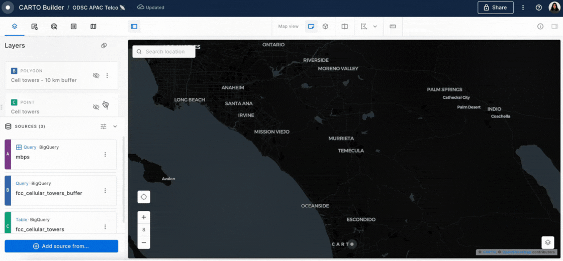
- Telco data with the network speed, average download/upload speed in megabytes per second (MB/s), together with the location of antennas. For this demo, we have built synthetic data to simulate these variables.
- Building height from the USGS; this is required because higher buildings can lower network transmission
- Spatial Features data (from CARTO) is a Quadbin grid (a type of Spatial Index) index containing a variety of demographic, economic, and environmental variables. Key variables for this analysis include urbanity level, working population, the senior population, points of interest (POIs) by category, and elevation.
- Human mobility data (from Unacast) with the number of visitors identified as residents, workers, or from neither of these two categories.
All of these datasets are combined into a single Quadbin grid through the process of enrichment - you can follow this tutorial to understand how this works. Quadbin is a type of Spatial Index - multiresolution, hierarchical grid systems. This type of spatial data is geolocated through a short ID, making them super lightweight - ideal for combining large datasets efficiently. Learn more about Spatial Indexes in our free ebook Spatial Indexes 101!
Using Workflows to Create a Spatial Priority Score
Replicate this analysis in three phases, using CARTO Workflows:
Phase 1: Eligibility Model Creation
The first step is to create an eligibility model using regression analysis, allowing the use of multiple variables to predict network speeds, using the following input variables:
- Buildings height
- Terrain elevation
- Number of people over 15 years old
- Total number of points of interest (POIs) in the area
- Number of visitors of different categories (residents, workers, others)
This model predicts the network speeds according to the selected predictors; the lower the predicted network speed is, the higher the priority for a location is. This estimation allows for a better scope in determining priority areas for network enhancement.
See below the step-by-step on how easy it is to input the data, filter, and train your regression model to make predictions with CARTO Workflows. Moreover, you can save the results, check the model performance, and share the process with anyone in your organization.
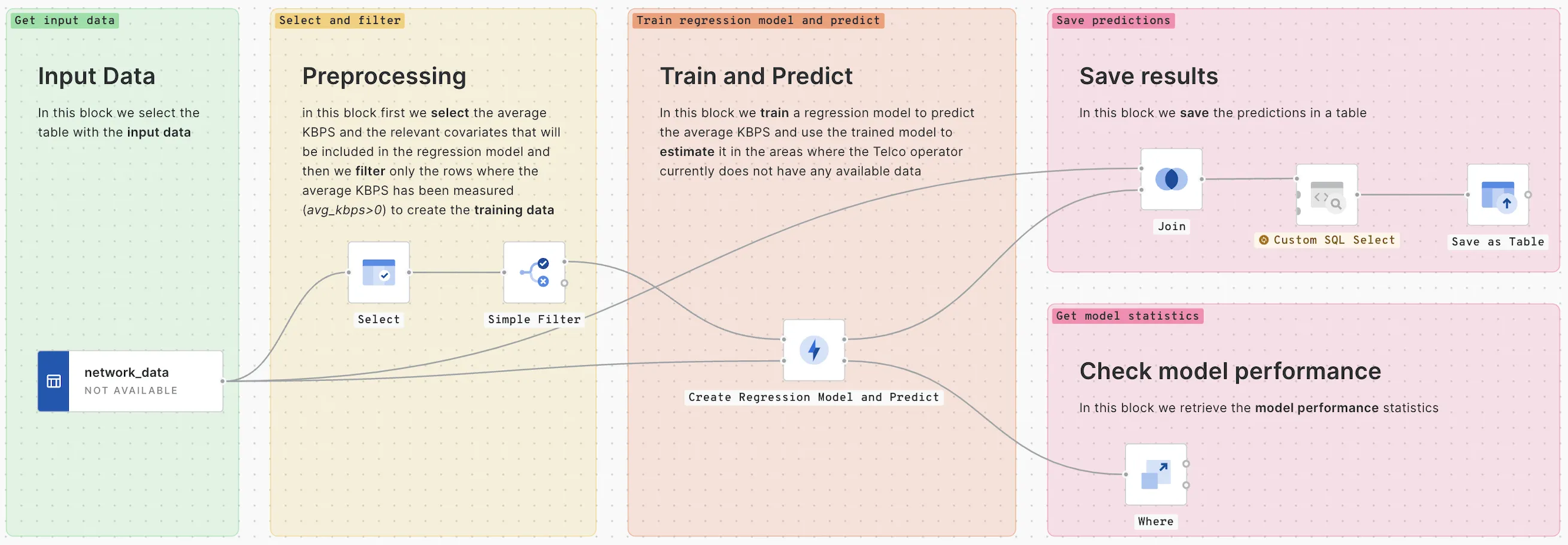
- Select your table with the input data.
- Select the average MB/s and the relevant covariates that will be included in the regression model and then filter only the rows where the average MB/s has been measured (avg_mbps>0) to create the training data.
- Train the regression model to predict the average MB/s and use the trained model to estimate the areas where there is no data available.
- Save the predictions in a table.
- Retrieve the model performance statistics to check the model performance.
Watch in detail how this eligibility model was created.
Phase 2: Priority Score Generation
To create a priority score you can use spatial composite methods in your Workflow. You need to combine the proportion of senior population, the reverse of the estimated network speed, and the level of urbanity (from remote to very high-density urban). These combinations will indicate higher priority when there are more senior citizens with a lower network speed at high urbanity levels. Adjusting weights and scaling functions ensures that the priority score reflects the specific importance of each variable.
See below the step-by-step on how to implement a composite score using CARTO Workflows.
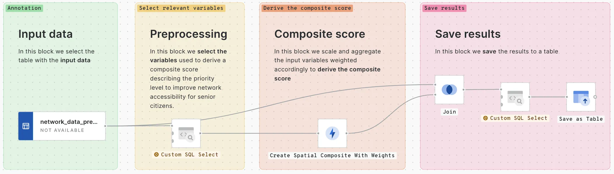
- Select your table with the input data.
- Select the variables used to derive a composite score describing the priority level to improve network accessibility for senior citizens.
- Scale and aggregate the input variables weighted according to the to derive the composite score.
- Save your results in a table.
Watch in detail how to generate this priority score.
With this method, you get a score emphasizing areas with higher senior populations, lower network speeds, and increased urbanity as focal points for improved connectivity. You are one step closer to bridging the digital divide 🗼
Phase 3: AI-Generated Descriptive Labels
In this next step, use an AI model (LLM) to facilitate better comprehension for non-technical stakeholders. This model automatically generates descriptive labels for different priority score categories. The labels will aid in interpreting the significance of priority scores, simplifying the decision-making processes.
See below the step-by-step on how to implement AI-generated descriptive labels using CARTO Workflows.
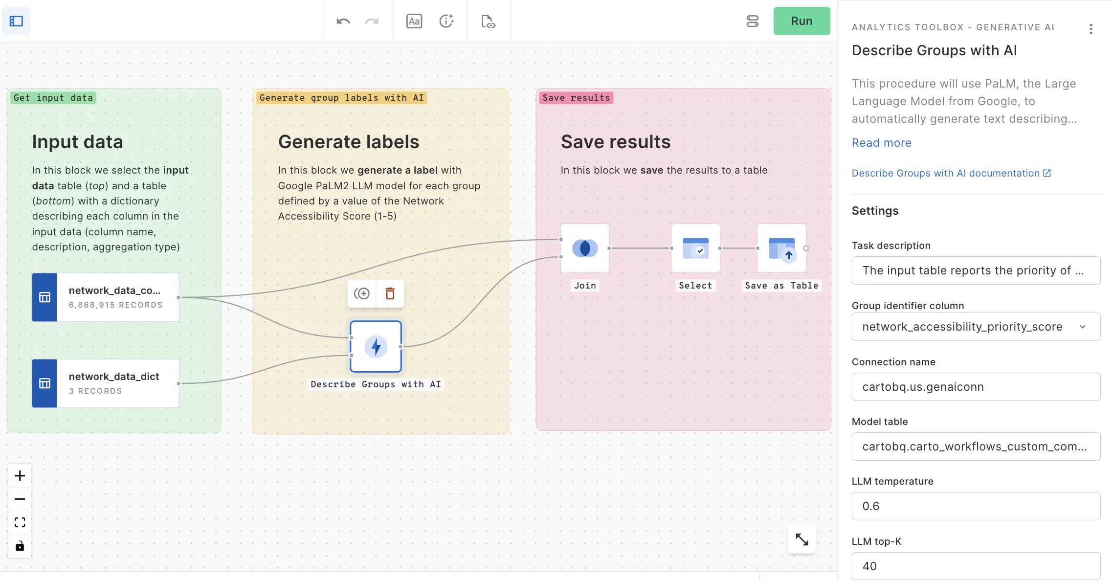
- You need at least two tables at this stage. One table with the input data and one table with a dictionary describing each column in the input data (column name, description, aggregation type)
- Generate a label with the Google PaLM2 LLM model for each group defined by a value of the new Network Accessibility Score, from 1 to 5.
- Save your results in a table.
Watch in detail how to generate these AI-generated descriptive labels.
The methodologies employed in this comprehensive analysis showcase CARTO's spatial analysis capabilities, including regression models, composite score generation, and AI-driven insights - all underpinned by a no-code approach with CARTO Workflows.
The resulting priority score maps showcase regions warranting immediate attention. Areas with higher senior populations, lower network speeds, and increased urbanity indicate a pressing need for enhanced network connectivity services.
Conclusion: The Perks of Location Intelligence to Bridge the Digital Divide
The Spatial Spotlights are our series of weekly 15-minute webinars with an expert from the CARTO team to share tips & tricks, use case demonstrations, and best practice guidance. This episode showcases the role of Location Intelligence in identifying areas that need enhanced network accessibility. With your CARTO account, you can replicate this demo using your data and start generating actionable insights to provide better network access for senior citizens.
Watch the video to dig deeper into this dynamic spatial analysis and its implications for improving the digital divide between generations in the United States.
If your goal is to automate processes without specialized coding skills, tools like our cloud-native solution, CARTO Workflows, allow you to use a visual, drag-and-drop interface to construct analytical algorithms intuitively. Browse our most popular Workflow templates for telco.
Request a Demo Now
Are you working for a telco company and have other needs that require Location Intelligence? Request a demo with one of our specialists and scale your geospatial analysis.


