PLATFORM

Spatial analytics for the modern data stack

Analyze, visualize and develop with spatial data at limitless scale in your data warehouse.

Visual of the spatial analytics platform for the modern data stackVisual of the spatial analytics platform for the modern data stack

Cloud native

Work on top of your cloud data warehouses to avoid duplication, or wasted time on complex data cleaning or ETL processing.

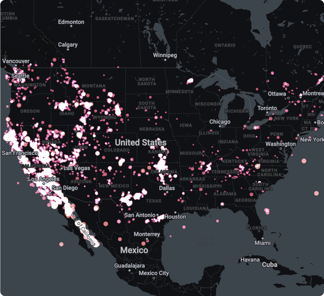
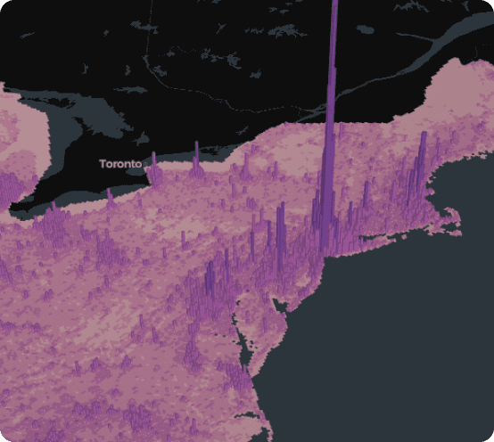
Scalability without limits

Experience a seamless performance by analyzing and visualizing several layers using massive datasets, directly from your cloud data warehouse.

Accelerated time-to-insight

Design, run and share flexible analysis workflows and build interactive dashboards, using powerful low-code drag-and-drop visual tools.
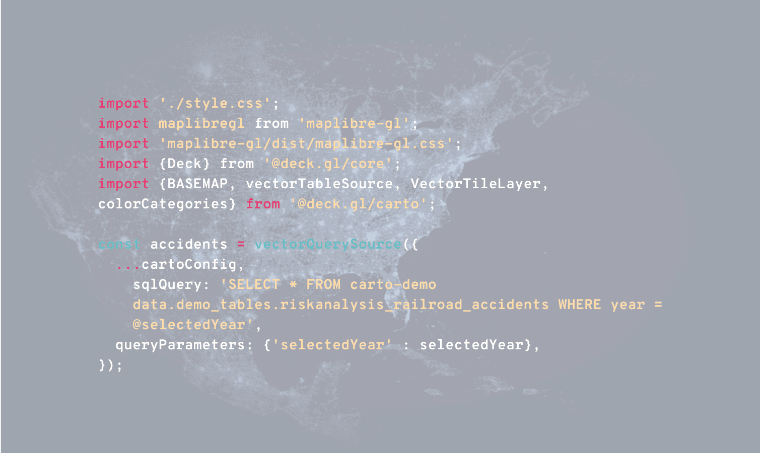
Simplify data prep and scale your analysis, using our no-code design & visualization tools

Analyze

Powerful analytics with low-code data prep & analysis design tools

Whether you’re a data analyst starting in location analytics or a data scientist creating advanced spatial models, accelerate your work with CARTO Workflows, our drag-and-drop analysis design and automation tool.

Explore Workflows
Powerful analytics with low-code data prep & analysis design tools

Combine the power of the cloud with +100 advanced spatial functions

Our Analytics Toolbox extends the spatial analysis and data processing capabilities of the leading cloud platforms with a collection of advanced functions and procedures.
Explore the Analytics Toolbox
VISUALIZE

Unmatched data visualization capabilities

Build rich, dynamic data visualizations directly from your cloud data warehouse with CARTO Builder. Visualize billions of data points with ease. Create and share interactive dashboards that take your data storytelling to the next level.
Explore Builder
Unmatched data visualization capabilities, a visual of a map
Widgets using Builder
Map visualization using Builder
Visualization of several layers using Builder
DEVELOP

Rapid, cost effective development tools

Reduce the time and cost to develop location-based apps with the most comprehensive APIs and development toolkit available. No need for backend APIs, ETLs or hosting data in an intermediate mapping infrastructure.

See Documentation
CARTO for developers
Examples of app development using CARTO for Developers
Builder showing a map
CARTO for developers is framework agnostic
How to access CARTO for developers

Pick your data warehouse to learn more

Experian logoExperian logoExperian logoExperian logoExperian logo
FEATURED STORIES

Get inspired by our customers

“Considering spatial data in our aggressive expansion plans has been a key part of our success. By designing our territories in CARTO, we’ve been able to improve customer satisfaction significantly - working closely with our grocery store partners.”

Neera Chatterjee
Senior Product Manager at Instacart
Read story

"Working with the CARTO platform has helped take our Location Intelligence strategy to the next level. The platform’s rich set of data analytics features and cloud-native approach helps us deliver outstanding insights that fuel our strategy, execution, and performance measurement."

Michal Klis
Head of Location Intelligence at Allegro
Read story

"CARTO’s Location Intelligence platform lets us visualize massive sets of data hosted in Google BigQuery. Thanks to this cloud-native approach to spatial analytics, we have overcome challenges related to scalability and security, and can serve our customers even better."

Seamus Abshere from Faraday
Seamus Abshre
CTO & Co-founder of Faraday
Read story

"By partnering with a world-class Location Intelligence platform provider we’ve been able to unlock unique spatial insights from our mobile event data--opening new lines of business."

David Fierro
Big Data Tech Lead at Vodafone Business
Read story

“CARTO is an expert in geolocation tech, and when you think of a project requiring the use of data and maps… you just think of them. Launching a new project, which in reality is almost a service, can be scary. But as the weeks pass, and you see people saying that it has been useful for them or that they are thinking of changing neighborhoods thanks to the application, you know that the efforts have been worth it.”

Iván Fanego
Branded Content & Social Media Manager
Read story
FEATURED STORIES

Get inspired by our customers

“Considering spatial data in our aggressive expansion plans has been a key part of our success. By designing our territories in CARTO, we’ve been able to improve customer satisfaction significantly - working closely with our grocery store partners.”

Neera Chatterjee
Senior Product Manager at Instacart
Read story

"Working with the CARTO platform has helped take our Location Intelligence strategy to the next level. The platform’s rich set of data analytics features and cloud-native approach helps us deliver outstanding insights that fuel our strategy, execution, and performance measurement."

Michal Klis
Head of Location Intelligence at Allegro
Read story

"CARTO’s Location Intelligence platform lets us visualize massive sets of data hosted in Google BigQuery. Thanks to this cloud-native approach to spatial analytics, we have overcome challenges related to scalability and security, and can serve our customers even better."

Seamus Abshere from Faraday
Seamus Abshre
CTO & Co-founder of Faraday
Read story

“CARTO is an expert in geolocation tech, and when you think of a project requiring the use of data and maps… you just think of them. Launching a new project, which in reality is almost a service, can be scary. But as the weeks pass, and you see people saying that it has been useful for them or that they are thinking of changing neighborhoods thanks to the application, you know that the efforts have been worth it.”

Iván Fanego
Branded Content & Social Media Manager
Read story

"By partnering with a world-class Location Intelligence platform provider we’ve been able to unlock unique spatial insights from our mobile event data--opening new lines of business."

David Fierro
Big Data Tech Lead at Vodafone Business
Read story

More than 12,000 datasets to enhance your analysis

Easily design and automate advanced data processing and analysis pipelines natively on the leading cloud platforms using our intuitive drag-and-drop interface.

Truly enterprise-ready

Our enterprise-grade security, authentication and data access controls let you distribute your analysis securely with stakeholders. Create secure connections to your data warehouse, give access to your users with SSO, and share your analysis safely.

Need some help to kick-start your geospatial project?

Our Professional Services & Support teams can help you accelerate projects, drawing on their expertise in app development, design, spatial data science and GIS.
Professional Services
Our Professional Services & Support teams can help you accelerate projects, drawing on their expertise in app development, design, spatial data science and GIS.
Meet the team
Support
We offer a full range of support options, helping you make the most of CARTO’s spatial data and analysis.
See our support package

Related content

Report
Modernizing the Geospatial Analysis Stack

The ultimate handbook for navigating the new geospatial landscape. Learn to optimize your tech stack for bigger, faster and more collaborative spatial analysis.

Download now
Blog
Dynamic Tiling for Highly Performant Cloud-Native Maps

Elevate cloud-native mapping of big data with CARTO's Dynamic Tiling. Seamlessly integrate interactive maps in your apps without compromising speed.

Read more
Blog
Why Use Data Warehouses for Geospatial Analysis

Why to use BigQuery, Snowflake, Redshift & Databricks for geospatial analysis? Explore now a real-life example.

Read more