


How Iceberg, GeoParquet & CARTO are reshaping geospatial
Discover how GeoParquet, Iceberg, and CARTO are transforming geospatial analytics with cloud-native, scalable, and open data architectures.

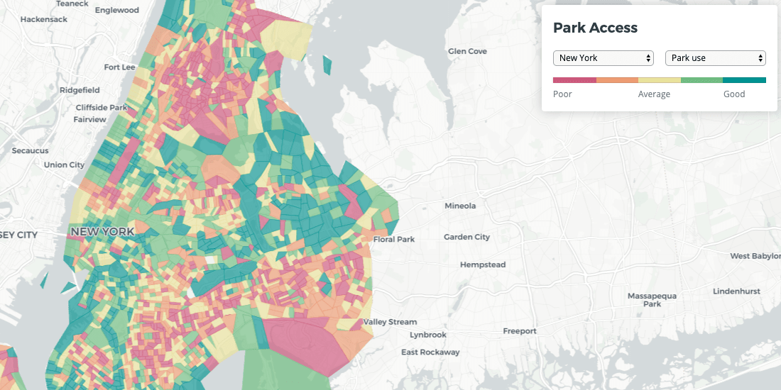
Quantifying Park Use in American Cities: Spatial Models and Novel Measures
Learn how cities can use spatial modeling to more accurately assess park use to inform planning and facilities decisions


Magnify your Analysis: Statistical Downscaling to Enhance Spatial Resolution
From understanding the dynamics of a business, to modelling physical and biological processes, selecting the proper spatial scale matters.


Spanish Residential Real Estate data in CARTO with Tinsa Digital
With new technology solutions and modern, verified data, real estate analysis no longer needs to be carried out in manual and rudimentary ways


Map of the Month: Bringing Smallholder Coffee Farmers out of Poverty
Enveritas leverages Location Intelligence to visualize global coffee production and poverty levels among farmers, as they work towards a more sustainable global coffee industry


Site Planning for Market Coverage Optimization with Mobility Data
This case study shows how to use human mobility data to optimize market coverage in your site planning process for improved outcomes

Spatial Solutions for the SDGs - COP25
In anticipation of COP25, we wanted to explore some of the ways that spatial data analysis can help to achieve the SDGs and invite you to several events to discover it yourself!

Google Fusion Tables Turndown: An Alternative to Keep Mapping
If you're trying to find a Google Fusion Tables alternative, CARTO has you covered. Keep mapping and much more with our full stack Location Intelligence platform.

Announcing #SDSC20 - Where Will You Join Us?
Through dozens of sessions exploring the impacts of powerful analysis, SDSC exemplified why Spatial is so important - but also made clear that Spatial is just getting started

Calculating Catchment Areas with Human Mobility Data
Traditional approaches like isochrones or buffers fail to capture where people visiting a specific location actually come from. Learn how to build better Catchment with Human Mobility Data.


Spatial Analysis: Private Equity's Secret Weapon
Which types of funds invest in spatial analysis? How do they use location data in screening & portfolio management? We discuss the role of Data Science.

Mapping Your Salesforce Data: CARTO in Einstein Analytics
CARTO's Salesforce Lightning app component works seamlessly with Salesforce, integrating complete mapping capabilities with Einstein Analytics Dashboards

PostGIS Day: A future, post GIS
Is GIS dead? No, but it is undergoing a transformation - and we're excited to see how spatial analysis can continue to change our world.

Academy
How Iceberg, GeoParquet & CARTO are reshaping geospatial
Discover how GeoParquet, Iceberg, and CARTO are transforming geospatial analytics with cloud-native, scalable, and open data architectures.

Live maps with automated Workflows integrations are here
Create live, always-updated maps with CARTO by integrating Workflows and Builder. Automate geospatial analysis to visualization in one step.

Introducing User Comments: boost collaboration in your maps
Boost team collaboration with User Comments in CARTO Builder—add, track, and resolve feedback directly on your enterprise maps.
.png)
.png)