Use cases


7 Reasons Why CPG Marketers Are Turning To Location Analytics
Discover how CPG/FMCG marketers & CMOs can use geospatial analysis & data to evolve their analytics to rapid consumer changes in the new normal

React to the Changing Face of Retail DIY with Behavioral Data
With COVID-19 causing dramatic shifts in consumer spending behavior, DIY & other retailers can leverage geospatial data to discover new revenue opportunities.


Using Data & Maps to Analyze England's Response to COVID-19
As cases of Coronavirus rebound, having an effective Test & Trace system in place is crucial. A new dashboard with maps evaluates the NHS response in England.

Modern Distribution Management Transformation in CPG
Modern Distribution Management, encompassing supply chain network design & logistics optimization, is going through a transformation. See why spatial is key.
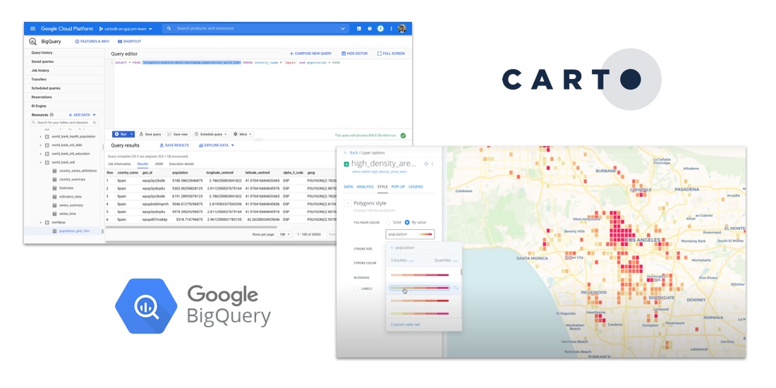
How to Analyze Google BigQuery Data in CARTO
Learn how to visualize geospatial Big Data hosted in Google BigQuery by creating a CARTO instance on the Google Cloud Platform & using our BigQuery Connector.

Indoor Mapping & Airport Routing launched by Aena & Telefonica
Aena, in collaboration with CARTO, Telefónica, & Situm has launched 'AenaMaps', a solution leveraging indoor mapping to provide navigation within its airports.

How to Analyze & Visualize Spatial Data in Databricks
Explore examples of Databricks & CARTO together as part of a collaborative Data Science process including visualizing Big Data sets & creating ETL pipelines.

What is Fleet Management & Best Spatial Practices
What is Fleet Management & how can Location Intelligence be used to improve efficiency, reduce costs, & provide compliance? We explore.

Improving Healthcare Access with BigQuery Tiler
Identifying high impact health facility locations with CARTO's BigQuery Tiler & open-sourced geospatial Big Data.

Using Location Intelligence to Combat Litter with PMI
In partnership with Philip Morris International, Litterati, & Cortexia, read how Spatial Data is being used to combat litter beginning with Lisbon, Portugal.

Map of the Month: Coffee Supply Chain Traceability
For our Map of the Month read how Enveritas use CARTO to analyze the traceability & sustainability of coffee supply chains around the world.

Fintech Spatial Data Science Masterclass with J.P.Morgan
Read a summary of the DeepFin (where Fintech meets Deeptech) Investor Masterclass we recently held with J.P.Morgan, a leading global financial services firm.

Academy
.jpg)
Telco dashboards: Turning accessible data into actionable insights
Discover how CARTO enhances data accessibility, empowering decision-makers with actionable insights to improve network access for senior citizens and communities.

The first 5 maps everyone needs to make with CARTO
New to CARTO? Start with these 5 essential maps! Learn how to analyze proximity, work with big data, integrate real-time updates, and leverage AI-driven insights.

Unlock raster analytics & visualizations - now in your lakehouse!
Unlock raster analytics in your lakehouse! Analyze & visualize raster data natively in CARTO for unmatched scalability, efficiency & cost savings.