Cotality’s Location Intelligence Insights - now in CARTO


Today, we are excited to announce a strategic alliance between Cotality™ and CARTO to bring next-generation Location Intelligence (LI) solutions to organizations seeking to make smarter, faster decisions with authoritative property data.
This alliance combines Cotality’s rich geospatial and property-level datasets with CARTO’s powerful spatial analysis platform to help users visualize change, assess risk, and uncover development opportunities with ease. Whether evaluating growth potential, selecting new locations, or mitigating risk, decision-makers can now access timely, accurate property insights in a highly intuitive environment.
Keep reading to discover how you can apply these insights to drive smarter decisions across your organization!
A Strategic Integration: Cotality™ + CARTO
Today, we’re excited to announce that Cotality’s industry-leading geospatial data products are now available in the CARTO platform via the Data Observatory, allowing you to subscribe to the data directly from your lakehouse! This data allows users to combine Cotality’s expansive parcel and property datasets - spanning over 157 million parcels across the U.S. - with CARTO’s advanced spatial analytics to derive actionable location-based insights.
With this integration, CARTO users can seamlessly explore property insights across the United States, allowing them to pinpoint new opportunities for investment, enhancements, and servicing. By removing the friction of complex data acquisition, data onboarding, and data management, the strategic alliance enables faster, smarter decision-making powered by ready-to-use, high-quality location data.
At Cotality™, we believe that location intelligence should be both powerful and accessible. By integrating our geospatial data products into the CARTO platform, we’re enabling organizations to unlock deeper insights, faster—whether they’re evaluating land use, planning infrastructure, or identifying growth opportunities. This alliance is about turning property data & insights into clear, actionable intelligence.Anand Singh, Vice President of Product Management at Cotality
We’re thrilled to welcome Cotality’s rich parcel and property datasets into the CARTO Data Observatory. This integration empowers our users with high-resolution, ready-to-use location data that’s essential for making smarter decisions across industries—from real estate and logistics to finance and infrastructure. It’s a major step forward in democratizing access to geospatial intelligence.Vanessa López Eslava, Data Partnerships Lead at CARTO
About Cotality’s Location Intelligence data
Cotality’s geospatial data products bring unparalleled depth and precision to property and parcel analytics across the United States. Now accessible via CARTO’s Data Observatory, this integration unlocks new potential for organizations to drive smarter decisions with ready-to-use location data - straight from their lakehouse environments.
Cotality™ offers two powerful datasets:
- SpatialRecord – The most comprehensive single-source solution for U.S. property attributes and parcel boundaries, covering over 157 million parcels nationwide. Enriched with ownership, zoning, tax, valuation, structure, and legal details, SpatialRecord helps users ground their analyses in accurate, high-resolution data.
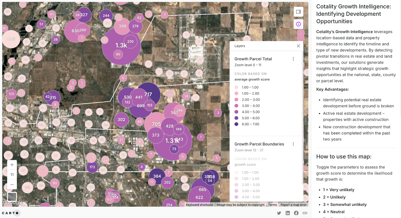
- Growth Intelligence – An AI-driven analytics layer that detects critical changes in land use and real estate development. By surfacing indicators of development activity before they appear in traditional datasets, Growth Intelligence empowers users to act on early growth signals and gain a competitive advantage.
Both datasets are anchored by Cotality’s CLIP® ID (Cotality’s Integrated Property identifier), a persistent and standardized ID system for tracking property changes over time. This ensures seamless linking, enrichment, and analysis across geospatial and business systems.
Turning Cotality’s data into actionable strategy
Cotality’s data fuels real-world applications across industries. With nationwide coverage and granular detail, users can scale analyses from the parcel level to national insights.
Key industry applications include:
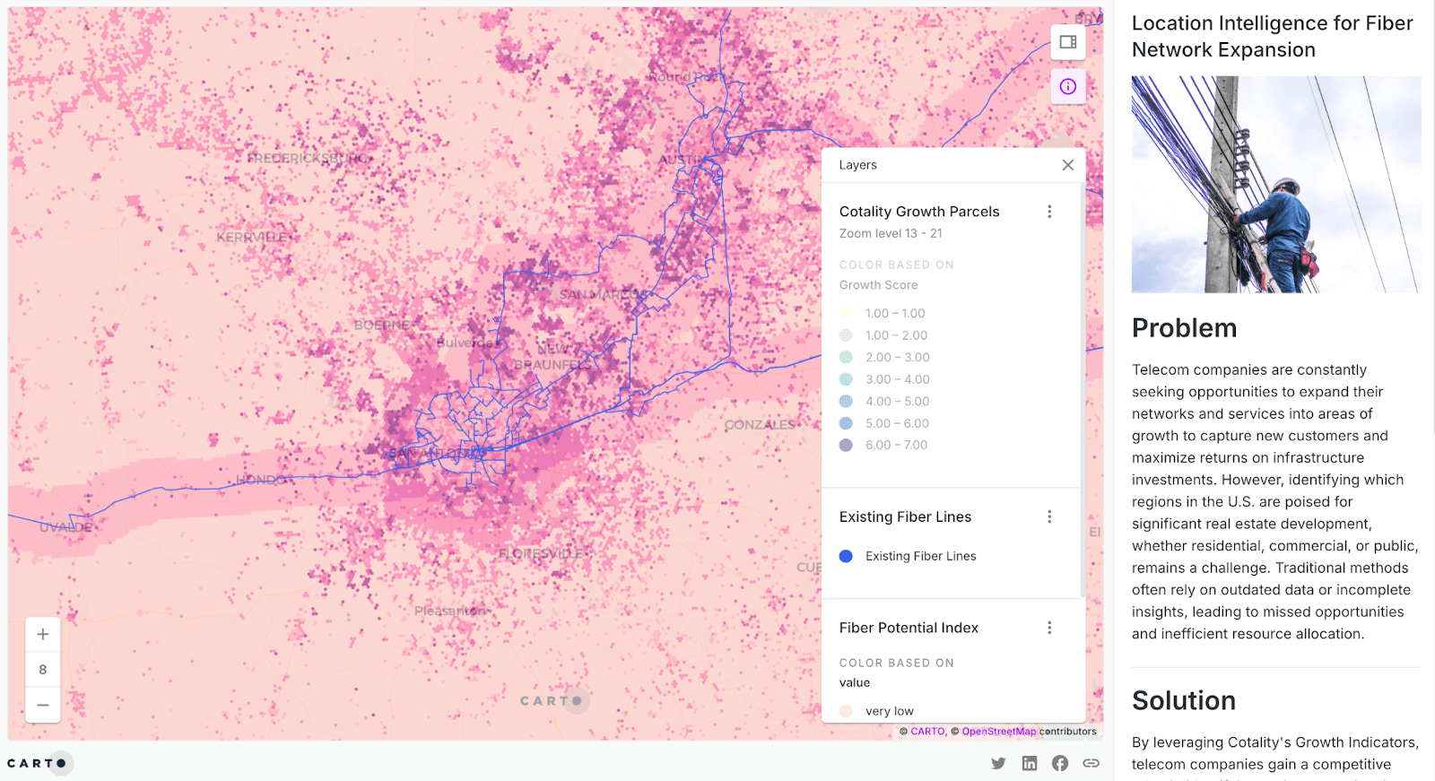
- Infrastructure planning for utilities & telecom: Use property intelligence to guide infrastructure investments like fiber deployment or renewable siting - prioritizing locations based on ROI and growth potential.
- Retail site selection: Leverage Growth Intelligence to detect early signs of land development - crucial for identifying high-growth areas before construction begins.
- Transportation & logistics optimization: Enrich route planning and customer service with accurate geospatial context, helping logistics providers streamline operations and enhance delivery intelligence.
- Asset valuation & risk assessment: Real estate and insurance professionals can validate parcel boundaries and property attributes for accurate appraisal and underwriting. Check this out in action in the example below, where CARTO AI Agents are being used to interrogate the value of parcels in Downtown Miami which are at a high risk of flooding. You can explore the interactive version of this map here.

Get started with Cotality™ data in CARTO
Getting started is simple. You can explore and subscribe to Cotality’s datasets directly via the CARTO Data Observatory:
- Log in to your CARTO Workspace or sign up for a 14-day free trial.
- Head to the Data Observatory catalog and search for Cotality.

- Select Request Subscription and a member of the CARTO team will be in touch to discuss your requirements and set up the subscription, directly from your lakehouse! In the meantime, you can select Access free sample to start exploring the data!
Once subscribed, you can immediately start using the data within your CARTO environment - no need for local downloads or custom ETL pipelines. Whether you're enriching models, building dashboards, or generating predictive insights, Cotality data is ready to power your next project.
Start your journey!
Ready to see how Cotality’s data can transform your decision-making? Request a free demo with one of CARTO’s geospatial experts to explore how you can get started today!