GERSifying Overture Places: A Seamless Path to Richer Insights


Imagine you’re an analyst at a regional insurance company. Early one morning, a moderate earthquake rattles San Francisco. Within minutes, leadership wants to know: Which businesses are in the affected zones, and how can we contact them?
You can start with two free and open datasets: the free Overture Maps Foundation POI layer and an earthquake hazard polygon layer. With CARTO you can easily connect these to identify a narrow set of the highest-risk businesses, such as coffee shops, grocery stores, dental offices.
So far you’ve identified where the risk is, but your attributes are limited to the basics Overture provides: business name, category, and location. You can’t yet answer who to contact or which industries are most affected. That’s what this article will help you do - all with a process known as GERSification.
Get GERSified
So, what exactly is GERSification?
Overture’s Global Entity Reference System (GERS) makes data sharing, onboarding, and joining easier via common, open, accessible IDs.
Sounds simple enough, right? But here’s where the value is. GERSification isn’t just about linking datasets more easily - it’s about eliminating one of the biggest bottlenecks in data-driven decision making: integration. By using shared IDs, organizations can blend spatial data sources instantly, accelerating time-to-insight and reducing costly engineering work. For teams under pressure to respond fast - like our earthquake scenario - that difference translates directly into faster, smarter action.
Connecting open and premium data sources
GERS IDs are shared across Overture partner companies - including data vendors like Precisely - who publish layers with GERS bridge files providing lookups between datasets. This means you can connect the Overture POIs to other datasets with no new spatial matching.
Once linked, your hazard-zone POIs can be enriched with any additional attributes your vendors provide - such as business contact details, NAICS codes, human mobility metrics, or demographic profiles.
As more providers release GERS bridge files, your analysis becomes even more powerful. Multiple datasets can be combined into one unified view, with every enrichment anchored to the exact same points of interest. The result: consistent joins, accurate analysis, and richer insights with every new layer you add.
The GERS ID isn’t just a link - it’s the backbone of a multi-source, multi-vendor data strategy. It lets you start with open data and scale effortlessly toward a comprehensive, premium-powered view of the world.
Let’s head back to the San Francisco earthquake to see this in action.
GERSification in action: identifying businesses at risk
Let’s explore the example of leveraging the GERSification process to source contact details of businesses at risk from an earthquake in San Francisco.
To follow along, you’ll need a CARTO account (you can sign up for a free 14-day trial here) as well as access to Overture data via your cloud data warehouse - check out our guide to learn where and how to access these.
Step 1: Locating businesses at risk
The first step here is to load the free Overture Maps POI layer and an earthquake hazard polygon data (sourced from the USGS Shakemap API) into CARTO Workflows - our low-code tool for automating spatial analysis. A simple Spatial Filter can be performed to work out which POIs are located inside the highest-hazard zones surrounding the San Andreas fault. You can explore this on the CARTO Builder map below.
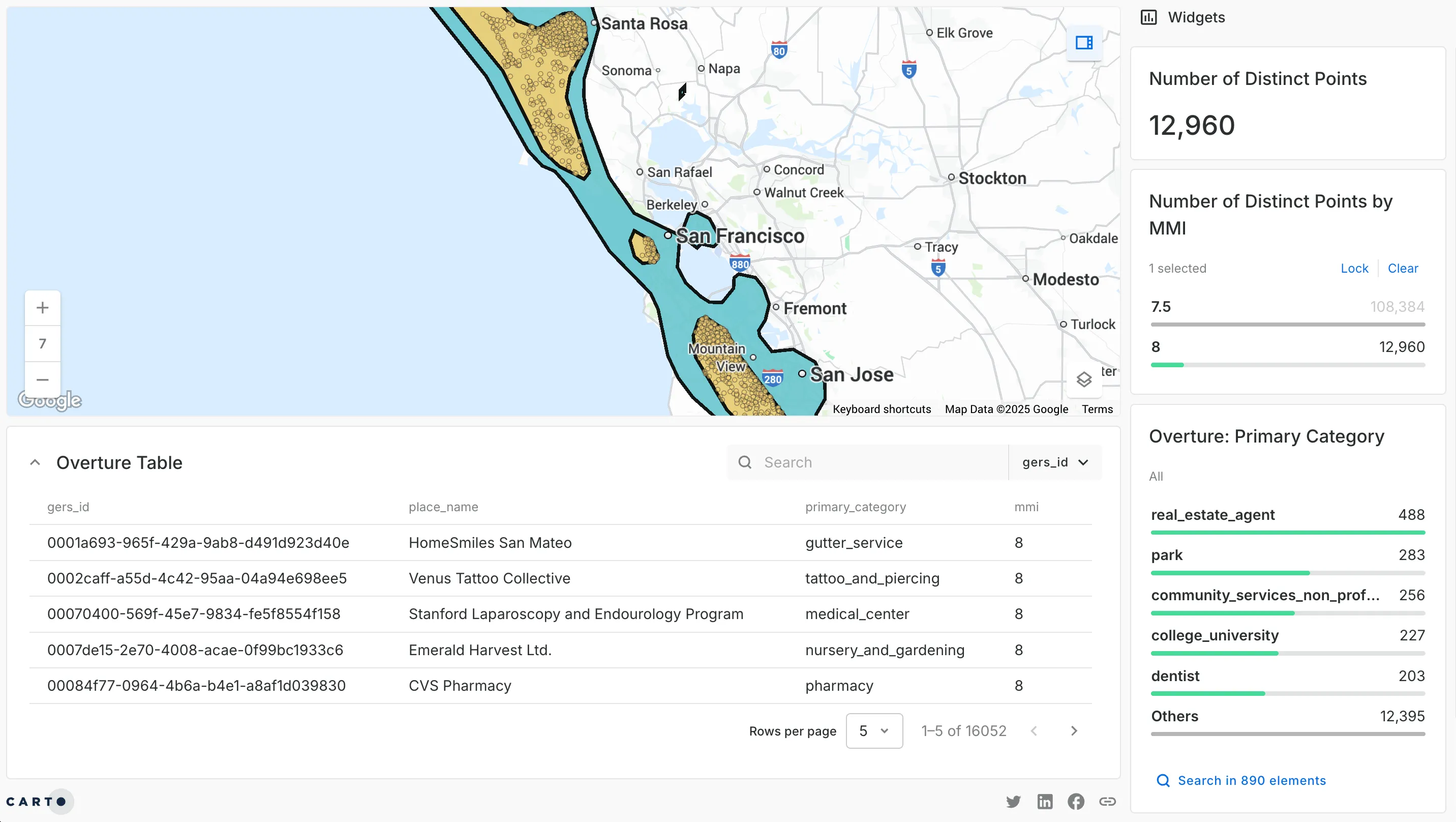
Now you’ve identified where the risk is, you need to go beyond the basics Overture provides, bringing in commercial data with premium attributes like ownership details and contact phone numbers.
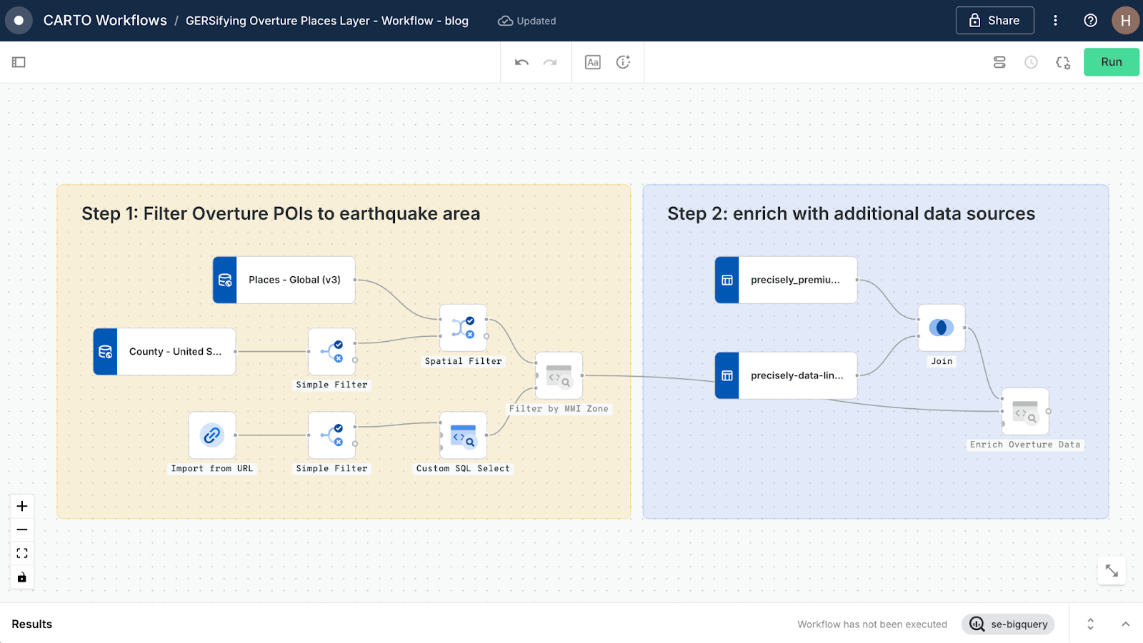
Step 2: Enriching with additional data sources
Back in our Workflow, you can see where we’ve already filtered our Overture POIs to the most heavily impacted areas - let’s build on this.
The next step here is to bring in Precisely’s Point Of Interest data and its accompanying GERS bridge file. Each Precisely key is linked to a corresponding GERS ID. We use a Join component to link the two together, enabling us to pull in premium attributes like business ownership and contact info - all without having to undertake a slow and potentially imprecise spatial join.
Step 3: Visualize - and use - the results
In CARTO Builder, we can now visualize these enriched results, with the hazard zone overlaid with the hundreds of affected businesses color-coded by industry.
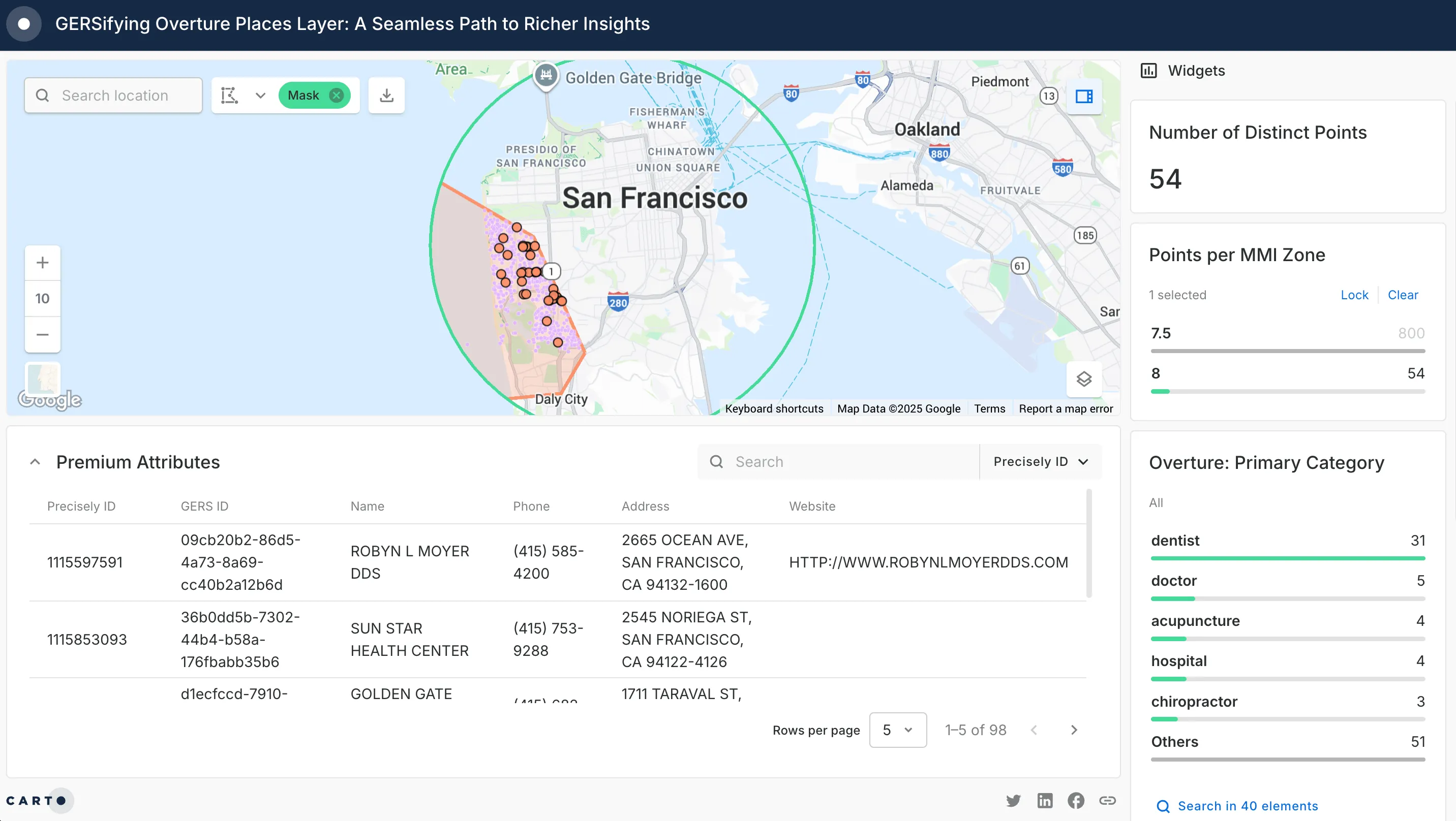
With the GERS IDs in place, the same workflow can easily bring in different datasets in the same way. These are all anchored to the same points of interest: human mobility for retail planning, vehicle traffic for transportation studies, or demographic profiles for community outreach.
From open data to actionable insights
By starting with free and open datasets like Overture, teams can prototype and test ideas rapidly - without waiting on procurement cycles or complex integrations. As those ideas mature, partners within the GERS ecosystem make it easy to layer in premium attributes that take the analysis further.
Your “GERSified” workflow is designed to adapt, reuse and grow. Any data provider supporting GERS can be dropped into the same process, instantly joining their attributes to your existing POIs with no need to redo spatial joins or rebuild pipelines. Because compatible providers publish standardized bridge files, every new dataset slots neatly into place - keeping your analysis consistent, accurate, and future-proof.