CARTO AI Agents: now in public preview!


What if making sense of your spatial data was as easy as having a conversation? With CARTO AI Agents - it is!
2025 is set to be the year where AI Agents become more than just hype - but actually start to revolutionize the way organizations derive insights from spatial data - and CARTO is excited to be leading that charge!
Today we’re excited to announce that CARTO AI Agents is now available in public preview! Our cloud-native, AI-powered solution empowers anyone - no matter their skill level - to derive actionable insights from spatial data using natural language prompts. No more waiting on specialists or struggling with complex tools; use CARTO AI Agents to break down barriers to spatial analysis, helping organizations act faster and smarter. Keep reading to learn how to get started!
Supercharge your productivity with AI-generated spatial insights
Spatial analysis has transformative powers for businesses, but often insights are trapped behind a “skills paywall.” Analysts often end up stuck working on repetitive tasks… what if you zoomed in? Out? Changed that buffer size? Switched to last year’s data?
CARTO AI Agents solve this by enabling natural language interactions with your maps and data, making geospatial analysis as simple as having a conversation. The key benefits?
- Eliminate bottlenecks to boost productivity: Empower all users to independently access spatial insights, reducing reliance on spatial data experts - freeing up their time for higher-value tasks.
- Enhance accessibility for dynamic decision-making: Transform complex data into intuitive, easy-to-use insights. Improve trust and transparency by bringing decision-makers closer to the data that matters.
- Accelerate decision-making: Faster answers mean faster actions, enabling organizations to stay ahead in competitive environments.
Whether you're a decision-maker, data analyst, or GIS consultant, CARTO AI Agents help you focus on strategy and outcomes. Here’s how! 👇
How CARTO AI Agents Work
With CARTO AI Agents, getting started is simple:
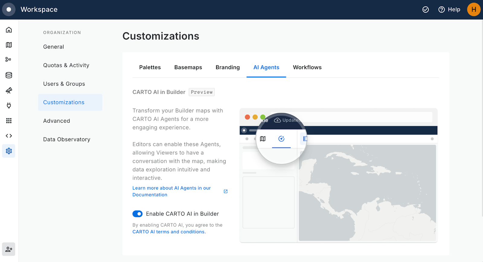
- First, your organization administrator needs to enable the AI Agent, which is disabled by default. They can do this under Settings Customizations > AI Agents tab > Enable (see below).
- Now any user can enable AI Agents in their maps! To do this, open any map in CARTO Builder.
- On the left of the screen, switch to the CARTO AI Agent panel (to the right of the basemaps panel) and enable the agent.
- From here, you can add context to help guide your AI Agent, suggest conversation starters for your end user and create a user guide.
- Share your map with your organization. Note: AI Agents are currently only available for members of your organization; maps shared externally (i.e. public-facing maps) do not have the AI Agent functionality.
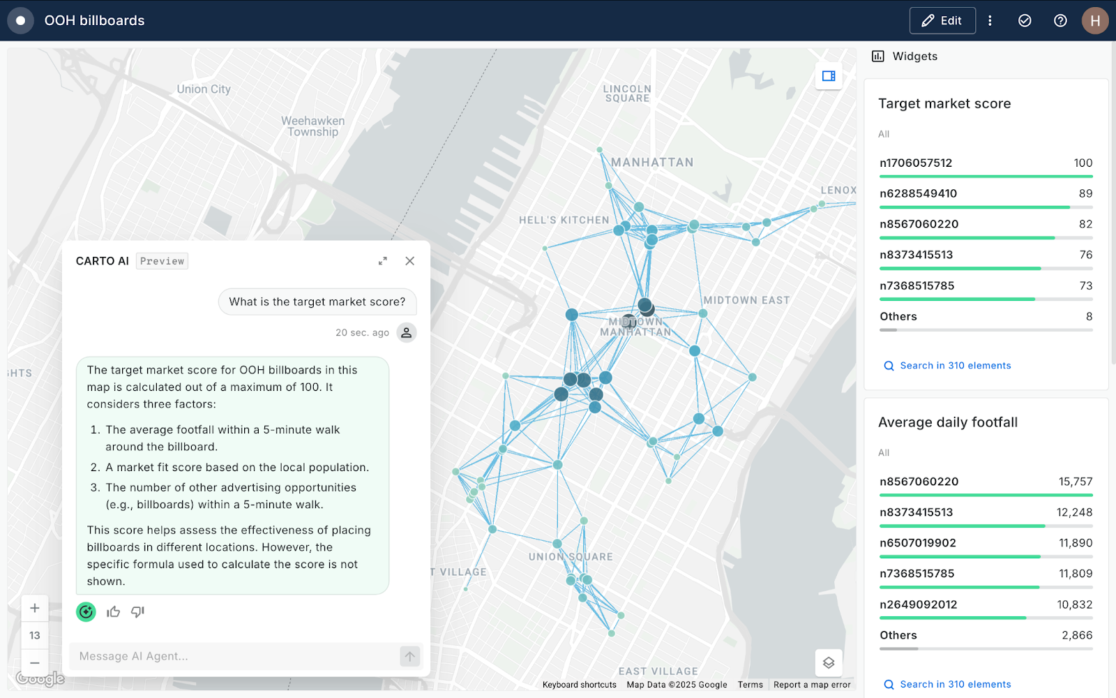
- Your end-users can now open the AI Agent (see below) and literally be able to “talk to the map” to draw insights from the data.
Head to the CARTO Academy for a full tutorial! Not a CARTO user yet? Sign up for a free 14-day trial here! You can also check out our Documentation for further details.
Real-Life Examples: CARTO AI Agents in Action
Empowering Clear Channel with smarter campaign planning
Clear Channel uses CARTO AI Agents to reduce inefficiencies and enable self-service access to critical geospatial data. This has significantly increased engagement and streamlined decision-making, helping them plan campaigns with greater precision.
Boosting Logistics Efficiency at Aramex
For logistics giant Aramex, CARTO AI Agents will identify optimal delivery routes in seconds, saving time and reducing operational costs.
Identifying network investment opportunities for telecoms
By analyzing network performance and demographic data, CARTO AI Agents help telecom companies prioritize investments where they matter most, boosting service quality and customer satisfaction. Watch this in action during our keynote at the State of Spatial Data Science Conference 2024 below - you can find all talks from this conference here.
What’s next for AI Agents?
At CARTO, we’ve got big plans for AI Agents! Here’s what you can look forward to in order to maximize productivity with AI:
- CARTO AI Agents will provide support to query map sources for richer insights, enabling dynamic generation of SQL queries based on user input
- Leverage CARTO Workflows to define analytical and data processing pipelines that your AI Agents can use to generate even richer insights.
- Integration of AI Agents with other AI API providers and models to further embed AI in your organizational processes.
Check out our What’s new page to learn about our latest updates, and follow us on LinkedIn to hear about them as they happen!
Boost Productivity and Accessibility with CARTO AI Agents
CARTO AI Agents makes spatial analysis more accessible than ever! By removing technical barriers to location insights, you can use AI to empower your team with faster and more transparent self-serve analytics.
Don’t miss out—request your free demo today and learn what CARTO AI Agents can do for you.