How to build a geospatial AI roadmap (that actually works)


Did you know that only 1 in 4 AI projects deliver their expected ROI? While AI adoption is accelerating across organizations, it’s often being applied in the wrong places.
GIS teams are typically using AI for individual productivity tasks: writing code snippets, summarizing reports, or generating quick map descriptions. These tools make analysts faster, but they rarely have a tangible impact at the organizational level.
Most organizations are still missing out on the huge potential that AI has for geospatial. Spatial data remains locked in silos - governed separately, accessible only to specialists, and disconnected from the AI systems driving business strategy. The result: even as AI becomes embedded in core enterprise workflows, Location Intelligence stays on the sidelines.
In this article, we’ll share how to close that gap with a framework for building a geospatial AI roadmap, which will help you:
- Move from individual productivity tools to enterprise-scale automation and collaboration.
- Connect spatial insights directly to decision-making systems.
- Govern geospatial data with the same rigor as enterprise data.
- Move your teams into the Agentic GIS era - where AI doesn’t just support analysis, but performs it safely and transparently.
Whether you’re leading a data strategy, GIS transformation, or AI innovation effort, the roadmap below will help you make that shift - from scattered experiments to governed, organization-wide impact.
Towards AI impact in 5 steps
Step 1: Assess your spatial governance maturity
Garbage in, garbage out. Everyone’s favorite data tagline has never been truer than now.
Without strong governance, even the smartest AI will deliver results that are at best inconsistent and biased, and at worst - just plain wrong. Geospatial reasoning can only be trusted when it's operating with data that is authoritative, documented and auditable.
Start by benchmarking your organization’s maturity using a Spatial Governance Maturity Model:
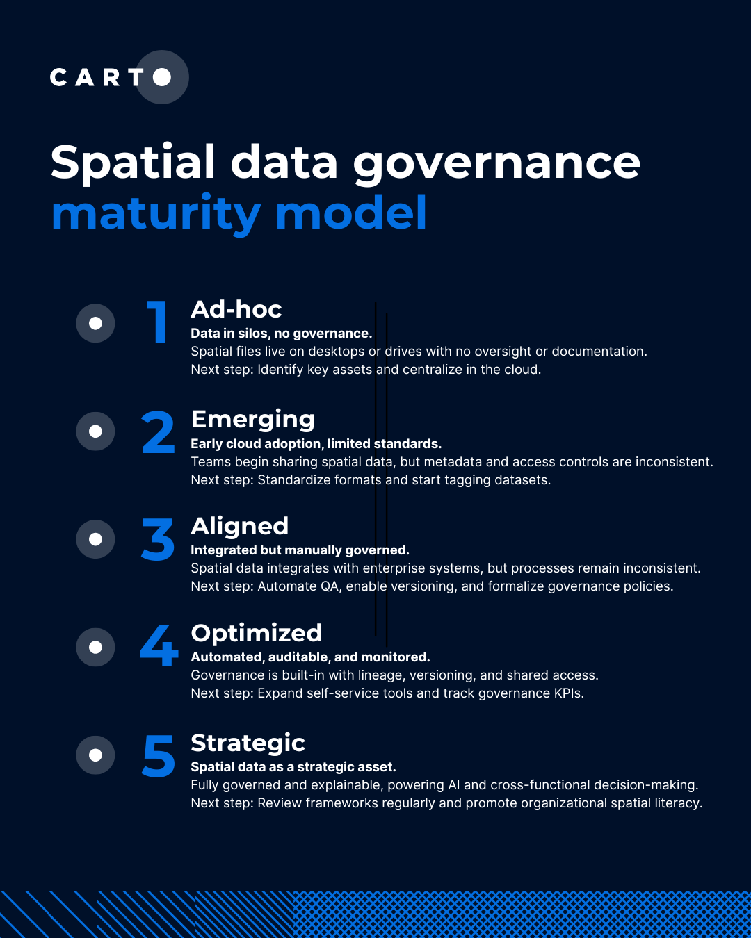
Learn more about how to apply the Spatial data governance maturity model in our report Spatial Data Governance in the Time of AI.
Remember that maturity isn’t uniform: your data science team might have fully automated QA systems in place, while field operations are still storing shapefiles locally. In practice, your governance is only as strong as its weakest link.
Now you’ve identified where your organization sits on the maturity model, use it as your baseline for improvement.
Step 2: Identify high-impact spatial workflows
The biggest mistake organizations make when implementing AI? They focus on what, not why. Instead of answering the question "what AI tools do we need?" you should start with "why are we aiming to implement AI?" For most organizations, it's about boosting productivity and saving costs.
This means you need to focus your AI investments where they’ll scale, not just speed up individuals. The real opportunity herelies in systematically identifying spatial workflows that can be automated and connected across the business.
Identify workflows that are:
- Frequent: repeated across multiple projects or teams, compounding efficiency gains.
- Impactful: influencing business-critical outcomes like investment, logistics, or expansion.
- Cross-functional: touching multiple departments, yet currently locked in silos.
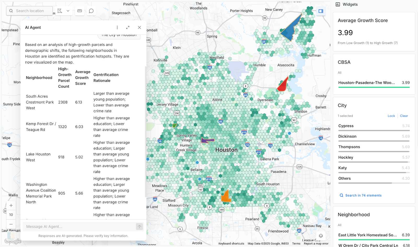
This is where Agentic GIS shows its value: turning repeatable workflows into AI Agents that can understand natural language, reason with geospatial data, and deliver instant insights for the whole organization.
With CARTO’s AI Agents, predictive growth insights move beyond data analysts and into the hands of every decision-maker. Now, anyone can ask our data questions like ‘Which neighborhoods will grow fastest?’ and get instant answers - speeding up site planning and providing a real competitive edgeAnand Singh , Vice President of Product at Cotality
Step 3: Make AI embedded across your tech stack
Many organizations approach AI as a bolt-on - another tool to manage rather than a capability embedded across their ecosystem. A successful AI implementation should do the opposite: it should live where your data lives and connect your tools.
To embed AI effectively:
- Prioritize integrations: With your high-impact, repeatable workflows identified, determine which systems need to communicate and how AI Agents will operate within them.
- Deploy governed services: Implement AI Agents natively inside your cloud data warehouse so spatial data never leaves your governed environment. This allows AI Agents to run securely with enterprise policies, audit trails, and lineage baked in. Your team can leverage vetted LLMs - such as OpenAI, Google Gemini and custom in-house endpoints - while maintaining full control over which models, tools, and datasets agents can access.
- Take AI to where your users are already working: Are your users already leveraging agentic platforms like Claude, Google’s Gemini Enterprise or even a custom enterprise platform? Leverage MCP servers to make your spatial tools available in these platforms to drive adoption.
You can see this in action below, where our Site Selection AI Agent is being deployed in Gemini Enterprise, with the user asking questions like "Which Maryland counties have high income, favorable demographics, and limited competition?" - receiving comprehensive site analysis together with interactive maps.
This approach ensures spatial reasoning isn’t siloed - AI become a core part of your tech stack, integrated with both enterprise data and user workflows, all while maintaining enterprise-grade governance and compliance.
Step 4: Enable everyone - from engineers to decision-makers
Did you know that 82% of workers don’t see how AI could be practically applied in their day-to-day work? Technology alone won’t deliver transformation. Even the most well designed AI will fail to create impact if your teams don’t know how to use it effectively.
Enablement should focus not just on how to use AI systems, but why you should:
- Technical enablement: Equip GIS and data teams to design, deploy, and monitor AI Agents. Analysts stay in the driver’s seat, building agents that automate complex workflows and amplify their expertise - whilst freeing up more of their time for high-value tasks.
- Decision enablement: Train analysts, planners, and executives to interact with AI systems using natural language to generate insights on demand. Business users become less reliant on direct support from GIS teams, streamlining their decision-making processes with truly self-service analytics.
- Cultural enablement: Encourage experimentation while maintaining ethical and governance standards, so AI is used responsibly and consistently.
By empowering everyone, spatial reasoning stops being a specialist capability and becomes a shared language for decision-making.
CARTO’s approach allows end users to ask natural-language questions about real-time population movement, traffic patterns, or demographics - and get instant, accurate answers. At the same time, our technical team can be confident that results are generated in the right, validated way. This removes bottlenecks, accelerates decision-making, and turns complex geospatial data into business value within seconds.Tim Rains , Lead Geospatial Data Scientist at BT Active Intelligence

With this balance of autonomy and assurance, spatial reasoning evolves from a specialist skill to a shared capability - transforming how your organization collaborates and decides.
Step 5: Learn, grow and scale
An AI roadmap isn’t a destination - it’s a cycle of learning and refinement. Once you’ve embedded spatial reasoning into daily workflows and enabled your teams, the focus shifts from adoption to acceleration.
Start small, measure fast, and scale what works. Track where AI Agents are saving time, reducing manual effort, or enabling faster, better decisions - then expand those successes across teams.
Start your Agentic journey today
Industry leaders like BT, Cotality and MiFibra are already embedding spatial reasoning into their AI strategies - turning data into faster insights, smarter planning, and measurable impact.
If your spatial roadmap doesn’t yet include AI reasoning, this is the moment to change that - request a demo with one of our experts to start planning what the future could look like.