Agentic GIS has landed: redefining geospatial for your organization


Did you know that global spending on AI is set to reach $644 billion in 2025? That’s more than the GDP of Sweden! IT departments are now projected to spend 1 in every $13 of their budgets on AI initiatives. However, most organizations still treat AI as a series of isolated productivity tools, rather than embedding it across the enterprise workflows that drive actual value.
In GIS, the gap between AI potential and value is even wider.
Spatial data, software, and expertise remain locked in silos, often confined to specialist teams. That means even as organizations advance their AI strategies, those gains rarely reach GIS, and the insights that could guide critical decisions don’t reach the people who need them.
At CARTO, we believe there’s a better way: Agentic GIS. This approach incorporates foundation models to power spatial reasoning and pattern detection at scale, embedded AI co-pilots (coming soon!) to streamline repetitive tasks, and - launching today - AI Agents! These agents can automate geospatial workflows, deliver instant insights, and put Location Intelligence in the hands of everyone across your organization.
What are AI Agents and how do they work?
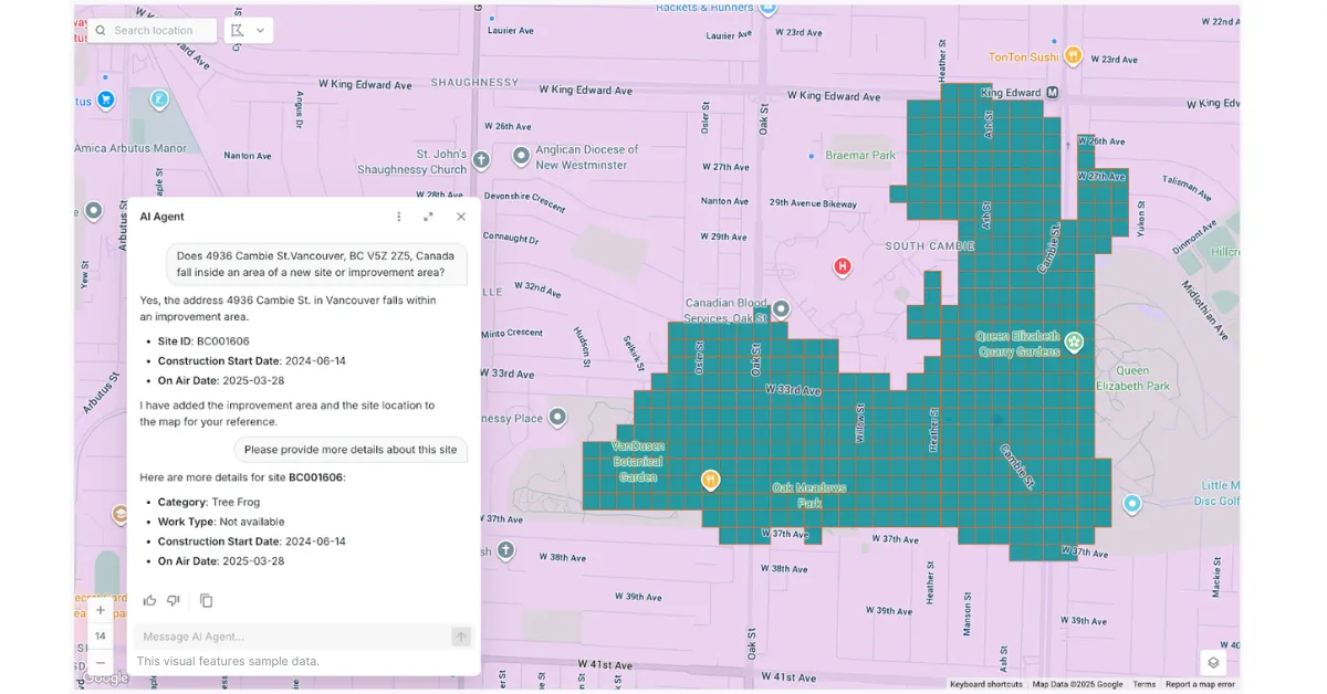
CARTO’s Agentic GIS platform transforms spatial analysis from a specialist-only resource into a company-wide decision-making engine. By building and deploying AI Agents, your team can automate complex workflows, generate instant insights, and unlock the full value of Location Intelligence - all while maintaining enterprise-grade governance and security.
Here’s how:
- Build AI Agents: Your GIS experts create AI Agents that understand natural language, reason with spatial data, and deliver insights to anyone in the organization - turning complex analysis into a simple, interactive experience. Your experts stay in the driving seat, determining the problems your agents can solve, the tools they can deploy and the data they can access.
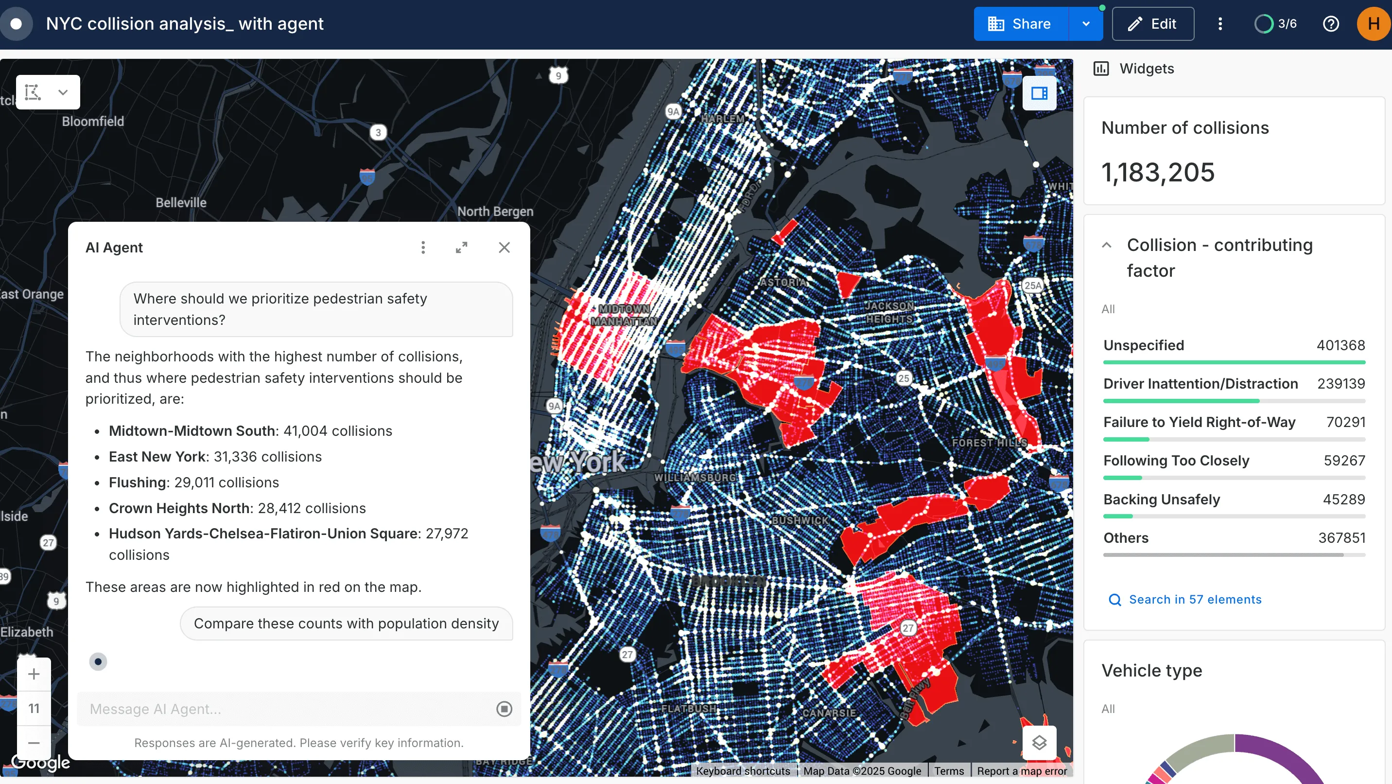
- Deploy data analysis tools: These AI Agents don’t just allow your users to interact with maps - they can be designed to run advanced queries and Workflows, so teams get answers without waiting for a data specialist.
- Experience enterprise-grade governance: CARTO's Agentic GIS approach allows you to operate entirely within your governed cloud environment. Your data never leaves your warehouse, and you can leverage your own vetted AI models and endpoints safely, ensuring full compliance and security.
- Benefit from frictionless interoperability: By deploying analysis pipelines as MCP tools in platforms like Agentspace and Claude, you can integrate spatial analysis across your existing AI ecosystem. This means you can allow external tools tap into your spatial workflows without ever compromising control or security.

Ready to try it yourself? Sign up for a free 14-day trial here!
Powering real decisions, now
The Agentic GIS era isn’t on the horizon - it’s already here. Organizations are using AI Agents to connect data, people, and decisions like never before, turning spatial analytics into a driver of real business and social value. Here are some of their stories:
TELUS: Transforming decision-making with AI Agents
TELUS is one of Canada’s leading telecommunications companies, known for its world-class networks and customer-first approach. TELUS is exploring the power of CARTO’s Agentic GIS to put insights directly in the hands of decision-makers. With AI Agents, teams will be able to interact with spatial data in a truly conversational way - whether that’s for checking cell coverage, reviewing upgrade plans, or launching targeted campaigns. All of this will be happening securely within TELUS’ controlled cloud environment, ensuring consistent, accurate, and protected information across the organization.
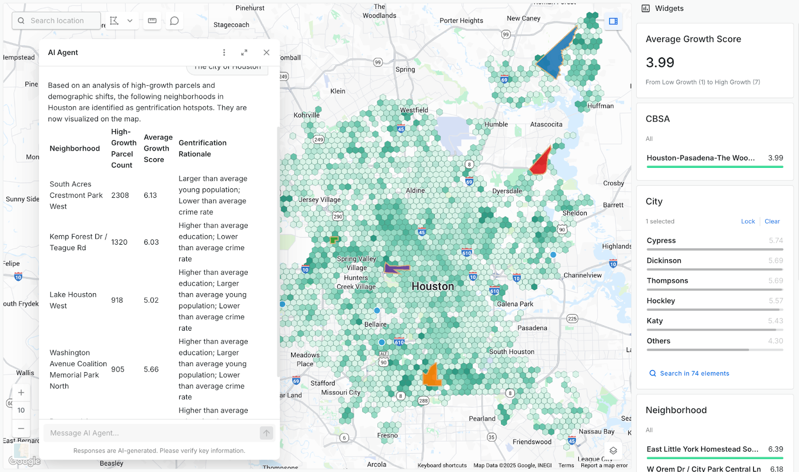
Cotality: Turning predictive growth data into a competitive edge
Cotality blends real-time data on land acquisitions, permits, and demographics to predict where U.S. growth will happen next. With CARTO’s Agentic GIS platform, those insights move beyond analysts to every decision-maker. AI Agents let teams ask questions like “Which neighborhoods in Dallas will see the most growth in the next 12 months?” and get instant answers - securely within their governed cloud. The result: faster, smarter site planning that turns predictive data into a competitive edge.
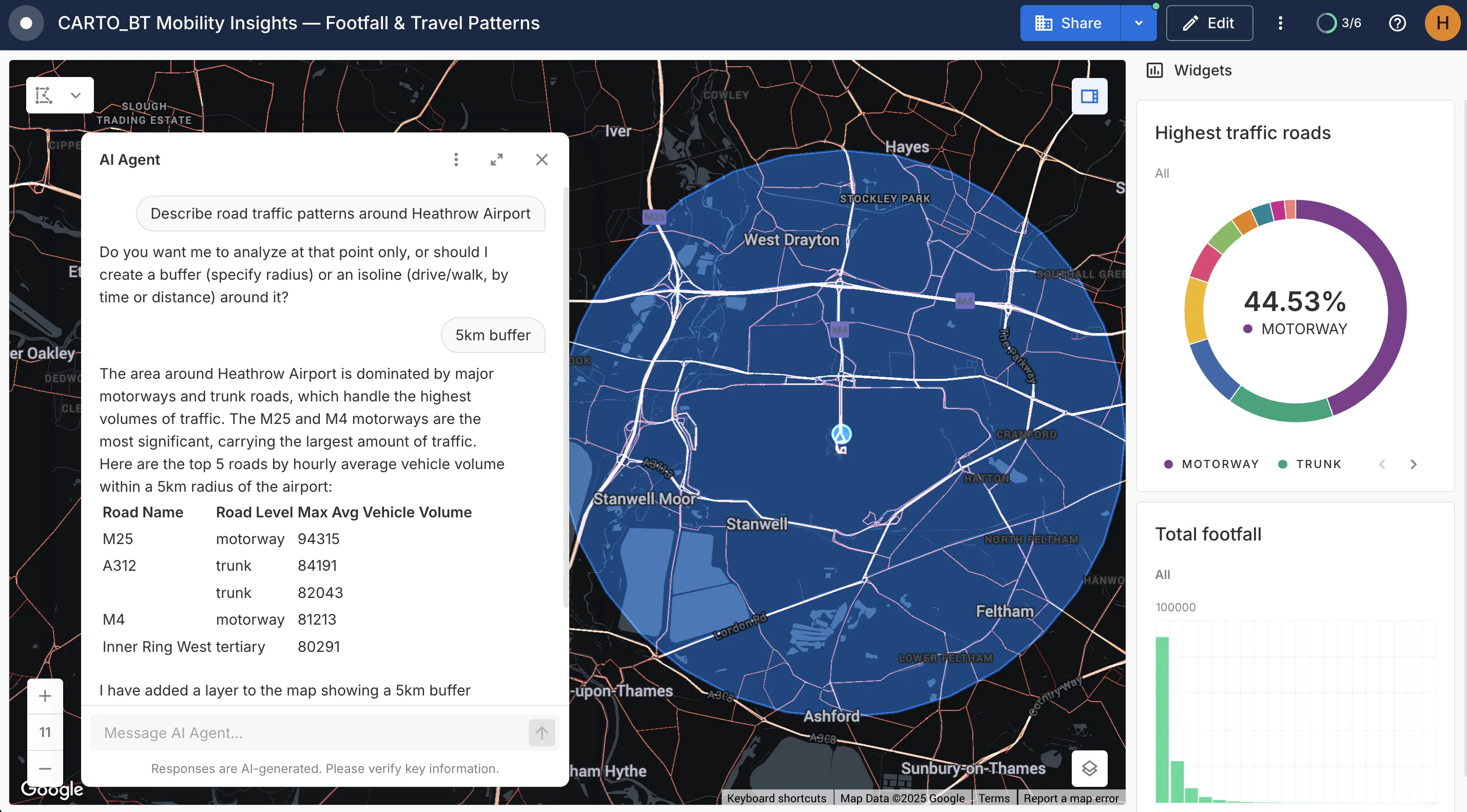
BT: Turning 25 billion daily mobility data points into insights
BT Group is a global leader in communications services, serving customers in over 180 countries. BT Active Intelligence processes over 25 billion daily mobility data points, but bottlenecks from ad-hoc analysis slowed down decision-making. By leveraging CARTO’s Agentic GIS platform, BT enabled every team to access real-time insights through AI Agents that translate complex mobility data into natural-language answers. Now, BT makes faster, smarter decisions - from predicting footfall to validating marketing campaigns - all while keeping data secure within Google Cloud.
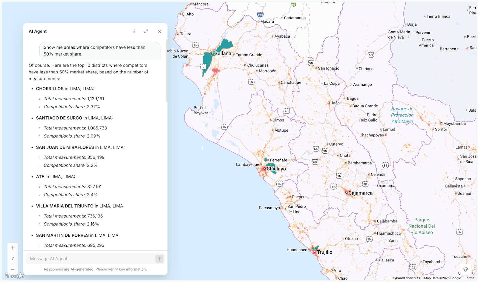
MiFibra: Winning in telecoms with faster, smarter decisions
MiFibra is a telecoms provider operating in a crowded market. Their organization needs more than speed to complete - they need smarter decisions across the organization. With CARTO’s Agentic GIS, spatial analysis is now a company-wide capability: AI Agents deliver instant insights for sales, operations, and expansion, enabling faster, more precise decisions while keeping data secure in their governed cloud.
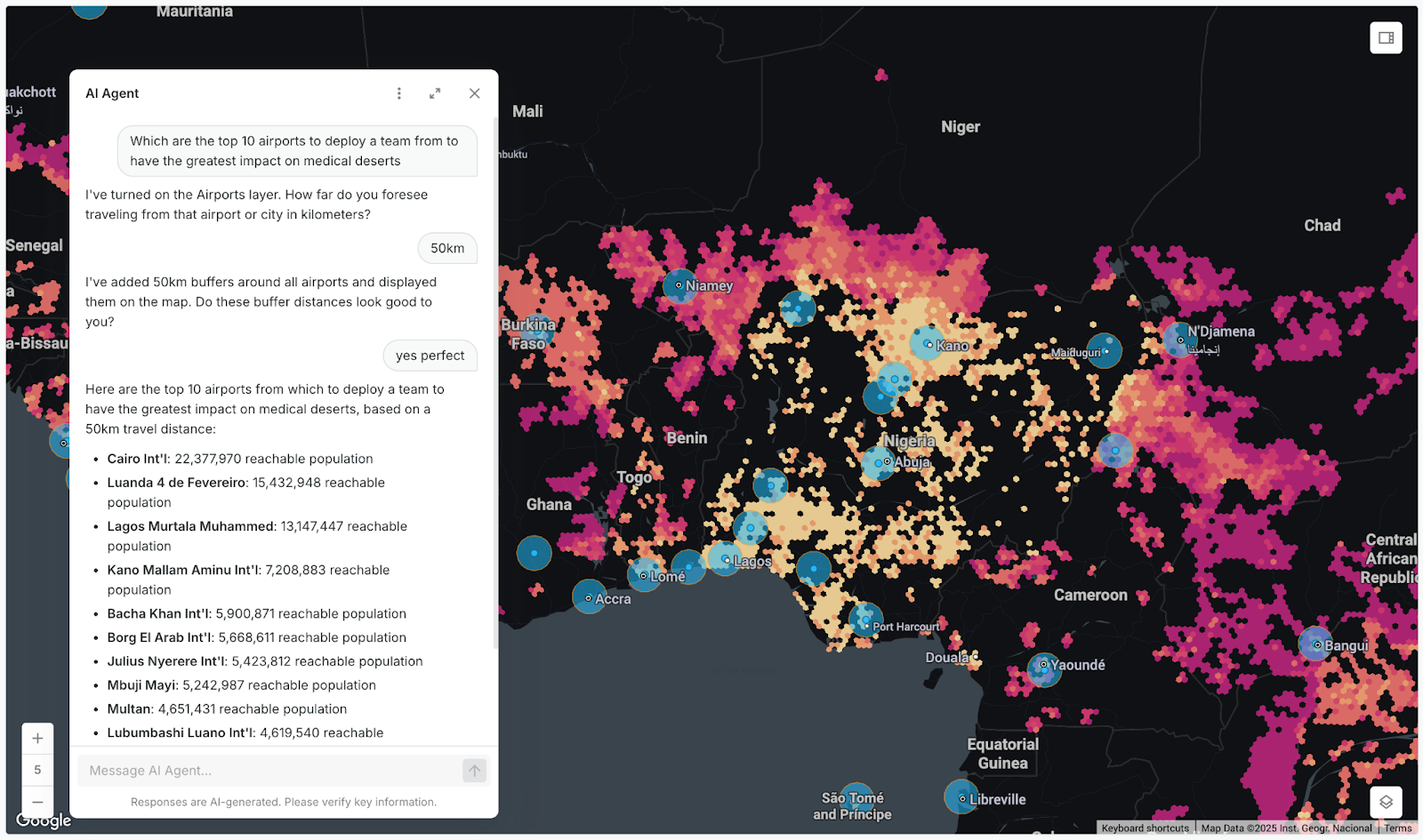
Virtue Foundation: Making healthcare data actionable for global impact
The Virtue Foundation advances healthcare, education, and women’s empowerment worldwide. Through its Actionable Data Initiative, it improves healthcare delivery in underserved regions with machine learning. By adopting CARTO’s Agentic GIS platform, doctors and researchers can now access healthcare and demographic insights through natural language - from planning missions to evaluating clinics - all while keeping data secure and centralized.
The future of GIS is agentic
Agentic GIS is more than a new feature - it’s a fundamental shift in how organizations harness spatial analytics. By allowing you to create AI Agents to automate complex workflows, break down silos, and make insights accessible, CARTO enables faster, smarter decisions - delivering real outcomes for your whole organization.
Luis Sanz, CEO at CARTO
Industry leaders are already putting this approach into action - and now is the time to make sure you don’t get left behind. Request a demo with one of our experts to learn how your organization can leverage AI Agents for more accessible and scalable decision-making.